Peak Forest Canal facts for kids
Quick facts for kids Peak Forest Canal |
|
|---|---|

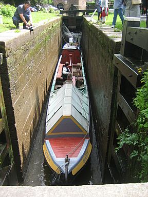
Horseboat Maria Descending Lock 9 on the Peak Forest Canal
|
|
| Specifications | |
| Length | 14.8 miles (23.8 km) |
| Maximum boat length | 72 ft 0 in (21.95 m) |
| Maximum boat beam | 7 ft 0 in (2.13 m) |
| Locks | 16 |
| Status | Navigable |
| Navigation authority | Canal & River Trust |
| History | |
| Original owner | Peak Forest Canal Company |
| Principal engineer | Benjamin Outram |
| Other engineer(s) | Thomas Brown |
| Date of act | 1794 |
| Construction began | 1794 |
| Date of first use | August 1796 |
| Date completed | 1805 |
| Date closed | Impassable by early 1960s |
| Date restored | 1974 |
| Geography | |
| Start point | Dukinfield Junction, Ashton-under-Lyne |
| End point | Bugsworth Basin, Buxworth |
| Branch(es) | Whaley Bridge Branch |
| Connects to | Ashton Canal Macclesfield Canal |
The Peak Forest Canal is a man-made waterway in northern England. It's a narrow canal, about 7-foot (2.13 m) wide. This canal is 14.8 miles (23.8 km) long. It connects to other canals, forming a big network across England and Wales.
Contents
Exploring the Peak Forest Canal's Path
How the Canal Works: Levels and Locks
The Peak Forest Canal has two main flat sections. These are like long, level pools of water. A set of 16 locks separates these two sections. These locks lift boats up by 209 feet (64 m) over about 1 mile (1.6 km).
People often call these sections the Upper and Lower Peak Forest Canal. Even though these names weren't used a long time ago, the "Lower Peak Forest Canal" name was made official in 1983. This part of the canal was then called a "Cruising Waterway."
The Canal's Journey: From North to South
The Lower Peak Forest Canal starts in Dukinfield in Greater Manchester. It connects with the Ashton Canal there. This part of the canal travels south through towns like Hyde and Woodley.
It then crosses the River Goyt on the impressive Marple Aqueduct. This aqueduct is a bridge that carries the canal over the river. After this, you reach the start of the Marple Locks. This lower section is about 6.9 miles (11.1 km) long. It passes through countryside with woods and fields, but also some industrial areas near Dukinfield.
The Marple Locks are a special 1 mile (1.6 km) section. Even though they are part of the Lower Peak Forest Canal, they are often seen as their own part. These 16 locks lift the canal 209 feet (64 m). They go through woods, a park, and the town of Marple. At the top, they connect with the Macclesfield Canal.
The Upper Peak Forest Canal is on the same level as the top part of the Macclesfield Canal. This means boats can travel a long way without needing to use any locks. This section of the canal is high up on the side of a valley. It offers amazing views of Furness Vale and the Peak District.
It passes through places like Disley and New Mills. The canal ends at Bugsworth Basin in Derbyshire. This section is also about 6.9 miles (11.1 km) long. Bugsworth Basin was once a very busy place. It has recently been reopened and is now a popular spot for boats. There's also a short branch of the canal that goes to Whaley Bridge. This was once connected to a railway that crossed the Peak District.
Popular Boat Routes: Cruising Rings
The part of the canal from Dukinfield Junction to Marple Junction is part of a famous boating route. This route is called the Cheshire Ring.
The Peak Forest Canal's Story
Why the Canal Was Built
A special law was passed in 1794 to allow the canal to be built. Its main goal was to transport huge amounts of limestone. This limestone was found in places like Dove Holes, which is over 1,000 feet (300 m) above sea level.
Because Dove Holes was so high up, the canal couldn't reach it directly. So, the canal ended at Bugsworth Basin. From there, a special railway, called the Peak Forest Tramway, carried the limestone. This railway was 6 miles (9.7 km) long and used gravity to move the stone down from the quarries.
Building the Canal: A Big Project
Important people like Samuel Oldknow and Richard Arkwright Junior helped fund the canal. Thomas Brown surveyed the route. The main engineers were Benjamin Outram and Thomas Brown.
Work started on the lower part of the canal first. This was near Ashton and Hyde Hall, where new coal mines were opening. The goal was to start earning money as soon as possible. There were some challenges during construction. For example, ideas for using cast iron instead of stone for the Marple Aqueduct were considered but later dropped.
Engineers also faced pressure to build the section from Bugsworth to Marple quickly. This was important for Samuel Oldknow's coal mines and lime kilns. By 1796, the tramway and the canal up to Marple were open.
However, there wasn't enough money to finish the locks and the aqueduct at Marple. A temporary railway was built to connect the canal sections. The arches of the Marple Aqueduct were finished in 1798. The whole canal finally opened along its full length in 1800.
How the Canal Was Used
The upper part of the canal and the tramway opened for business on August 31, 1796. Bugsworth Basin quickly became a very busy place. It was where limestone moved from the tramway onto boats.
A manager named Gernan Wheatcroft helped a lot with running the canal. He was very good at his job. The canal company even hired an expert to write about how useful lime was for farming. This helped them sell more limestone.
Trade grew quickly, and more railways were needed. Finding enough workers was also a challenge. The company rented cottages for workers to live in. They even offered "a good flannel waistcoat and trousers" and a jug of ale each day to attract workers.
The railway at Marple was still a problem. The canal company still needed money to finish the Marple locks and a reservoir. Finally, they borrowed £24,000, and the work was completed in 1805.
At Bugsworth, limestone from the tramway was either loaded onto boats or burned in lime kilns. Burning limestone made "quick lime," which was also sold. Transporting limestone, quick lime, and coal for the kilns brought in most of the canal company's money.
The Canal's Decline and Rebirth
When railways became more common, the canal started to lose its business. In the 1920s, the Peak Forest Tramway and Bugsworth Basin closed. Later, the lower part of the canal and Marple locks were not used much. By the early 1960s, you couldn't even travel on the lower canal anymore.
However, in the late 1960s and early 1970s, groups like the Peak Forest Canal Society worked hard to restore the canal. They reopened the Peak Forest and Ashton Canals on April 1, 1974. The Lower Peak Forest Canal was officially made a "Cruising Waterway" in 1983.
Bugsworth Basin stayed unused for much longer. But a group called the Inland Waterways Protection Society worked to restore it. After a lot of professional work, it finally reopened for boats in 2003.
 | Jessica Watkins |
 | Robert Henry Lawrence Jr. |
 | Mae Jemison |
 | Sian Proctor |
 | Guion Bluford |


