Aire and Calder Navigation facts for kids
Quick facts for kids Aire and Calder Navigation |
|
|---|---|

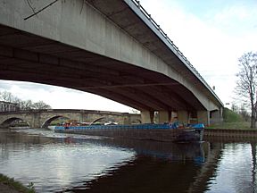
One of the 600 tonne barges used on the Navigation
|
|
| Specifications | |
| Length | 34 miles (55 km) |
| Maximum boat length | 200 ft 0 in (60.96 m) (originally 58 ft 0 in or 17.68 m) |
| Maximum boat beam | 20 ft 0 in (6.10 m) (originally 14 ft 6 in or 4.42 m) |
| Locks | 16 |
| Status | Open |
| Navigation authority | Canal and River Trust |
| History | |
| Original owner | Aire and Calder Navigation Company |
| Principal engineer | John Hadley |
| Date of act | 1699 |
| Date of first use | 1704 |
| Geography | |
| Start point | Leeds (Aire) and Wakefield (Calder) |
| End point | Goole Docks |
The Aire and Calder Navigation is a famous waterway in West Yorkshire, England. It's made from parts of the Rivers Aire and Calder that were changed to make them easier for boats to use. This process is called canalisation.
The first big improvements to these rivers were finished in 1704. This made the River Aire navigable (meaning boats could travel on it) all the way to Leeds. The River Calder became navigable to Wakefield. To do this, 16 locks were built. Over time, the locks and the water depth were made bigger so that even larger boats could use the system.
In 1778, the Selby Canal was opened. This created a new path for boats, bypassing a section of the Aire. Later, in 1826, a new canal from Knottingley to the town of Goole was built. This gave boats a much shorter way to reach the River Ouse. In 1905, the New Junction Canal was added. It connected the Aire and Calder system to the River Don Navigation.
Steam tugs, which are powerful boats that pull others, started being used in 1831. In the 1860s, a clever system of special compartment boats was introduced. These were later nicknamed "Tom Puddings." They carried coal, which was then lifted and unloaded into ships using huge machines called hydraulic hoists. This system was so good that the canal carried over 1.5 million tons of coal each year at its busiest! It was used until 1986. To handle these long trains of compartments, many locks were made much longer.
Today, the upper parts of the navigation are mostly used for fun activities like leisure boating. However, there is still important commercial traffic on the waterway. In 2007, about 300,000 tons of goods were carried. Most of this traffic is now petroleum and gravel, not coal. Coal was what made the navigation so successful for 150 years.
Contents
The Aire and Calder Navigation starts with the River Calder from Wakefield to Castleford. Here, it meets the branch coming from Leeds, which follows the River Aire. The River Aire then flows east to Bank Dole Junction. After that, it goes northeast to Haddlesey. From Haddlesey, it used to wind its way to join the River Ouse at Airmyn.
However, the section below Haddlesey is no longer part of the main navigation. A broken lock stops boats from using it. Instead, the Selby Canal now flows north from Haddlesey to the Ouse at Selby.
Below Dole Bank Junction, the Knottingley and Goole Canal flows east. It joins the Ouse at Goole. Near Newbridge, this part of the navigation runs next to the Dutch River. This artificial channel was built in 1635 to help with flooding.
The Aire and Calder Navigation still connects Leeds and Wakefield to York and the Humber. From the Humber, boats can reach the River Trent. Newer canals also make this navigation a key link in England's waterway network.
- Beyond Leeds, the Leeds and Liverpool Canal takes boats over the Pennine mountains.
- The Calder and Hebble Navigation connects at Wakefield. It allows boats to reach the Huddersfield Broad Canal and Huddersfield Narrow Canal, and the Rochdale Canal.
- The Selby Canal connects to the Ouse. From there, boats can go upstream to York and Ripon. They can also go downstream to the River Derwent.
- Beyond Goole, boats can reach the Humber, then Hull, Immingham, and the North Sea.
- The Sheffield and South Yorkshire Navigation connects via the New Junction Canal. This links to Doncaster, Rotherham, Sheffield, and the tidal River Trent at Keadby.
In the early 1600s, the River Aire was navigable up to Knottingley. Boats carrying up to 30 tons used it. Traders in Leeds really wanted a way to get their woollen cloth to market more easily. They tried to get laws passed in 1621 and 1625, but it didn't work.
By the end of the 1600s, people were more open to improving rivers for boats. A new plan was made in 1698. Wool traders from Leeds and merchants from Wakefield supported it. John Hadley surveyed the Aire, and Samuel Shelton surveyed the Calder. Even though many people supported the plan, the City of York was against it. They worried it would harm the River Ouse.
The plan was debated a lot in Parliament. Finally, in May 1699, the law was passed. It named 18 people to manage the improvements. Nine were from Leeds, and nine were from Wakefield. They would oversee changes to the River Aire (from the Ouse at Airmyn to Leeds) and the River Calder (from Castleford to Wakefield). They could build new cuts (short canals) with locks to bypass weirs (small dams). They could also create towpaths for horses to pull boats.
John Hadley became the engineer right away. By 1704, the first work was done. This included 12 locks on the Aire and 4 on the Calder. These locks were about 58 to 60 feet long and 14.5 to 15 feet wide. They had about 3.5 feet of water depth over their sills (the bottom of the lock gate).
The money for the project came from committees in Wakefield and Leeds. The navigation started paying regular profits to its owners from 1718. It was also rented out to groups who collected tolls and did repairs. By the 1720s, a lot of coal was being carried, along with wool and corn.
Connecting to Goole
In 1817, there were ideas for new canals. One idea was to connect Knottingley to the Dutch River. Another was to connect the Barnsley Canal to the Dutch River. The Aire and Calder company was doing very well, earning a lot of money from tolls. So, they decided to propose their own new route to the Dutch River.
The plan changed to connect to Goole instead. John Rennie was asked to survey the route. People who were against the plan were reassured that the old route to Airmyn and the Selby Canal would still be kept open. Rennie suggested building docks at Goole, not just a lock. He also said there should be 7 feet of water available.
Rennie passed away in late 1821, and George Leather took over as engineer. Building work at Goole started in September 1822. The company even built much of the new town of Goole, as well as the docks.
The new canal and docks opened on July 20, 1826. There was a barge lock (72.5 by 22 feet) and a ship lock (120 by 33.7 feet). The ship lock could handle vessels up to 400 tons. The new section of canal was about 18.7 miles long. It had locks at Ferrybridge, Whitley, Pollington, and Goole. Goole became an official port in 1827. The whole project cost a lot of money, but it was a big success.
The company then looked at making the water 7 feet deep all the way to Leeds and Wakefield. Thomas Telford surveyed these routes. A new law was passed in June 1828 to allow these improvements. Work started on a new cut at Castleford and on the line to Leeds. The Leeds line was finished in April 1835. The banks were made stronger to handle steam tugs, which were planned to be used. The seven locks above Castleford were all 18 feet wide.
Improvements to the Calder to Wakefield took longer. There were problems with floods and building foundations for an aqueduct (a bridge that carries water) over the River Calder at Stanley Ferry. The improvements cost around £510,000.
Making it Modern
When railways arrived in the 1840s, the Aire and Calder tried to work with them. But they still saw a big drop in trade. Thomas Hammond Bartholomew, the chief engineer, had been trying out steam power since 1813. Steam paddle tugs had been used since 1831. By the time he died in 1852, most of the traffic was pulled by steam tugs.
His son, William Hammond Bartholomew, took over. He soon introduced tugs with propellers. These could pull ten keels (boats), carrying 700 tons. But they were slow at locks because the keels had to go through one at a time. So, between 1860 and 1867, the locks from Goole to Castleford were made longer (206 by 22 feet).
In 1861, Bartholomew suggested a new system of boats made of separate parts. Each "train" would have six compartments, plus a front and back section. These compartments, or "tubs," would be unloaded into ships using a hydraulic hoist at Goole. The hoist would lift them from the water and tip them over.
By late 1864, the first of these special boats were working. The back section was replaced by a pusher tug. Soon, more compartments were ordered. It was found that a tug and seven compartments could fit into the larger locks. In 1874, people started calling them "Tom Puddings" because of their wobbly movement.
The trains grew to ten or eleven tubs. But these long trains were hard to steer from the back. So, the tugs moved to the front and pulled the assembly. In 1880, they carried over 150,000 tons. By 1913, there were 18 tugs and over 1,000 compartments. They carried over 1.5 million tons of coal!
After the First World War, the locks were improved again. They were made even longer (457 feet). This allowed trains of 19 compartments to operate regularly. Sometimes, trains as long as 38 tubs were tried, but 19 was the usual maximum. The compartments continued to carry about half a million tons of coal until the late 1960s. This was long after most other British canals stopped carrying commercial traffic. But as the coal industry declined, the compartment traffic stopped in 1986.
The 20th century saw two more big improvements. In 1905, the New Junction Canal connected the Aire and Calder to the Sheffield and South Yorkshire Navigation. In the 1960s, the navigation was updated again. Locks from Goole to Leeds were made bigger to fit "Euro-barges" that could carry 600 tons. The smallest lock is at Knostrop, which is 203 by 22 feet. Euro barges are 200 by 20 feet.
A big challenge was the cast iron aqueduct at Stanley Ferry. It carried the navigation over the River Calder. Engineers found that parts of it were overloaded. So, in 1981, a new concrete aqueduct was built nearby. The whole new structure was pushed into place by powerful jacks. The old aqueduct was left there and can still be seen.
Coal mining, which made the navigation so successful, also caused problems. In 1988, the canal bank near Lemonroyd lock collapsed into a mine. This caused the mine to flood, creating a large lake. A new law was needed to build about 1.9 miles of new waterway. The old locks at Kippax and Lemonroyd were replaced by one new lock at Lemonroyd. The mine is now a nature reserve.
What Travels on the Canal?
A special version of the compartment boat system was used to deliver coal to the Ferrybridge "C" power station. Starting in 1967, trains of three coal pans were used. These were pushed by a tug when loaded. The pans were filled with coal at the mine and pushed to the power station. There, a hoist lifted each pan from the canal and tipped it over to drop the coal onto a conveyor belt.
Nine tugs and 35 pans were used. Each pan held about 170 tons. By the time the last load left Astley mine in 2002, 43 million tons had been delivered to Ferrybridge this way. Coal carrying stopped in 2003 because the St Aidan's mine ran out of coal. Also, coal from Kellingley mine had too much sulphur.
In 1974, British Waterways tried a system called BACAT (Barges Aboard Catamaran). This involved trains of barges pushed by a tug. These barges would be loaded onto a special ship with two hulls. The ship would then carry them across the North Sea to other waterways without having to unload and reload the cargo. This idea failed after 18 months. Dock workers at Hull protested because they thought the system would take away their jobs.
Today, most of the commercial traffic on the navigation is petroleum tankers and gravel barges.
Boating for Fun
The Aire and Calder was built for carrying goods. Even though less freight is carried now, especially since coal deliveries stopped, the navigation still moved 300,000 tons of freight in 2007.
The section from Leeds to Castleford and much of the Wakefield branch are now mostly used for fun. People enjoy leisure boating there. However, below Castleford, the waterway looks more industrial. Pleasure boats must give way to commercial vessels. The large 600-ton vessels create big waves and are not as easy to steer as smaller boats.
The western part of the navigation, which used to be industrial, now looks like a tree-lined, winding river. The eastern part, sometimes called the Knottingley and Goole Canal, is different. It has long, straight sections that go through flat farmland.
Between Wakefield and Leeds, via Castleford, the navigation is part of a circular cruising route called a "ring." This ring is formed by the Leeds & Liverpool Canal and the Huddersfield Broad Canal or Rochdale Canal. The Outer Pennine Ring uses the Huddersfield Canal. The North Pennine Ring uses the Rochdale Canal.
Beyond Castleford, boaters can travel to Selby, York, Goole, Sheffield, and Keadby. If the Barnsley Canal and the Dearne and Dove Canal are restored, the section between Wakefield and the New Junction Canal might become part of a new "Yorkshire Ring."
Points of Interest
| Point | Coordinates (Links to map resources) |
OS Grid Ref | Notes |
|---|---|---|---|
| Crown Point Bridge | 53°47′38″N 1°32′06″W / 53.7938°N 1.5349°W | SE307331 | Where it meets the Leeds and Liverpool Canal |
| Woodlesford Lock | 53°45′37″N 1°26′41″W / 53.7603°N 1.4448°W | SE367294 | On the Leeds Branch |
| Fall Ings Lock | 53°40′25″N 1°28′56″W / 53.6737°N 1.4823°W | SE343198 | Where it meets the Calder and Hebble Navigation |
| Site of Barnsley Canal Junction | 53°40′31″N 1°28′21″W / 53.6752°N 1.4725°W | SE349199 | |
| Stanley Ferry Aqueducts | 53°42′09″N 1°27′45″W / 53.7025°N 1.4624°W | SE355230 | Bridge over River Calder |
| Woodknock Lock | 53°43′17″N 1°24′27″W / 53.7213°N 1.4075°W | SE391251 | Plus old Fairies Hill Locks |
| Castleford Junction | 53°43′54″N 1°21′31″W / 53.7316°N 1.3585°W | SE424263 | Where Leeds and Wakefield Branches join |
| Bank Dole Junction | 53°42′34″N 1°13′52″W / 53.7094°N 1.2311°W | SE508239 | River Aire and Knottingley-Goole section |
| Haddlesey Flood Lock | 53°43′52″N 1°08′12″W / 53.7310°N 1.1368°W | SE570264 | Where River Aire and Selby section meet |
| Selby Lock | 53°46′56″N 1°03′27″W / 53.7823°N 1.0574°W | SE622321 | Where it meets the River Ouse Navigation |
| Whitley Lock | 53°41′32″N 1°08′37″W / 53.6922°N 1.1435°W | SE566220 | On the Knottingley-Goole section |
| Southfield Junction | 53°39′39″N 1°00′57″W / 53.6609°N 1.0159°W | SE651187 | Where it meets the New Junction Canal |
| Ocean Lock, Goole | 53°41′56″N 0°52′02″W / 53.6988°N 0.8671°W | SE748230 | Where it meets the River Ouse |
 | Claudette Colvin |
 | Myrlie Evers-Williams |
 | Alberta Odell Jones |


