Selby Canal facts for kids
Quick facts for kids Selby Canal |
|
|---|---|

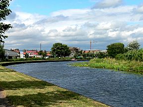
The canal approaching the River Ouse
|
|
| Specifications | |
| Length | 6 miles (9.7 km) |
| Maximum boat length | 78 ft 6 in (23.93 m) |
| Maximum boat beam | 16 ft 6 in (5.03 m) |
| Locks | 2 |
| Status | navigable |
| Navigation authority | Canal and River Trust |
| History | |
| Original owner | Aire and Calder Navigation |
| Principal engineer | William Jessop |
| Other engineer(s) | John Gott |
| Date of act | 14 June 1774 |
| Date completed | 29 April 1778 |
| Geography | |
| Start point | West Haddesley |
| End point | Selby |
| Connects to | Aire and Calder Navigation, River Ouse |
The Selby Canal is a 6-mile (9.7 km) long waterway in Yorkshire, England. It has two locks and connects the village of West Haddlesey to the town of Selby. Here, it joins the River Ouse.
The canal opened in 1778. For many years, it was the main route for boats from the Aire and Calder Navigation. This changed in 1826 when a new, shorter canal opened from Ferrybridge to Goole. After this, Selby became less busy. However, boats heading to York still used the Selby Canal.
In 1828, plans were made to make the canal deeper. The people of Selby even took legal action to make sure the company followed the rules. The locks were made bigger in 1885. Later, in 1962, the canal came under the care of British Waterways. When the River Ouse also came under their control, the Selby Canal was promoted as a route to York. More and more boats started using it.
Today, the Selby Canal is usually thought to include a section of the River Aire. This makes the modern canal about 11.7 miles (18.8 km) long with four locks.
Contents
Building the Selby Canal
In the late 1760s, people were not happy with the Aire and Calder Navigation. There were ideas to build new routes or improve existing ones. One plan was for a canal from Leeds to Selby, surveyed by John Longbotham. This canal would have been over 23 miles (37 km) long. It would have had ten locks and a tunnel.
The estimated cost was £59,468, which was a lot of money back then. People quickly raised the money. A bill was presented to Parliament in December 1772. The Aire and Calder Navigation also proposed improvements to the River Aire. However, Parliament did not make a decision on either plan.
Choosing a Route
After this, the Aire and Calder company decided a canal to Selby might be better. William Jessop surveyed a route from Haddlesey to Selby. This plan included a lock at Selby to connect with the River Ouse. It also needed floodgates at Haddlesey.
By 1774, the Leeds and Selby Canal plan was supported by another company. Both sides presented their ideas to Parliament. The Leeds and Selby plan was rejected. But the Aire and Calder bill became a law on 14 June 1774.
Canal Construction
The company hired Jessop as an engineer, with John Gott helping as the resident engineer. Construction started in early 1775. The canal cost £20,000 to build. It opened with a big celebration in Selby on 29 April 1778.
The town of Selby grew quickly after the canal opened. It even had a customs house. This meant ships could go straight to the North Sea without stopping at Hull. The canal was successful, but it had some problems. A 2-mile (3.2 km) section had sandy banks. This sand often blocked the canal, so it needed regular dredging. Also, the canal was only 3.5 feet (1.1 m) deep, which was too shallow for larger boats.
Changes and Challenges
A new law was passed on 30 June 1820. This allowed for a new canal route and other improvements. Plans grew to include a basin and locks at Goole in 1821. The canal depth was also increased from 6 feet (1.8 m) to 7 feet (2.1 m).
The main engineer, John Rennie, died in 1821. George Leather took over and planned a ship dock at Goole. In 1824, the start of the new canal was moved to Ferrybridge. The new canal opened on 20 July 1826. It was delayed partly because of a drought. Boats could still reach the Selby Canal by using Dole Bank Lock.
Selby's Decline
The Aire and Calder company started using Goole instead of Selby for their boats. Slowly, boat owners moved to the new location. This caused a steady decline in trade at Selby.
More improvements were made to other canal routes. These changes would allow 100-ton boats to reach Leeds and Wakefield. A new law on 19 June 1828 included these plans. It also said the Selby Canal should be deepened to 5 feet (1.5 m). The company tried to do this by raising water levels. But this was not legal.
The people of Selby were not happy. They took further legal action. This made the company do more work in 1832 and 1833. They even had to build a new lock into the Ouse. Traders from other towns asked for the canal to be even deeper, but this was refused.
Later Years
Most boats on the Aire and Calder now used Goole. But trade with York still used the Selby Canal. The town of Selby continued to decline. There was a short boost in 1834 when the Leeds and Selby Railway opened. But this ended in 1840 when a railway from Selby to Hull opened.
The locks on the main Aire and Calder canals were made longer by 1873. This allowed for larger boats. The locks on the Selby line were rebuilt between 1885 and 1886. This included Dole Bank Lock, Beal Lock, Haddlesey Flood Lock, and Selby Lock. The locks were made 78.5 feet (23.9 m) long and 16.5 feet (5.0 m) wide. The canal depth was increased to 6 feet (1.8 m).
In January 1948, the canal became government-owned. It was taken over by the British Transport Commission. Later, the British Waterways Board took control in 1962.
The Canal Today
Before 1985, the River Ouse was managed by a different group. But later, it was transferred to British Waterways. The Selby Canal was then promoted as a route to York. By 2006, over 2,000 boats used Selby Lock each year. This was more than double the number from 1988. Today, the canal is mostly used by leisure boats. Part of the path next to the canal is now part of the Selby Horseshoe Walk.
Boats using the canal can be up to 78.5 feet (23.9 m) long. They can be 16.5 feet (5.0 m) wide. The maximum depth a boat can go is 4 feet (1.2 m). The maximum height for a boat is 9.7 feet (3.0 m).
As mentioned, the modern Selby Canal includes a section of the River Aire. This part runs from Bank Dole Junction to West Haddlesey. This makes the canal 11.7 miles (18.8 km) long with four locks. The River Ouse at Selby has tides. So, the lock can only be used at certain times. A lockkeeper is there to help when boats can pass. The lock is fully automatic.
Canal Route Features
From the main Aire and Calder Canal, a short branch leads to the River Aire. A lock here lowers the water level by 7 feet (2.1 m). The river then winds to Beal. Here, a bridge crosses it, and a large weir drops the water level by another 8 feet (2.4 m). Beal Lock is next to the weir.
After about 3.7 miles (6.0 km), the River Aire continues straight. Boats turn sharply left into Haddlesey Flood Lock. This is the start of the Selby Canal. The river section has high flood banks. Haddlesey Lock is usually open. It only closes if there is a lot of water in the Aire.
Bridges and Structures
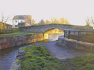
Soon after Haddlesey Lock, you'll see Tankard's Stone Bridge. It was built when the canal was made and is a Grade II listed structure. It's a humpbacked bridge made of sandstone.
Just before Paper House Bridge, a drain enters the canal. Paper House Bridge is also a Grade II listed humpback bridge. It was built in the late 1700s. There are two round ponds near this bridge.
Next, the East Coast Main Line railway crosses the canal. Then comes Burton Hall Bridge. This bridge was designed by William Jessop. It was built when the canal was first made. It has an iron roller to protect it from boat towing ropes.
The A19 road crosses at Burn Bridge. Another drain passes under the canal. Then you'll see where an old railway bridge used to be. After that, Brayton Lane Bridge crosses the canal. The Doncaster to Selby railway line crosses at Brayton Railway Bridge. The A1041 road crosses at Bawtry Road Bridge.
The only swing bridge on the canal is just before the final lock. Boaters operate this bridge themselves. A wider section of the canal marks where old wharves and a dry dock used to be. The lock itself and the nearby lock house are also Grade II listed structures.
Points of interest
| Point | Coordinates (Links to map resources) |
OS Grid Ref | Notes |
|---|---|---|---|
| Selby Lock | 53°46′58″N 1°03′27″W / 53.7828°N 1.0574°W | SE622322 | Junction with River Ouse |
| Brayton Railway Bridge | 53°46′14″N 1°04′18″W / 53.7705°N 1.0717°W | SE612308 | Doncaster to Selby Line |
| East Coast Main Line bridge | 53°45′09″N 1°07′28″W / 53.7524°N 1.1245°W | SE578288 | |
| West Haddlesey Flood Lock | 53°43′53″N 1°08′10″W / 53.7315°N 1.1360°W | SE571264 | |
| Beal Lock | 53°43′25″N 1°11′26″W / 53.7236°N 1.1905°W | SE535255 | |
| Bank Dole Lock | 53°42′35″N 1°13′37″W / 53.7097°N 1.2270°W | SE511239 |
 | Selma Burke |
 | Pauline Powell Burns |
 | Frederick J. Brown |
 | Robert Blackburn |


