New Junction Canal facts for kids
Quick facts for kids New Junction Canal |
|
|---|---|

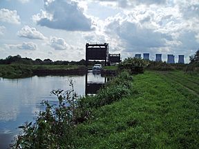
Guillotine gates protect the canal from the River Don
|
|
| Specifications | |
| Maximum boat length | 215 ft 0 in (65.53 m) |
| Maximum boat beam | 22 ft 6 in (6.86 m) |
| Locks | 1 |
| Status | Operational |
| Navigation authority | Canal and River Trust |
| History | |
| Original owner | Aire and Calder Navigation, Sheffield and South Yorkshire Navigation Co |
| Date of act | 1891 |
| Date of first use | 1905 |
| Geography | |
| Start point | River Don |
| End point | Aire and Calder |
| Connects to | Aire and Calder Navigation, River Don Navigation |
The New Junction Canal is a special waterway in South Yorkshire, England. It's part of a bigger system called the Sheffield and South Yorkshire Navigation. This canal was built with money from two companies and opened in 1905.
It connects the River Don Navigation and the Stainforth and Keadby Canal to the Aire and Calder Navigation. What makes it unique is that it's perfectly straight! It was also the very last canal built in England for moving goods.
The canal has just one lock, which is a special water elevator for boats. This lock was made big enough for "compartment boats." These were like train cars that floated on water. Today, some commercial boats still use the canal, but it's mostly used by people enjoying boat trips. A cool feature is the aqueduct over the River Don. It has huge "guillotine gates" that can drop down. These gates stop the river from flooding the area when it's very high.
Building the Canal
The idea for the New Junction Canal came about because people were unhappy with the waterways in Sheffield and Doncaster. At the time, a railway company owned these canals. They didn't allow steam-powered boats, even though these boats had been used on other canals for many years. The railway company also charged very high prices to use the canals.
In 1888, important people from Sheffield met to discuss the problem. They decided that a new, independent canal was needed. This new canal would help connect Sheffield, Rotherham, and Doncaster to the sea. This was important for local coal mines to keep selling their coal.
A plan was made to make the existing canals bigger. They wanted to build new, larger locks next to the old ones. These new locks would be able to hold boats carrying 300 or even 500 tons of goods! A new company, the Sheffield and South Yorkshire Canal Company, was formed to make this happen.
They got a special law passed in 1889. This law allowed them to buy the four main canals in South Yorkshire. These canals included the Sheffield Canal, the River Don Navigation, the Stainforth and Keadby Canal, and the Dearne and Dove Canal.
The plan was to make the canals big enough for large barges. They also wanted the locks to work with "compartment boat trains." These were special boats used on the Aire and Calder canal. They were like floating wagons that could be linked together.
The railway company didn't want to sell their canals. They tried to stop the sale in court. But the Canal company won, and the canals were finally bought in 1894. However, the railway company still owned some shares in the new canal company. This meant they could still have a say in how things were run.
Because of the railway company's involvement, the Aire and Calder Navigation Company didn't invest in the new company. But they did agree to help build the New Junction Canal. This new canal was finished on January 2, 1905. It cost about £300,000, shared between the two companies. It was the last canal ever built in England for moving goods.
How the Canal Works
The New Junction Canal helped increase the amount of goods moved on the River Don. Between 1905 and 1913, traffic went up a lot!
However, there was a problem with the size of some locks on the River Don. Even though the New Junction Canal was big, boats couldn't always travel easily through the whole system. For example, "compartment boat trains" had to be split up at a lock called Long Sandall. They could only go through this lock three boats at a time.
Over the years, many improvements were made. Doncaster lock was made longer in 1909 and 1910. Later, between 1930 and 1932, Bramwith lock was also lengthened. This helped boats reach Hatfield Main colliery more easily.
After 1948, the canals became owned by the government. More improvements were made. In 1959, Long Sandall lock was made much bigger. This meant that for the first time, compartment boats could travel all the way to Doncaster without being split up.
Today, there isn't as much commercial traffic as there used to be. But some businesses still use the canal. It's also a popular spot for people who enjoy boating for fun.
Cool Features of the Canal
The New Junction Canal is very straight from one end to the other. The land around it is mostly flat.
It has one lock and five bridges that can swing open or lift up. It also crosses over two rivers using special bridges called aqueducts. At the northern end, it crosses the River Went. At the southern end, it crosses the River Don.
The aqueduct over the River Don is quite amazing! Sometimes, the canal water spills over the side of the aqueduct into the river below. It looks like boats could fall into the river, but there are railings to keep them safe. Both ends of this aqueduct have those huge "guillotine gates." These gates are super important. They stop the River Don from overflowing into the canal and flooding the nearby countryside when the river is very high.
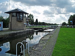
For boaters, using Sykehouse Lock can be a bit tricky. The lock is automatic, but you have to open the swing bridge over it by hand first. Only then can the automatic system work.
The area around the canal doesn't have many big towns. There are two main villages: Sykehouse at the northern end and Kirk Bramwith at the southern end. For much of its length, the path next to the canal is part of the Trans Pennine Trail. This is a long path for walking and cycling.
Places to See
| Point | Coordinates (Links to map resources) |
OS Grid Ref | Notes |
|---|---|---|---|
| Junction with Aire and Calder Canal | 53°39′40″N 1°00′57″W / 53.6611°N 1.0157°W | SE651187 | |
| Sykehouse lift bridge | 53°38′55″N 1°01′36″W / 53.6485°N 1.0268°W | SE644173 | |
| Sykehouse lock | 53°38′15″N 1°02′09″W / 53.6375°N 1.0358°W | SE638160 | |
| Top Lane lift bridge | 53°36′21″N 1°03′45″W / 53.6058°N 1.0626°W | SE621125 | |
| River Don aqueduct | 53°35′42″N 1°04′20″W / 53.5949°N 1.0723°W | SE615113 | |
| Junction with River Don Navigation | 53°35′25″N 1°04′33″W / 53.5904°N 1.0757°W | SE612108 |
 | Georgia Louise Harris Brown |
 | Julian Abele |
 | Norma Merrick Sklarek |
 | William Sidney Pittman |


