
Immingham facts for kids
Quick facts for kids Immingham |
|
|---|---|
 Queens Road, Immingham |
|

Immingham
|
|
| Population | 9,642 (2011 Census) |
| OS grid reference | TA178145 |
| • London | 150 mi (240 km) S |
| Unitary authority | |
| Ceremonial county | |
| Region | |
| Country | England |
| Sovereign state | United Kingdom |
| Post town | IMMINGHAM |
| Postcode district | DN40 |
| Dialling code | 01469 |
| Police | Humberside |
| Fire | Humberside |
| Ambulance | East Midlands |
| EU Parliament | Yorkshire and the Humber |
| UK Parliament |
|
Immingham is a town in North East Lincolnshire, England. It sits on the south-west bank of the Humber Estuary, about 10 kilometers (6 miles) northwest of Grimsby.
For a long time, Immingham was a very small place. But in the early 1900s, the Great Central Railway started building Immingham Dock. This huge dock, along with new industries after World War II, helped Immingham grow into an important town in the 20th century. In 2019, the Port of Immingham & Grimsby was the busiest port in the United Kingdom, handling 54 million tonnes of cargo!
Contents
Exploring Immingham's Geography
Local Council Areas
The Immingham Ward is a local area within the North East Lincolnshire Council. It includes nearby places like Stallingborough, Healing, and Habrough. In 2018, the people elected Stewart Swinburn, David Bolton, and David Watson as their local councillors. These councillors help make decisions for the community.
In 2011, about 11,507 people lived in this ward. The European route E22 passes through Immingham on the A180 and A160 roads, going through Immingham Dock.
The Civil Parish of Immingham
The civil parish of Immingham is located on the south bank of the Humber Estuary. It's about 10 kilometers (6 miles) west-northwest of Grimsby. The parish borders South Killingholme to the north-west and Stallingborough to the south-east. It also touches Habrough and Keelby to the south-west.
This area is quite flat, with some parts near the Humber being less than 5 meters (16 feet) above sea level. The highest point is 21 meters (69 feet) in Roxton wood. Key features here are the Humber shoreline, the Immingham Dock area, and the town of Immingham itself. Major roads like the A180 and a main railway line also cross the southern part of the parish.
Long ago, there were two medieval villages in this parish that are now abandoned. One was the original village of Immingham, and the other was Roxton. In 2011, the civil parish had a population of 9,642 people.
About Immingham Town
The mayor of Immingham is Kevin Houghton. He was elected after Stefan Allan, who served as mayor before him. The mayor is a leader who represents the town.
Immingham town is a compact area, about 2.6 square kilometers (1 square mile) in size. It's located southwest of the dock. The town has a main shopping area called "Kennedy Way," where you can find stores like Tesco and Aldi. There's also a leisure center with a swimming pool and gym, plus several schools for students.
On the edge of town, there's a Knauf UK GmbH factory that makes plasterboard.
Getting Around Immingham
In the past, Immingham had two railway lines. The Barton and Immingham Light Railway mostly carried goods to and from the dock. The Grimsby and Immingham Electric Railway took passengers between the town and the dock. Both of these lines closed by the early 1960s.
Today, the closest train stations are at Habrough and Stallingborough. These are on the Barton line. You can also catch a bus service, operated by Stagecoach East Midlands, that connects Immingham with Grimsby every half hour.
Media and News
For local news and TV shows, people in Immingham can watch BBC Yorkshire and Lincolnshire and ITV Yorkshire. TV signals come from the Belmont transmitting station.
Local radio stations include BBC Radio Humberside, Hits Radio East Yorkshire & North Lincolnshire, Hits Radio Lincolnshire (on DAB), and Greatest Hits Radio Yorkshire. The local newspaper that covers Immingham is the Grimsby Telegraph.
Immingham's History
What's in a Name?
The name Immingham is believed to mean "the Homestead of the people of Imma." It comes from old words like "Imma," "inga," and "ham."
The town was called Imungeham in the Domesday Book (a very old record from the 11th century). Around 1115, it was written as Immingeham. The ending "-ham" is from the Anglo-Saxon language.
Early Days of Immingham
Immingham is mentioned as a manor (a large estate) in the 11th-century Domesday Book.

Saint Andrew's Church is very old, with much of it built in the 13th century. Some parts of the church might even be from the 11th or 12th century. The tower was added later, in the 16th or 17th century. The church also has a decorated font from the 15th century and the remains of an old stone cross outside.
Archaeologists have found signs of a medieval settlement near the church. They also found evidence of saltmaking in the area. Records from the Domesday Book and a 12th-century document mention a saltmaking site here.

In 1608, Immingham played a small part in the story of the Pilgrim Fathers. These people were trying to sail to the Netherlands for religious freedom. Their ship had to land in Immingham because of bad weather. The women in the group were allowed to sleep in the village church. However, the authorities found out and arrested the women, while the men escaped. Luckily, a public protest helped free the women, and they were able to rejoin their families and continue their journey.
Later, in the medieval period, Immingham's population decreased. This might have been because the haven (a small harbor) leading from the Humber became filled with silt, making it harder for ships to reach.
Some old buildings still stand, like Churchfield Manor (from the late 1600s/early 1700s) and Belmont Cottage (early 1800s). In 1840, the "Ings" (meadows) at Immingham were enclosed. A coastguard station was built in 1850. The Great Grimsby and Sheffield Junction Railway opened in 1845 and passed through the parish south of Immingham.
By the 1870s, Immingham had a population of 237 people. Most of the land was good for grazing animals. The village had the church and also two Methodist chapels.
Immingham from 1900 to 1950

The building of Immingham Dock started in 1906. King George V officially opened it on July 22, 1912. This huge dock covered about 400 hectares (1,000 acres) of land, with 18 hectares (45 acres) of water. To help with the new port, some unique houses were built with wood frames and corrugated iron. Some of these "tin houses" from 1907 are still standing today.
During the First World War, Immingham was a base for British submarines. There were also anti-aircraft guns in the town to protect against air attacks.
By the 1920s, the port had become much more important than the old village. People saw Immingham mainly as a busy commercial port. By the mid-1930s, the village had grown so much that a new school was needed, and a comprehensive school opened in 1936.
During the Second World War, two brave men, John Dowland and Leonard Harrison, received the George Cross medal. They bravely defused a bomb that had landed on a grain ship in Immingham Dock in February 1940. Anti-aircraft batteries were placed around the dock to protect it during the war.
The Humber Force, a part of the British navy, was also based at Immingham during the war.
Immingham from 1950 to Today

At the start of the 1950s, Immingham was still quite small. But after the Second World War, new industries began to develop along the South Humber bank. This led to a lot more growth for the town. By 1981, the population had grown to 11,506, making it the fourth-largest town in North Lincolnshire.
The town expanded with new buildings like the Eastfield County Junior School (1970) and an expanded comprehensive school (1973). A shopping center called "Kennedy Way" was built in 1965–67. Also, 18 blocks of five-story flats were built by George Wimpey starting in 1965. A Civic Centre also opened in 1965.
Many new houses were built, especially in an area called Pilgrim Avenue. The town grew steadily towards the old Immingham village. The main growth of the new town slowed down by the mid-1980s.
The Immingham Dock railway station closed in 1969. The Immingham Museum was started in 1970. In 1979, the Kennedy Way shopping center was made bigger to add more shops. The local council also opened a Sports Center in 1980.
In 2007, Immingham School changed its name to Oasis Academy Immingham.
In 2014, the supermarket chain Aldi bought a site at Kennedy Way and opened a new store in May 2015.
Several banks and building societies in the town closed their branches between 2009 and 2010.
In 2012, plans were approved for a new large Tesco store near the Immingham Civic Centre. Work on this £10 million Tesco supermarket began in 2014, which meant the old Immingham Sports Centre was demolished. A new sports facility was planned at Oasis Academy Immingham. Other stores like Poundstretcher and B & M opened in the new development in late 2014. A new "Multi User Games Area" (MUGA) for sports opened in March 2015.
However, in January 2015, Tesco decided to stop developing 49 new stores, including the one in Immingham, due to falling sales. The built but unopened store was put on hold. Later, on September 20, 2018, Tesco opened one of their first Jack's stores in this unused building.
.jpg)
In early 2016, work began to rebuild the Immingham Civic Centre. The goal was to bring many public services together in one place. This includes the Immingham Town Council, North East Lincolnshire Council offices, Humberside Police offices, Shoreline (a housing agent) offices, a Library, and the Immingham museum. The museum shows how the Great Central Railway helped build the docks and local railway network. The museum is open from Wednesday to Saturday, from March to November.
How Immingham is Governed
| Immingham Town Council | |
|---|---|
| Type | |
| Type |
Town Council
|
| Leadership | |
|
Mayor
|
Cllr Kevin Houghton
|
|
Town clerk
|
Andy Hopkins
|
| Structure | |
| Seats | 15 Councillors |
|
7 / 15
|
|
|
6 / 15
|
|
|
2 / 15
|
|
| Elections | |
| Plurality-at-large | |
|
Last election
|
7 May 2019 |
|
Next election
|
2 May 2023 |
| Meeting place | |
| Civic Centre, Immingham | |
Immingham is governed at different levels. The lowest level is the Immingham Town Council. Immingham has three electoral wards, and a total of 15 councillors are elected to the Town Council. These councillors are in charge of things like burial grounds, allotments (small garden plots), play areas, and some street lighting. Elections for the town council happen every four years. The Mayor of Immingham is chosen by the town councillors each year.
At the county level, Immingham is part of the North East Lincolnshire Council. This council handles many local government services. These include collecting Council Tax, running libraries, providing social services, processing planning applications, and managing waste collection. They are also responsible for local education.
In the United Kingdom Parliament, Immingham is part of the Brigg and Immingham constituency. This area is represented by a Member of Parliament (MP), currently Martin Vickers from the Conservative Party. The constituency also includes other towns like Barton-upon-Humber.
Roxton: A Lost Village
There was once a village called Roxton near Immingham. We know about this medieval village from old earthworks (changes in the ground from past buildings) and cropmarks (patterns in crops that show buried structures). There might have also been a moated enclosure (a fortified area surrounded by water) between Immingham and Roxton, but it is no longer visible.
Notable People from Immingham
- Sean Storey, a professional snooker player.
Images for kids
-
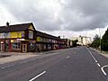
Queens Road, Immingham
-

St Andrew's Church
-
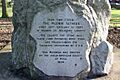
Pilgrim Fathers' memorial
-

"Tin house" Iron clad housing built 1907. (2009)
-

Kennedy Way Shopping Centre (2007)
-
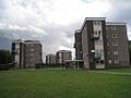
The Washdyke Estate was built by George Wimpey in the 1960s and demolished from 2017 to 2018
See also
 In Spanish: Immingham para niños
