
South Killingholme facts for kids
Quick facts for kids South Killingholme |
|
|---|---|
 South Killingholme village |
|

South Killingholme
|
|
| Population | 1,108 (2011 Census) |
| OS grid reference | TA178145 |
| • London | 150 mi (240 km) S |
| Unitary authority | |
| Ceremonial county | |
| Region | |
| Country | England |
| Sovereign state | United Kingdom |
| Post town | IMMINGHAM |
| Postcode district | DN40 |
| Dialling code | 01469 |
| Police | Humberside |
| Fire | Humberside |
| Ambulance | East Midlands |
| EU Parliament | Yorkshire and the Humber |
| UK Parliament |
|
South Killingholme is a village and civil parish in North Lincolnshire, England. In 2011, about 1,108 people lived here.
For a long time, South Killingholme was mostly farmland with only a few people living there. The village was quite small. But in the 1960s, things changed a lot! Big factories and industries started to appear along the Humber bank. One of the first was the Humber Oil Refinery, built in the late 1960s. As these industries grew, so did the village. By the early 1970s, South Killingholme looked much like it does today.
The nearby Port of Immingham also grew, spreading into the parish from the 1970s. This included the Immingham Bulk Terminal (built in 1970) and later the Immingham Gas Jetty (built in 1985). In 2004, a large power station, now called Immingham Power Station, was built next to the oil refinery.
Today, about half of the land in South Killingholme is used for heavy industry, like storing and refining oil, and generating power. The other half is still used for farming. South Killingholme is the only village in the area and is located right in the middle of it all.
Exploring South Killingholme's Location
The area of South Killingholme stretches from the edge of the Humber Estuary southwest through the village itself. It's about 6 kilometers (3.7 miles) long and 2 kilometers (1.2 miles) wide. In 2001, 1,047 people lived here, and by 2011, the population grew to 1,108. The parish is part of the Ferry ward in North Lincolnshire.
The southeastern and southern borders of the parish are next to Immingham and Habrough. This border follows a main drain that leads to South Killingholme Haven. The southwestern edge reaches Ulceby railway station, which is about 2 kilometers (1.2 miles) east of the village of Ulceby. Here, the parish borders Brocklesby and Ulceby, often following the Skitter Beck canal. The northwestern border is entirely with North Killingholme. It runs through the Lindsey Oil Refinery and reaches the Humber Estuary between the north and south Killingholme havens.
Most of the parish is low-lying land. It rises from less than 5 meters (16 feet) above sea level near the Humber bank to a high point of 17 meters (56 feet) in the southwest, south of the village. Half of the land is used for farming, with some tree plantations. The land is drained by man-made ditches. The only main place where people live is the village of South Killingholme, which is near the center of the parish.
The rest of the parish is used for factories and transport. Northeast of the village is the Humber Oil Refinery, and part of the Lindsey Oil Refinery is also in the parish. Near the Humber, the Port of Immingham has expanded into the area. This includes the western part of the Immingham Bulk Terminal, also known as the Humber International Terminal, and the Immingham Gas Terminal. A special railway line for freight to the docks runs through the parish from a junction near Ulceby station. To the northwest along the banks, there's the Killingholme gas jetty and a storage facility. Three lighthouses, built in the 1800s, are located on the Humber bank near the oil storage area.
The A1077 and A160 roads pass through the parish. They connect to the A180 and go through the village, leading to Immingham Dock.
Guiding Ships: The Lighthouses
| Location | South Killingholme Lincolnshire England |
|---|---|
| Coordinates | 53°38′50″N 0°13′08″W / 53.647198°N 0.218865°W |
| Year first constructed | 1836 (first) |
| Year first lit | 1876 (current) |
| Construction | brick tower |
| Tower shape | tapered cylindrical tower with balcony and lantern |
| Markings / pattern | red tower, white lantern dome |
| Height | 24 metres (79 ft) |
| Focal height | 21 metres (69 ft) |
| Range | 3 nmi (5.6 km; 3.5 mi) |
| Characteristic | Oc R 4s. |
Three lighthouses were built on the Humber bank in the 1800s to help guide ships:
- Killingholme High Lighthouse (first built in 1831, rebuilt in 1876)
- Killingholme South Low Lighthouse (built in 1836)
- Killingholme North Low Lighthouse (built in 1851)
The High and South Low lighthouses worked together to guide ships coming from the south. The High and North Low lighthouses worked together for ships coming from the north. The North Low Light has not been used since 1920.
In the early 1900s, there were also brick factories northwest of South Killingholme Haven.
A Look Back: South Killingholme's History
We know people lived near South Killingholme a very long time ago, even back in the Iron Age and Roman Britain times. There's also evidence of activity continuing into the Middle Ages. It's believed there was once a moated manor (a type of fortified house) north of the modern village, possibly from the Norman period or even earlier, but nothing is left of it today.
The name "Killingholme" comes from Swedish and means 'Goat kid islet'. There are many places with similar names in Sweden and Finland.
One old building still standing is "The Nook," a timber-framed house near the church that dates back to the 1600s or even earlier.

A Baptist church was first built in 1747 and then rebuilt in 1792. It's now a protected building.
The Grimsby and New Holland Railway opened in 1848, and Ulceby railway station opened the same year, about 3 kilometers (1.9 miles) west of the village. By 1886, South Killingholme had a school, a post office, and Methodist churches. It had about twenty homes spread out along Greengate Road, Town Street, and School Road. By the early 1900s, the Cross Keys Inn was built, and by the 1930s, a few more homes were added.
By 1872, South Killingholme had 574 people, which was about three times more than North Killingholme. Besides the Baptist church, there were also Wesleyan and Primitive Methodist churches in the village.
The Barton and Immingham Light Railway opened around 1910. It ran through the parish north of the village, close to the Humber bank. Killingholme railway station opened in 1910, about 3 kilometers (1.9 miles) northeast of the village. This railway line connected to the Humber Commercial Railway, which also ran through the parish. Both were built to help with the development of Immingham Dock.
By 1930, a factory that made fish meal and oil was built between the lighthouses and brickworks. It had its own jetty on the Humber. Both the fish factory and the brickworks were connected to the new light railway. Some terraced houses, called Marsh Row, were also built near Marsh farm. Not much changed in the parish from the 1930s through the 1950s.
During the 1960s, the area saw huge industrial growth, especially with the Humber Refinery being built. Roads were greatly improved, and existing ones like the A160 were made wider. New railway sidings were built for the oil refineries. On the Humber banks, the old fish meal and brick factories closed down. A new jetty for importing oil and gas, called the Killingholme Gas Jetty, was built near the lighthouses, along with a storage facility. Train services on the Barton to Immingham Line stopped in 1963.
At the same time as the factories grew, the village of South Killingholme also got much bigger. By the mid-1960s, the number of houses in the village had increased a lot, with new homes built along Greengate Lane, Town Street, Top Road, and other places. By the early 1970s, the area between Greengate Lane, Top Road, School Road, and Town Street was filled with new homes. New housing estates and roads, like St Deny's Road, were built north of Greengate Lane. After that, housing development slowed down, with only a few more houses built on Lancaster Road up to 2006.
The Port of Immingham continued to expand, and some storage facilities for the Immingham Bulk Terminal were built west of South Killingholme Haven in 1970. Another gas jetty, the Immingham Gas Jetty, was built between the existing jetty and the bulk terminal. In the early 2000s, the bulk terminal was greatly expanded further west into the parish. This new part is known as the Humber International Terminal.
On November 23, 1981, a small tornado hit the South Killingholme area. This was part of a record-breaking day for tornadoes across the UK.
In 2004, ConocoPhillips built a large power station, the Conoco Philips Power Station (also known as Immingham Power Station), next to their Humber Refinery. In 2005, the same company planted "Mayflower Wood," a 120-acre (0.49 km2) area with over 60,000 trees and shrubs. In 2009, the power station was made even bigger.
In 2015, work began on a big road improvement project called the "A160/A180 Port of Immingham Improvement." This project aimed to make the A160 road a dual carriageway (two lanes in each direction) and add new junctions. As part of this, a new road bridge was built on Town Street over the dual carriageway, connecting both sides of South Killingholme.
In August 2024, plans were announced for three large data centers and a nearby greenhouse to be built next to the A160 in South Killingholme.
Images for kids
-
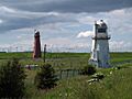
Killingholme High (red) and South Low (white) lighthouse (2008)
-
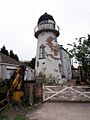
Killingholme North Low lighthouse (2006)
-
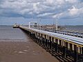
South Killingholme Oil Jetty (2008)
-
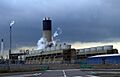
Conoco Philips power station (2006)
-
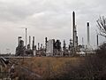
Humber oil refinery (2009)


