
Middleton, Leeds facts for kids
Quick facts for kids Middleton |
|
|---|---|
 Middleton Park Avenue |
|

Middleton
|
|
| Population | 26,228 (Ward. Middleton Park. 2011) |
| OS grid reference | SE2927 |
| Metropolitan borough | |
| Metropolitan county | |
| Region | |
| Country | England |
| Sovereign state | United Kingdom |
| Post town | LEEDS |
| Postcode district | LS10 |
| Dialling code | 0113 |
| Police | West Yorkshire |
| Fire | West Yorkshire |
| Ambulance | Yorkshire |
| EU Parliament | Yorkshire and the Humber |
| UK Parliament |
|
Middleton is a lively suburb located in Leeds, West Yorkshire, England. It sits on a hill about 4 miles (6.4 km) south of Leeds city centre. Historically, Middleton was a small village in the West Riding of Yorkshire.
Middleton is part of the Middleton Park area within Leeds City Council. It is also in the Leeds South parliamentary area. In 2011, the population of Middleton Park ward, which includes Belle Isle, was 26,228 people.
People lived in Middleton even before the Norman Conquest. It was mentioned in the Domesday Book in 1086 as Mildetone. The area grew as a large estate, and its owners soon discovered and started mining coal.
During the start of the Industrial Revolution, a wooden track was built to carry coal from the mines to Leeds. Later, a special iron railway was designed by John Blenkinsop, a local coal manager. The first steam-powered train for this railway was built by Matthew Murray in Holbeck. The coal mines in Middleton operated until 1968. Today, the historic railway is still preserved and run by a trust, celebrating over 200 years of operation.
Middleton Park is a large green space that was once part of the old estate. It has a lot of very old woodland. Some parts of the park, where coal was mined long ago, are now protected as a "scheduled ancient monument." This means they are important historical sites.
The village first grew along Town Street. A school, chapel, and church were built there in the 1800s. In 1920, Leeds Council bought the land. They built a large council housing estate on the flatter land to the south. This completely changed Middleton from a rural village to a busy residential area.
Early transport included a tram line, and the Leeds Ring Road was built near Middleton. After the coal mine closed, the area faced some challenges. Today, the Middleton Regeneration Board is working to improve the area for everyone.
Contents
History of Middleton
Middleton's name comes from old English words meaning "middle settlement" or "farm." It was likely a middle stop on the road between Morley and Rothwell.
Early Discoveries and Settlements

Tools made of flint and bronze have been found here. This shows that people lived in Middleton during the Stone Age and Bronze Age. Evidence of Roman activity was also found in 1607 and 1823.
The Domesday Book mentioned Middleton, noting it had three "carucates" of land. Much of this land was covered in woodland. The land was given to Ilbert de Lacy, who owned a castle in Pontefract. Middleton Park is what remains of this large estate from after the Norman Conquest.
In the 1200s, there was a big argument about the border between Middleton and Beeston. This area was covered in thick woods. The dispute was settled in 1209, and a boundary bank and ditch were built. You can still see parts of this old boundary in Middleton Woods today.
Owners of Middleton Estate
Over the centuries, different families owned the Middleton estate. The Leigh family held the land for a long time, from the 1300s until 1697. Then, Anne Leigh married Ralph Brandling, whose family owned coal mines in Durham.
William Gascoigne, who invented the micrometer, lived at New Hall in Middleton. He died fighting in a battle in 1644.
In the 1700s, the Brandling family built Middleton Hall on Town Street. They mostly lived in Durham, but their agent, John Blenkinsop, lived there in 1809. Sadly, the hall was destroyed by fire in 1962. The old gatehouse for Middleton Hall is still standing today on Town Street.
In 1760, the Brandlings built a new home called Middleton Lodge. It was located in what is now Middleton Park. Members of the family lived there until 1860. The Brandlings later sold the estate in 1862. Middleton Lodge was used as the headquarters for Middleton Golf Club before it was taken down in 1996.
Industrial History
Middleton has a rich history of coal mining. You can still see signs of early mining in Middleton Woods, like old shaft mounds and tracks.
Early Coal Mining

Before the 1600s, miners dug "bell pits" or horizontal tunnels called "adits" into the hillsides. These were where the coal seams were close to the surface. In 1669, Frances Conyers of New Hall had "cole pits" in Middleton. These early pits were small and often worked for only a short time.
Later, "gin pits" were used, where horses turned a machine to pull coal out of deeper shafts. These deeper mines had brick-lined shafts and wooden structures above ground. This type of mine was active when the Brandling family took over the estate.
Deep mining became possible with the invention of steam engines. These engines could pump water out of the mines, keeping them dry. This allowed miners to dig much deeper for coal. In 1780, a Newcomen engine was installed in Middleton. By 1808, the mine employed 90 coal cutters and 60 coal transporters. The demand for coal grew as Leeds and its industries expanded.
The Middleton Railway

The Middleton Railway started in 1758. It is the oldest railway in Britain that has been running continuously since it was set up by an act of Parliament. The railway, owned by Charles Brandling, first used horses to pull wooden wagons. It linked the coal mines in Middleton to Leeds.
In 1810, John Blenkinsop, the manager for the Brandlings, looked for cheaper ways to move coal. He designed a special "rack railway." Matthew Murray then built the first Middleton Railway steam locomotive, called "Salamanca." Its first journey was a big success in 1812. The Middleton Railway locomotives had a toothed wheel that fit into a rack on the side of the rail. This gave them better grip for pulling heavy coal wagons.
Mining Conditions and Closure
Before 1840, women and children also worked in the coal mines. Accidents were common. The worst disaster happened in 1825 at the Gosforth Pit. An explosion of firedamp (a dangerous gas) killed 24 people. The oldest was 48, and the youngest was just seven years old.
Broom Pit was the deepest mine in Middleton, reaching 810 feet (247 meters) down. It was also the longest-lasting. In 1896, over 600 workers were employed in Middleton's mines. By 1923, only Broom Pit was still working, employing over 1,000 men. It supplied coal for cooking, gas, and homes, as well as clay for brickworks.
When the mines were taken over by the government in 1947, the number of workers had dropped. Operations at Broom Pit finally ended in 1968 because the mine was no longer producing enough coal.
Middleton in the 20th Century
In 1919, the land around Middleton Lodge was rented by Leeds Council. It became a public park. The area changed a lot after April 1, 1920, when Middleton became part of the County Borough of Leeds.
Leeds Council bought land to build a "vast low-density corporation built cottage estate." This meant many new homes were built, using bricks from the local clay works. By 1934, 2,377 council houses had been built. The estate was seen as a "garden suburb," but residents sometimes found it far from shops and services.
More social housing was built in the 1960s. After 1972, a large private housing estate was built at Sharp Lane. Later, 1,300 houses were built at Leeds New Forest Village after 2005.
Local Governance
Middleton was once a small area connected to Holy Trinity Church in Rothwell. It became its own church area after 1849. From 1866 to 1920, it was a "civil parish," which is a local government area.
Middleton is now in the Middleton Park electoral ward. It is represented on Leeds City Council by three councillors. These councillors belong to the Social Democratic Party (SDP). Before 2022, the area had only Labour Party councillors.
The Middleton Park ward is part of the Leeds Central parliamentary area. For the 2024 general election, this area will become part of the Leeds South constituency.
Geography of Middleton
Middleton is about 4 miles (6.4 km) south of Leeds city centre. It sits on a hill, covering most of a flat area called a "plateau." This plateau drops steeply to the west and in the park to the north. From the park, you can see wide views towards the city centre.
The highest point in Middleton is about 140 meters (459 feet) above sea level. The land beneath Middleton has coal seams and fireclay. There are also layers of sandstone and shale.
The area of Middleton covers about 1700 acres (6.9 km²). About 450 acres (1.8 km²) are woodland, known as Middleton Woods. This is the largest area of ancient woodland left in Leeds. The old village grew in a line along Town Street, which runs west to east along a ridge. The main housing estate is on flatter land to the south.
Middleton is surrounded by three major motorways: the M62 motorway to the south, the M1 to the east, and the M621 to the north.
 |
Churwell | Beeston, Leeds | Belle Isle, Leeds | |
| Morley, West Yorkshire | Rothwell | |||
| Batley, Dewsbury | East Ardsley | Wakefield |
Population of Middleton
In 2010, the Middleton Park ward, which includes Belle Isle, had 27,487 residents. About 21.5% of these residents were aged 15 or younger.
Most residents in 2001, about 96.3%, identified as white British. About 71.6% said they were Christian, and over 18% said they had no religion. Many homes in Middleton are in the lowest Council Tax bands.
Population Change Over Time
| Population change in Middleton 1881–1911 | |||||||||||
|---|---|---|---|---|---|---|---|---|---|---|---|
| Year | 1881 | 1891 | 1901 | 1911 | |||||||
| Population | 1,134 | 1,236 | 1,268 | 1,207 | |||||||
| Middleton CP/Tn Parish-level Unit | |||||||||||
Economy and Services

After the Broom Pit coal mine closed in 1968, Middleton faced some economic challenges. Today, Middleton is mainly a residential area. The Middleton Regeneration Board was set up to help improve the area and create more jobs.
The St Georges Centre is a modern building in Middleton. It offers many services, including health care, a library, and a local housing office.
Middleton has two main shopping areas. At Middleton Park Circus, you can find an Aldi supermarket, a Sainsburys Local, a Boots chemist, and a Post Office. There are also several smaller, independent shops. In 2014, Asda opened a large supermarket nearby, creating over 300 jobs.
Important Landmarks

Middleton Park was once the private land of the lords of Middleton. Since 1919, it has been a public park. It covers almost a square mile (630 acres or 2.5 km²). About 200 acres (0.8 km²) of the park are ancient woodland. The park also has a small lake, recreational areas, and a golf course. The land where the Broom Pit coal mine used to be is now part of the park.
Two areas of the park are protected as "scheduled ancient monuments." These include old tracks that are now footpaths, earthworks, and remains of old mine workings.
The Middleton Railway is a special heritage steam railway. It runs from its main building in Hunslet to Park Halt. Volunteers operate the railway. You can reach Park Halt from Middleton by following a footpath that was once an old coal track. In 2012, the railway celebrated 200 years of using steam engines!
On Town Street, you can see a row of old brick cottages called Top of the town. These were built in the mid-1700s. The 19th-century St Mary's Church, its lych gate, and walls are all "Grade II listed buildings." This means they are historically important. In the churchyard, there is a war memorial built in 1920. Next to the memorial is a gatehouse that was once an entrance to the old hall grounds.
The tall, white concrete water tower is a distinctive landmark. It stands at the highest point of the hill, at the southwest corner of the park on Town Street.
Transport in Middleton

To serve the growing population of the council estate, the Middleton Light Railway, an electric tramway, was built in 1925. This tramway ran from Leeds through Middleton Woods. It was different from other city tram routes because it ran separately from the road. This allowed the trams to travel at higher speeds.
The tramway became a circular route in 1949, extending to Belle Isle Road. The tramway closed in 1959. Its old route through the park is now a footpath.
There were plans for a new tram system in Leeds called Leeds Supertram. These plans included a line to Middleton. However, the government stopped funding the project, so it was never built.
Public transport in Middleton is managed by West Yorkshire Metro. Several bus routes serve Middleton, operated by Arriva Yorkshire and First Leeds. These buses connect Middleton to Leeds city centre, Wakefield, Roundhay, Morley, and the White Rose Centre.
Education in Middleton
Teachers were working in Middleton village as early as 1811. A Sunday school, built by the Brandling family, started in 1833. It taught reading and writing and was also used for worship before the church was built. This school later became Middleton St Mary's C of E School. It moved to a new location in 1972.
There was once a secondary school called "Middleton Park High School." However, it closed on August 31, 1999.
Other schools in Middleton today include Middleton Primary School, which opened in the 1920s. St Philip's Catholic Primary and Nursery School opened in 1941. Westwood Primary School is another local school.
In 2012, about 69.6% of pupils in Middleton Park ward achieved good results by the end of Key Stage 2 (around age 11). By age 16, 32.8% of pupils achieved five or more good grades in their GCSEs.
Religion in Middleton
Middleton was originally a small church area connected to the larger parish of Rothwell. In 1497, a small chapel dedicated to St Mary the Virgin was built. This chapel was closed during the Reformation, but the building still exists today as a private home.

In 1845, R.H. Brandling of Middleton Lodge donated land on Town Street. This land was used to build a church and a house for the vicar. St Mary's Church was built in 1846. The church and its lych gate are both "Grade II listed buildings." The church originally had a tall spire, but it had to be removed in 1939 due to ground movement from mining. It is said that local miners either gave a week's wages or a week's work to help build the church.
As the population grew, especially after the council estate was built, two more church areas were created. In 1925, a mission church was built. The Church of St Cross was built in 1933. It became a parish church in 1935, covering about two-thirds of the Middleton housing estate.
The Belle Isle housing estate began in the 1930s. The Church of St John and St Barnabus was built there in 1939. It was officially recognized as a church in 1947 after the war.
Local Methodists reportedly met in a house on Town Street before a chapel was built in the 1860s. Middleton Methodist Chapel was built in 1896. It has a tower and a large window. The inside of the chapel is mostly unchanged. There is also a Baptist church on Middleton Park Avenue. St Philip's Roman Catholic Church is a modern building on St Philip's Avenue.
Sports and Activities
A public golf club opened in 1933 at Middleton Lodge. It has an 18-hole course within Middleton Park. Middleton Leisure Centre offers many sports and fitness activities for the community.
Middleton Park FC provides football coaching for all ages, from young children to adults. Rugby Union is played by Leeds Corinthians, who have a ground and clubhouse near the Middleton District Centre.
There are also two Crown Green Bowling clubs in Middleton. One is in Middleton Park, and the other is the Community Bowling Club on Acre Close.
Images for kids
-
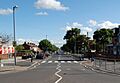
Middleton Park Avenue
-
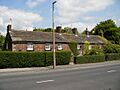
Rustic, brick-built cottages in Town Street known as Top of the town were built for the Brandlings' workers.
-

Depression or bell pit, evidence of early coal mining in Middleton Woods
-
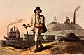
"The collier" at Middleton Colliery, in The Costume of Yorkshire by George Walker, 1814
-
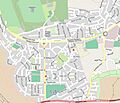
Middleton street map
-
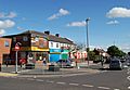
Shops at Middleton Park Circus
-
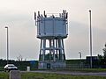
Middleton Water Tower
-
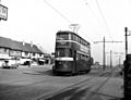
Tram on Middleton Ring Road, Lingwell Road tram stop, the terminus before the extension to Belle Isle was built in 1949.
-
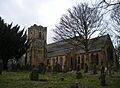
Middleton St Mary's Church built in 1847.

