
City of Leeds facts for kids
Quick facts for kids
Leeds
|
||
|---|---|---|
|
|
||
|
||
| Motto(s): | ||

Leeds shown within West Yorkshire
|
||

Leeds
Location in England

Leeds
Location in the United Kingdom

Leeds
Location in Europe
|
||
| Sovereign state | United Kingdom | |
| Country | England | |
| Region | Yorkshire and the Humber | |
| City region and ceremonial county | West Yorkshire | |
| Historic county | West Riding of Yorkshire | |
| Borough Charter | 1207 | |
| Town charter | 1626 | |
| City status | 1893 | |
| Metropolitan borough | 1974 | |
| Named for | Leeds | |
| Administrative HQ | Leeds Civic Hall | |
| Government | ||
| • Type | Metropolitan borough with leader and cabinet | |
| • Body | Leeds City Council | |
| Area | ||
| • Total | 213.0 sq mi (551.7 km2) | |
| Area rank | 84th | |
| Population
(2005 est.)
|
||
| • Total | 793,139 | |
| • Rank | 2nd | |
| Ethnicity (2021) | ||
| • Ethnic groups |
List
|
|
| Religion (2021) | ||
| • Religion |
List
42.3% Christianity
40.2% no religion 7.8% Islam 1.2% Sikhism 1.1% Hinduism 0.8% Judaism 0.4% Buddhism 0.4% other 5.8% not stated |
|
| Time zone | UTC+0 (GMT) | |
| • Summer (DST) | UTC+1 (BST) | |
| Postcode areas |
|
|
| Dialling codes |
|
|
| ISO 3166 code | GB-LDS | |
| GSS code | E08000035 | |
| ITL code | TLE42 | |
| GVA | 2021 estimate | |
| • Total | £27.9 billion | |
| • Per capita | £34,487 | |
| GDP (nominal) | 2021 estimate | |
| • Total | £30.6 billion | |
| • Per capita | £37,764 | |

.jpg)

.jpg)


Leeds, also known as the City of Leeds, is a large city in West Yorkshire, England. It's not just one big city centre, but also includes several towns like Farsley, Garforth, Guiseley, Horsforth, Morley, Otley, Pudsey, Rothwell, Wetherby and Yeadon.
Leeds is a "metropolitan borough," which means it's a large area with its own local government. It has a population of about 793,139 people (as of 2005 est.). This makes it one of the biggest cities in England by population.
The way Leeds is governed locally is managed by Leeds City Council. There are also 32 smaller councils called Parish Councils that help with local matters in some areas.
The current boundaries of the City of Leeds were set on 1 April 1974. This happened as part of a big change to local government in England. The new city was formed by joining together eleven older local government areas. These included the original City and County Borough of Leeds and other towns and districts nearby.
For its first 12 years, Leeds had two levels of local government. But since 1985, Leeds City Council has been the main authority. This means it's responsible for making local rules, setting council tax (local taxes), and deciding how money is spent in the city.
Contents
History of Leeds
How Leeds Became a City

The area known as the Borough of Leeds was first created in 1207. This happened when Maurice Paynel, who owned the land, gave a special document called a charter. This charter covered a small area near the River Aire. Over time, Leeds grew bigger.
In 1626, King Charles I gave Leeds another charter, making the whole area a borough. This meant it had more formal local government. Leeds became a full city in 1893.
Forming the Modern City
In 1974, a big change happened. The old county borough of Leeds was joined with several nearby towns and districts. These included Morley, Pudsey, Aireborough, Horsforth, Otley, Garforth, and Rothwell. Parts of other rural areas were also added.
This merger created the much larger City of Leeds we know today. It became part of the county of West Yorkshire.
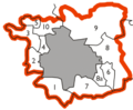
| How Leeds was formed in 1974 | |
|---|---|
The original county borough is shown in grey. Other areas that joined were:
|
 |
Geography and Location

The City of Leeds is located in the eastern foothills of the Pennines mountains. The River Aire flows through the area. Its valley, called the Aire Gap, is important for roads and railways. This helps connect Leeds with other cities to the west.
The district stretches about 15 miles (24 km) from east to west and 13 miles (21 km) from north to south. More than 65% of the land is protected "green belt" land. This means it's kept open and undeveloped.
The highest point in Leeds is about 1,115 feet (340 m) high. It's on the eastern slopes of Rombalds Moor, also known as Ilkley Moor. The lowest points are around 33 feet (10 m) in the east, near the rivers.
Leeds shares its borders with other areas. To the north and east, it borders North Yorkshire. To the south, southwest, and west, it borders other parts of West Yorkshire, like Wakefield, Kirklees, and Bradford.
How Leeds is Governed


Leeds City Council is the main local government for the Leeds district. The council has 99 councillors. These councillors are elected by people living in the city's 33 different areas, called wards. Elections happen every three out of four years.
Currently, the council is run by the Labour Party. The head of the council is Councillor James Lewis. The Chief Executive of Leeds City Council is Ed Whiting.
Because West Yorkshire doesn't have a county council, Leeds City Council is the main provider of local services. This includes things like schools, roads, and waste collection.
Most of the Leeds district is an "unparished area." This means there isn't a smaller local government level below the city council. However, there are 31 civil parishes in other parts of the district. These have their own parish councils that handle some local tasks. Some of these, like Horsforth, Morley, Otley, and Wetherby, have "town councils."
Here are some of the civil parishes in Leeds:
- Aberford
- Allerton Bywater
- Alwoodley
- Arthington
- Austhorpe
- Bardsey cum Rigton
- Barwick in Elmet and Scholes
- Boston Spa
- Bramham cum Oglethorpe
- Bramhope
- Carlton
- Clifford
- Collingham
- Drighlington
- East Keswick
- Gildersome
- Great and Little Preston
- Harewood
- Kippax
- Ledsham
- Ledston
- Lotherton cum Aberford
- Micklefield
- Parlington
- Pool
- Rawdon
- Scarcroft
- Shadwell
- Sturton Grange
- Swillington
- Thorner
- Thorp Arch
- Walton
- Wothersome
The people of Leeds are represented in the UK Parliament by ten MPs. Each MP represents a different area, or constituency, within or partly within Leeds.
People and Population
| Historical population | ||
|---|---|---|
| Year | Pop. | ±% |
| 1801 | 94,421 | — |
| 1811 | 108,459 | +14.9% |
| 1821 | 137,476 | +26.8% |
| 1831 | 183,015 | +33.1% |
| 1841 | 222,189 | +21.4% |
| 1851 | 249,992 | +12.5% |
| 1861 | 311,197 | +24.5% |
| 1871 | 372,402 | +19.7% |
| 1881 | 433,607 | +16.4% |
| 1891 | 503,493 | +16.1% |
| 1901 | 552,479 | +9.7% |
| 1911 | 606,250 | +9.7% |
| 1921 | 625,854 | +3.2% |
| 1931 | 646,119 | +3.2% |
| 1941 | 668,667 | +3.5% |
| 1951 | 692,003 | +3.5% |
| 1961 | 715,260 | +3.4% |
| 1971 | 739,401 | +3.4% |
| 1981 | 696,732 | −5.8% |
| 1991 | 716,760 | +2.9% |
| 2001 | 715,404 | −0.2% |
| Source: Vision of Britain | ||
In 2001, the City of Leeds had a population of 715,402 people. Most households were either married couples or people living alone.
Leeds is a diverse city. In 2021, about 79% of people identified as White. Other groups included Asian (9.7%), Black (5.6%), and Mixed (3.4%).

Many people in Leeds identify as Christian. There are also many Muslims, and Leeds has one of the largest Jewish communities in the UK. Some people also follow Sikhism, Hinduism, or Buddhism. About 40% of people said they had no religion.
Economy and Jobs

Leeds has a strong and varied economy. In the past, it was known for manufacturing (making things). But now, the "service sector" is much more important. This means jobs in areas like finance, retail (shops), call centres, and media.
Leeds is one of the biggest financial centres in England, outside of London. These new types of jobs have helped the city's economy grow a lot.
Education in Leeds
Leeds City Council is responsible for providing educational services in the city. They manage schools and other learning programs through their Children's Services Department.
Media and Entertainment
Television
Leeds is a hub for television broadcasting in the region.
- BBC Yorkshire has studios in Leeds.
- ITV Yorkshire (formerly Yorkshire Television) broadcasts from the Leeds Studios.
- Leeds TV also broadcasts local shows for about 37 hours each week.
Radio
You can listen to several radio stations in the Leeds area:
- BBC Radio Leeds (local BBC station)
- Heart Yorkshire
- Capital Yorkshire
- Hits Radio West Yorkshire
- Greatest Hits Radio West Yorkshire
- Community radio stations like LDC Radio, Tempo FM (for Wetherby), Drystone Radio (for Wharfedale), and Radio Asian Fever (for the Asian community).
Newspapers
Local newspapers for the area include:
- The Yorkshire Post
- Yorkshire Evening Post
- Wetherby News
- Gazette & Observer
Getting Around Leeds
.jpg)
Leeds railway station connects the city centre to the national train network. Public transport, like buses and trains, in West Yorkshire is managed by West Yorkshire Metro. This group works with local councils, including Leeds City Council, to plan transport.
Public Services
Leeds City Council manages 24 cemeteries in Leeds. The oldest ones opened in 1845, and the newest ones opened in 2013.
Twin Cities
Leeds has "twin city" or "partnership" agreements with several cities around the world. These partnerships help promote cultural exchange and friendship.
 Brno, Czech Republic
 Dortmund, Germany
 Durban, South Africa
 Hangzhou, China
 Lille, France
 Louisville, United States
- Siegen, Germany
 Kharkiv, Ukraine
Images for kids
-
Map showing how Leeds was formed in 1974.
