
Yeadon, West Yorkshire facts for kids
Quick facts for kids Yeadon |
|
|---|---|
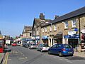
 High Street, Yeadon |
|

Yeadon
|
|
| Population | 22,233 (Otley and Yeadon Ward, 2011 census) |
| OS grid reference | SE219398 |
| • London | 205 miles (330 km) |
| Metropolitan borough | |
| Metropolitan county | |
| Region | |
| Country | England |
| Sovereign state | United Kingdom |
| Post town | LEEDS |
| Postcode district | LS19 |
| Dialling code | 0113 |
| Police | West Yorkshire |
| Fire | West Yorkshire |
| Ambulance | Yorkshire |
| EU Parliament | Yorkshire and the Humber |
| UK Parliament |
|
Yeadon is a town located in West Yorkshire, England. It is part of the larger City of Leeds area. Most of Yeadon is in the Otley and Yeadon area for local elections. It is also part of the Leeds North West area for national elections. A small part of the town is in the Guiseley and Rawdon area.
Leeds Bradford International Airport is right next to the eastern side of Yeadon.
Contents
- Exploring Yeadon's Past
- Yeadon's Location and Landscape
- Getting Around Yeadon
- Places of Worship in Yeadon
- Important Buildings and Landmarks
- How Yeadon is Governed
- Shopping and Services in Yeadon
- Sports in Yeadon
- Yeadon's Economy and Jobs
- Famous People from Yeadon
- Location Grid
- Images for kids
- See also
Exploring Yeadon's Past
How Yeadon Got Its Name
The name Yeadon comes from old English words. These words mean "steep hill." This makes sense because a part of the High Street has been called "the Steep" for hundreds of years. Yeadon was one of three early hill settlements, along with Rawdon and Baildon. Some people think Yeadon was used for burials and religious events long ago.
Yeadon in Medieval Times
Yeadon was once part of the Kingdom of Elmet. Later, the Anglo-Saxons took over. They divided Yeadon into two parts: Yeadon and Nether Yeadon. Each part had its own Saxon lords. This division lasted until 1630. After the Danish conquest of Yorkshire, Yeadon became part of the Skyrack area.
After the Normans took control, the two parts of Yeadon were given to new families. The Domesday book says Yeadon was about 328 acres. Much of the land later belonged to Bolton Priory and Kirkstall Abbey. These religious groups had a lot of power. In 1354, villagers won a court case against Kirkstall Abbey. They gained control of 300 acres of moorland. This land is now where Leeds Bradford Airport is located.
During this time, there were only about thirty homes in Yeadon. They were spread out in three main spots. One was where the town centre is now. Another was near the Woolpack pub. A smaller group of homes was further west. People farmed sheep and made wool into cloth. Yeadon Gill, a small stream, powered a corn mill.
Yeadon's Growth and Changes

Even with the English Civil War, Yeadon grew. Its population more than doubled in the 1600s. There were 93 hearths (fireplaces) recorded. Old land areas were turned into more efficient farms. A new mill was built. The town was no longer divided. It also had important social groups, like those helping the poor.
In the 1700s, a school was built. More stone houses replaced older, simpler cottages. A windmill and the first steam-powered mill also appeared. People had to travel far to worship at the church in Guiseley. They asked for their own church in 1714, but it wasn't built until 1844.
John Yeadon (1764–1833) was a local preacher for over thirty years. He wrote a journal about his life and the town. He and his wife had fourteen children. John led services in many nearby villages and towns. He also attended services by John Wesley, a founder of Methodism. His journal gives us a look into town life and the early Methodist Church.
In the 1800s, Yeadon's population grew very fast. It went from 1,695 people in 1801 to 7,396 in 1891. Yeadon changed from a farming town to a manufacturing town. It was known for making women's clothing. To help trade, a new road (now the A65) was built in 1827. The railway arrived in the 1840s. In 1845, Yeadon became separate from Guiseley. By 1853, it had gas from a local company. The water became polluted by waste from other towns. Yeadon won a court case about this in 1868. The Yeadon Waterworks dug a well in 1861 and started building a reservoir in 1877. The town's health board was set up in 1863. They built a cemetery in 1876. In 1880, Yeadon got its own "Yeadon Town Hall and Mechanics' Institute."
Yeadon in the 20th Century and Beyond
In the early 1900s, there were many worker protests. A big lockout and hunger marches happened in 1913. As a result, the working week in textile mills became shorter. Workers also got a pay raise. In 1937, Yeadon became part of the Aireborough district. It was the largest town in this district.
Yeadon's Location and Landscape
The main part of Yeadon is on a hill that slopes towards the Aire valley. The A65 road is to the southwest and the A658 road is to the southeast. South of where these roads meet are Nether Yeadon and Little London. To the west of the A65 is New Scarborough, with many old houses.
Nunroyd Park is a public park to the northwest. It creates a green space between Yeadon and Guiseley. This park used to be the home and land of a mill owner. Before that, it was parkland for a nunnery.
You can still see signs of the medieval settlement. Fields to the north in Yeadon Banks follow the old strip patterns. The streets around Town Street and Ivegate are still winding. In contrast, the 1800s saw new areas built with straight rows of houses. Many of these terraced houses are still there. There are also sites of old mills and dye works.
The ground in Yeadon is made of sandstone and millstone grit. These rocks have been dug up and used for buildings. To the north, there is clay. This clay allowed a natural lake, Yeadon Tarn, to form on the hilltop. The lake was made bigger for industrial use. Leeds Bradford Airport is on the high plateau of Yeadon Moor to the east.
Getting Around Yeadon
Yeadon used to have a railway connection from Guiseley. This line opened in 1894 but closed in 1964. Now, it's a nature path you can walk on. The railway station was near the Station Inn. It was mainly used for goods. It also served several large mills. Passenger trains were mostly for special trips. The first train from Yeadon Station in 1905 carried 500 people. The next year, trains took passengers to Blackpool. The closest train station today is at Guiseley, about 1 mile away.
Yeadon (Green Lane) was connected to Leeds by tram from 1909 until the 1950s. Today, buses serve Yeadon. Route A2 goes north to Harrogate. Routes 33, 34, and 27 go to Otley and Guiseley. The 966 goes to Guiseley. Southbound, the A2 goes to Bradford. The A3 goes to Bradford via Shipley. Routes 33, 34, and 27 go to Leeds.
Places of Worship in Yeadon
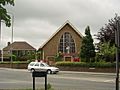
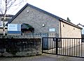
Yeadon was once part of the large Guiseley Parish. However, a church called St John the Evangelist Church was built in Yeadon in 1844. Its tower was removed in 1970 because it was unsafe. The New Life Community Church used to be St Andrew's Parish Church. It was built in 1891. There is also a Roman Catholic church (St Peter and St Paul). Yeadon has a Methodist church and a meeting hall for the Plymouth Brethren.
-
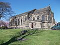
St John the Evangelist Church
-
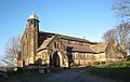
New Life Community Church
-
St Peter & St Paul Church
-
Methodist Church
-
Brethren's Meeting Hall
.jpg)


Important Buildings and Landmarks
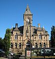
Yeadon Town Hall: A Historic Building

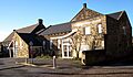
The Yeadon Town Hall and Mechanics' Institute was built in 1880. It faces north on Town Hall Square. It was designed by William Hill from Leeds. The building is made of sandstone with slate roofs. It has a central tower with a clock. The architect was chosen after a competition with over 200 entries. The building cost £5,000 to build.
Low Hall: A Charming Old House

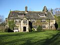
Arthur Mee, a writer, said that Low Hall is one of Yorkshire's most charming houses. It is on Gill Lane. It was a farmhouse in the 1600s, built in 1624. It was changed in the 1800s. A porch was added in 1658. The stone for the porch might have come from Esholt Priory. The house also has a secret room called a Tudor priest hole.
Yeadon Tarn: A Lake for Fun

Yeadon Tarn, also known as Yeadon Dam, is between High Street and the airport runway. During Second World War, it was drained. This was done to stop enemy planes from using its reflection to find a nearby factory.
Today, the tarn is used for sailing and fishing. You can see Mallard ducks, swans, and many Canada geese there. Next to the tarn is Tarnfield Park. This park is 17 acres and has a BMX bike track.
How Yeadon is Governed
Yeadon used to be a separate area called a "township" and "chapelry." In 1866, it became its own civil parish. In 1894, it became an urban district. On April 1, 1937, this district was combined to form Aireborough. Part of it also went to Bradford. On the same day, the parish was also combined to form Aireborough. In 1931, the parish had 7,672 people.
Yeadon, along with nearby towns Guiseley and Rawdon, was part of Aireborough Urban District from 1937 to 1974. Yeadon still has a local Rugby Union team called Aireborough RUFC. Today, Yeadon is part of the Otley and Yeadon ward of Leeds City Council. It has three local councillors. Leeds City Council manages public services in Yeadon. Yeadon is in the Leeds North West constituency for national government. This area is currently represented by Katie White from the Labour Party.
Shopping and Services in Yeadon
Yeadon has a busy town centre. Most businesses are on High Street. There is a Morrisons supermarket and other well-known shops. You can also find banks, real estate agents, and pubs. Travelodge and Premier Travel Inn hotels are located near the airport.
In Town Hall Square, there is a public library. It is part of Leeds City Council's library system. It also works as a council service centre.
Sports in Yeadon
People have played Cricket in Yeadon since about 1850. Back then, many people played on Yeadon Moor after work on Saturdays. The origins of cricket in Yeadon are not fully known. At that time, Yeadon had two teams: Topenders and Lowenders. In 1859, the teams decided to join together. They called themselves Yeadon United Cricket Club.
The famous cricketer W. G. Grace played at the Swan ground in 1877. He was bowled out for zero runs. The bowler was very happy, but his captain told him off. The crowd had paid to see Grace play!
Yeadon Cricket Club plays in the Bradford Premier League. Yeadon FC won a promotion to the FA's Wharfedale Triangle Premier League in the 2018–19 season.
Yeadon's Economy and Jobs
The Avro factory was next to Yeadon Aerodrome. From 1938 to 1946, it built many wartime planes. These included the Lancaster, Lincoln, York, and Anson. A total of 695 Lancasters were made in Yeadon.
The 2168 (Yeadon) Squadron Air Training Corps helps keep Yeadon's aviation history alive.
The national charity Epilepsy Action has its main office in the town.
Famous People from Yeadon
- Betsy Sawyer was born into slavery in Antigua. She died in Yeadon on November 24, 1839. A memorial stone was placed in Yeadon Methodist Churchyard to remember her journey to freedom.
- The former Yorkshire and England cricket captain Brian Close lived in Yeadon when he was a child.
- Moses Ayrton (1878–1950) was a Methodist minister and socialist from New Zealand. He was born in Yeadon.
Location Grid
 |
Otley | |
||
| Guiseley | Bramhope | |||
| Rawdon | Horsforth |
Images for kids
-
High Street, Yeadon
-
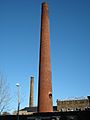
Former factory chimneys on Green Lane
-
St John the Evangelist Church
-
New Life Community Church
-
St Peter & St Paul Church
-
Methodist Church
-
Brethren's Meeting Hall
-
Yeadon Town Hall
-
Low Hall
-

Yeadon Tarn
See also
 In Spanish: Yeadon para niños
