City of Wakefield facts for kids
Quick facts for kids
City of Wakefield
|
||
|---|---|---|
| Wakefield | ||
|
||
|
||

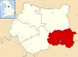
Wakefield shown within West Yorkshire
|
||
| Sovereign state | United Kingdom | |
| Country | England | |
| Region | Yorkshire and the Humber | |
| Ceremonial county | West Yorkshire | |
| Founded | 1974 | |
| Admin. HQ | Wakefield | |
| Government | ||
| • Type | Metropolitan borough, City | |
| Area | ||
| • Total | 130.7 sq mi (338.6 km2) | |
| Area rank | 127th | |
| Population
(2005 est.)
|
||
| • Total | 348,312 | |
| • Rank | Ranked 21st | |
| • Density | 2,664.3/sq mi (1,028.68/km2) | |
| Ethnicity (2021) | ||
| • Ethnic groups |
List
|
|
| Religion (2021) | ||
| • Religion |
List
49% Christianity
41.3% no religion 3.2% Islam 5.4% not stated 0.4% other 0.4% Hinduism 0.2% Buddhism 0.1% Sikhism 0.1% Judaism |
|
| Time zone | UTC+0 (Greenwich Mean Time) | |
| • Summer (DST) | UTC+1 (British Summer Time) | |
| ISO 3166-2 | GB-WKF | |
| ONS code | 00DB (ONS) E08000036 (GSS) |
|
| NUTS | 3 | |
| Website | wakefield.gov.uk | |
Wakefield, also known as the City of Wakefield, is a special area in West Yorkshire, England. It's a 'metropolitan borough' and has 'city status'. The main town, also called Wakefield, is where the local government offices are. In 2011, about 325,837 people lived here.
The area includes five main towns: Castleford, Featherstone, Knottingley, Normanton, and Pontefract. Other towns are Hemsworth, Horbury, Ossett, South Elmsall, and South Kirkby. The local government, called Wakefield Council, runs the city and district from County Hall. In 2010, Wakefield was named the third most musical city in the UK by PRS for Music.
Contents
Wakefield's Economy and Jobs
The towns and villages in the Wakefield District are getting better economically. This is partly because of the growing economy in nearby Leeds. More people are now commuting to Leeds from the Wakefield area. Also, people are recognizing the value of undeveloped land.
For example, Castleford is seeing lots of new building and money invested. This is because it's located by the River Aire. It also has easy access to major roads and empty land from old mining sites that can be used for new homes. In Ossett, house prices have gone up a lot, showing the area's growth.
Even though unemployment was high in the past, Wakefield District now has lower-than-average unemployment. Some parts of the district, especially the eastern side, are still less wealthy than the western parts.
Industries in Wakefield
The district was once known for its coal-mining towns. But other industries have also been important. These include making wool, chemicals, machine tools, and glass. Horbury even had an iron works.
In 1979, there were 21 coal mines in the district. By 1984, this number had dropped to 15. Even so, Wakefield still had more mines than any other area in the country. The last two mines, Prince of Wales and Kellingley, closed in 2002 and 2015. This marked the end of the coal mining industry that was once so important here.
History of the City of Wakefield
Wakefield became a city in 1888. In 1913, it became a 'county borough'. This meant it was no longer under the control of the West Riding County Council. The current boundaries of the district were set in 1974. This happened when the old City of Wakefield joined with several other towns and districts.
These included Castleford, Ossett, Pontefract, Featherstone, Hemsworth, Horbury, Knottingley, Normanton, and Stanley. The new larger area was confirmed as a city in 1974. The local government offices are in County Hall. This building was originally for the West Riding County Council. Wakefield took it over in 1989.
Geography and Green Spaces
The Wakefield district is part of a 'green belt' region. This green belt helps stop cities and towns from growing too much and joining together. It also protects the unique feel of smaller communities. It encourages building on old industrial sites instead of new green areas.
The green belt surrounds the main Wakefield area. It also stretches into the wider district and around towns like Walton, Netherton, Featherstone, South Kirkby, South Elmsall, Hemsworth, Castleford, Knottingley, and Pontefract. Smaller villages and rural areas are also part of this protected zone. The green belt was created in 1987. In 2017, it covered about 235 square kilometers.
How Wakefield is Governed
Wakefield Metropolitan District Council governs the district. The district is split into 21 'wards'. Each ward has three councillors who represent the local people.
Councillors are usually elected for four years. Elections are staggered, so only one councillor from each ward is up for election at a time. This helps keep the council stable.
Sports in Wakefield District
The district is home to three professional rugby league teams. These are the Wakefield Trinity, Castleford Tigers, and Featherstone Rovers. Wakefield Trinity and Castleford Tigers play in the top league, the Super League. Featherstone Rovers play in the Kingstone Press Championship. All three teams have had successful periods.
There are also several amateur rugby league clubs, like Featherstone Lions and Normanton Knights. Famous rugby league players from the area include Tom Briscoe, Rob Burrow, Zak Hardaker, and Brett Ferres. The district also has two football clubs in the Northern Premier League: Ossett United and Pontefract Collieries.
Wakefield has a strong history in cricket. Former Yorkshire and England captain Geoffrey Boycott was born in Fitzwilliam. Another former England cricketer, Tim Bresnan, is from Pontefract.
Pontefract Racecourse in Pontefract is the longest continuous horse racing track in Europe. It is about 2 miles long.
Culture and Landmarks
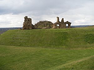
The ruins of Sandal Castle are open to visitors. They overlook Pugneys Country Park. Other important places in the Wakefield area include the National Coal Mining Museum for England. This museum is part of the European Route of Industrial Heritage.
The Yorkshire Sculpture Park and Nostell Priory are also here. Walton Hall is a Georgian mansion. It is set in what was the world's first nature reserve. This reserve was created by the explorer Charles Waterton. The house is being considered as a UNESCO World Heritage Site. Sir David Attenborough has said that Walton Hall is very important for nature conservation. He believes it was one of the first places in modern times to be protected as a nature reserve.
Two famous children's nursery rhymes have links to Wakefield. "Here We Go Round the Mulberry Bush" might have been sung by women at Wakefield prison. "The Grand Old Duke of York" may refer to the Battle of Wakefield in 1460. The words to the popular hymn "Onward Christian Soldiers" were written in Horbury.
Media in Wakefield
Television
The area gets its TV signals from the Emley Moor TV transmitter. This includes channels like BBC Yorkshire and ITV Yorkshire.
Radio
Several radio stations broadcast to the Wakefield area:
- BBC Radio Leeds
- Heart Yorkshire
- Capital Yorkshire
- Pulse 1
- Greatest Hits Radio West Yorkshire (which used to be called Ridings FM)
- Rhubarb Radio
- 5 Towns FM
Newspapers
The local newspaper for the area is the Wakefield Express.
Social Housing in Wakefield
In 2004, a big decision was made about the district's council housing. These homes were transferred to Wakefield and District Housing (WDH). WDH is an independent housing association. The idea was that they could manage repairs and maintain homes more efficiently.
This was one of the largest transfers of housing in British history. WDH is now investing a lot of money to improve the district. They are also working with partners like WMDC to build new homes.
See also
 In Spanish: Ciudad de Wakefield para niños
 | Tommie Smith |
 | Simone Manuel |
 | Shani Davis |
 | Simone Biles |
 | Alice Coachman |


