
Nomenclature of Territorial Units for Statistics facts for kids
The Nomenclature of Territorial Units for Statistics (often called NUTS) is a special system. It helps the European Union (EU) organize countries into different areas. This is mainly for collecting and comparing statistics. Think of it like a way to sort regions so that data, like population or economy, can be easily understood across different EU countries.
NUTS stands for the French phrase nomenclature d'unités territoriales statistiques. It's a geocode standard. This means it uses codes to identify specific places. The EU created NUTS to make sure everyone uses the same way to divide up countries. This makes it easier to collect and compare information.
Each NUTS code starts with two letters. These letters show the country. For example, 'FR' is for France, and 'DE' is for Germany. The only difference from other country codes is 'UK' for the United Kingdom instead of 'GB'. After the country code, numbers are added to show smaller areas.
- The first number shows the largest division.
- The second number shows a smaller division within that.
- The third number shows an even smaller division.
If there are more than nine areas at one level, capital letters are used instead of numbers. For example, '0' is used for the whole country. '1', '2', '3' and so on are used for the first set of smaller areas.
NUTS mainly covers countries within the European Union. However, some other countries like Turkey and Norway also use NUTS codes. Some places are tricky to classify. For instance, French Guiana is listed twice. It's part of France (FR930) and also listed under South America (AS13).
NUTS Levels
The NUTS system has three main levels of division. These levels help organize areas from large to small.
- NUTS 1: These are the largest divisions within a country. They often represent major regions or groups of states.
- NUTS 2: These are smaller areas within the NUTS 1 regions. They might be individual states, provinces, or large administrative areas.
- NUTS 3: These are the smallest NUTS divisions. They can be counties, districts, or groups of municipalities.
Below the NUTS levels, there are also two levels of Local Administrative Units (LAUs). These are even smaller areas, like individual towns or villages. They used to be called NUTS levels 4 and 5, but their name changed in 2003.
Not all countries have all three NUTS levels. This depends on their size and how they are organized. For example, Luxembourg is a small country. Its three NUTS divisions all refer to the entire country itself. This means Luxembourg only has LAUs below the NUTS levels.
Here are some examples of how countries are divided:
- In Germany, NUTS 1 areas are the 'States' (Länder). NUTS 2 areas are 'Regierungsbezirke' (administrative districts). NUTS 3 areas are 'Districts' (Kreise).
- In France, NUTS 1 areas are 'ZEAT' (large economic zones). NUTS 2 areas are 'Régions' (regions). NUTS 3 areas are 'Départements' (departments).
- The United Kingdom has different divisions for England, Wales, Scotland, and Northern Ireland. For England, NUTS 1 areas are 'Regions'. NUTS 2 areas are 'Groups of Counties'. NUTS 3 areas are 'Unitary authorities' or groups of districts.
The NUTS system helps gather and compare data across the EU. This data can be about things like population, jobs, or how much money people earn. By using the same system, it's easier to understand differences and similarities between regions.
Images for kids
-
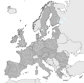
NUTS 1 regions in the EU-28
-
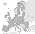
NUTS 2 regions in the EU-27
-
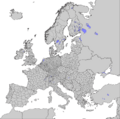
NUTS 3 regions in the EU-27
-
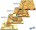
A diagram of the three main divisions of the NUTS system developed by Eurostat


See also
 In Spanish: Nomenclatura de las Unidades Territoriales Estadísticas para niños
