Windy Hill (Pennines) facts for kids
Quick facts for kids Windy Hill |
|
|---|---|
 |
|
| Highest point | |
| Elevation | 389 m (1,276 ft) |
| Geography | |
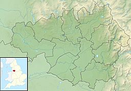
| Location | Milnrow, Greater Manchester, England |
| Parent range | Pennines |
| OS grid | SD973141 |
| Climbing | |
| Easiest route | Pennine Way |
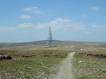
Windy Hill is a tall hill located in the South Pennines mountain range in England. It's part of Greater Manchester, specifically the area called the Metropolitan Borough of Rochdale. This hill stands about 389 meters (1,276 feet) above sea level.
What is Windy Hill?
Windy Hill gets its name because it can be quite windy up there! It is located near the town of Milnrow. The hill is part of the Pennines, which is a range of hills and mountains often called the 'backbone of England'.
The M62 Motorway and Bridge
A very busy road, the M62 motorway, passes right by Windy Hill. To make way for the motorway, a huge ditch, called the Windy Hill cutting, was dug. This cutting is very deep, about 37 meters (120 feet), and is the longest one on the entire M62 motorway.
A special bridge helps people cross over the motorway at Windy Hill. This bridge is 98 meters (320 feet) long and stands 20 meters (65 feet) above the road. It is part of the Pennine Way, a famous long-distance walking path. The bridge is built with a curved shape and strong legs to withstand very fast winds, up to 193 kilometers per hour (120 mph).
Weather and Water
Windy Hill often has snow, which stays on the ground for about 35 days each year. The area can also get foggy or covered in low clouds.
Between the hill and the motorway, a small stream called the Longden End Brook begins. Another stream, the Piethorne Brook, flows from the area into reservoirs located to the southwest.
Other Features
You can find a special stone in the cutting that marks the boundary between Greater Manchester and West Yorkshire. There is also a radio transmitter located to the east of the hill.
 | James Van Der Zee |
 | Alma Thomas |
 | Ellis Wilson |
 | Margaret Taylor-Burroughs |


