
Piethorne Brook facts for kids
Quick facts for kids Piethorne Brook |
|
|---|---|

Looking upstream to Ogden from Newhey
|
|
| Country | England |
| Physical characteristics | |
| Main source | Windy Hill |
| River mouth | River Beal, Newhey 53°35′56.57″N 2°05′44.31″W / 53.5990472°N 2.0956417°W |
The Piethorne Brook is a small river in Greater Manchester, England. It is a branch, or tributary, of the River Beal. This brook flows through a beautiful valley and has played an important role in the local history.
Contents
Where Piethorne Brook Begins
The Piethorne Brook and its smaller streams start high up on the moorland at Windy Hill. This area is on the south side of the M62 motorway. The brook's source is near Rock Stones Hill, about 415 metres (1,360 feet) above sea level.
Many small streams feed into the Piethorne Brook. Some come from Axletree Edge and Millstone Moss. These streams flow down hills like Great Whinning Gulf and Little Whinning Gulf. They all join together to form the main brook.
The Brook's Journey
The Piethorne Brook flows through a series of reservoirs built in the 1800s. These large water storage areas are important for the local water supply.
- First, it flows into Norman Hill Reservoir.
- Then, it reaches Piethorne Reservoir, where Cold Greave Brook and Tom Brook join it.
- Next, it goes through Kitcliffe Reservoir.
- Finally, it enters Ogden Reservoir, where Rag Hole Brook also adds its water.
These reservoirs, along with Hanging Lees and Rooden Reservoirs, are all found in the Piethorne Valley. After leaving Ogden Reservoir, the brook is joined by Wickenhall Brook. It then flows under Peppermint Bridge and eventually meets the River Beal in Newhey.
A Look Back in Time
People have lived near Piethorne Brook for a very long time. A Celtic spearhead, found when Piethorne Reservoir was being built, shows that people were here in the Bronze Age. Farms like Binns Farm, which was from the 1200s, were removed to make way for the reservoirs.
Old paths used by packhorses, which carried goods, crossed the brook. In the village of Haugh, near Newhey, people used to search for gold in the brook until the 1800s! The brook was also important for roads. A main road, called a turnpike, ended at the Piethorne Brook bridge.
In the 1800s, the brook's water was used to create several reservoirs. These include Norman Hill, Piethorne, Kitcliffe, Ogden, Rooden, and Hanging Lees. An old historian named Edwin Butterworth even called it the "River Haugh" on his maps around 1837. This shows how important the brook was to the area.
What's in a Name?
The name "Piethorne" might come from two words: "pie" (short for magpie, a type of bird) and "thorne" (for hawthorn, a common bush). Both magpies and hawthorn bushes are often seen in the area.
There was a mill called Salt Pye Cotton Mill near the brook. The name "salt pye" suggests a building used to store or sell salt. This was common along old packhorse routes, as salt was brought from Cheshire.
Mills Along the Brook
In the early 1800s, many woollen mills were built along the Piethorne Brook. These mills used the brook's water for power and for processing wool. Kitcliffe Farm, for example, had a fulling mill. This mill used a wooden waterwheel to clean and thicken wool. You can still see parts of this old mill today.
Later, bigger mills were built. These mills used the water more for cleaning and finishing fabrics than for power. Some of these mills included:
- Ogden Mill (for bleaching and finishing)
- Wood Mill (for processing animal hides)
- Haugh Mill (for wool and cotton)
- Salt Pye Mill (for spinning cotton waste)
Most of these mills had their own reservoirs or ponds. These were filled by the brook's water. Another mill, Lower Two Bridges Mill (later Coral Mill), also used water from the brook.
Building Reservoirs
Work on Piethorne Reservoir began in 1858 and finished ten years later. It was built to collect water from the brook. However, silt (fine dirt) from the moorland would flow into it. To fix this, Hanging Lees Reservoir was built to act as a settling pool for the silt. Norman Hill Reservoir was also built higher up.
A special stone waterfall, or cascade, was built for the brook to flow from Norman Hill into Piethorne Reservoir. When the brooks' waters were used for the reservoirs, less water flowed into the lower parts of the brook. So, Kitcliffe Reservoir and Ogden Reservoir were built. The water company was required to release one million gallons of water a day back into the brook.
Smaller Streams Joining the Brook
Several smaller streams, called tributaries, join the Piethorne Brook.
- Rag Hole Brook: This stream flows into Ogden Reservoir. Its name comes from an old local word for hoar frost.
- Wickenhall Brook: This is a major tributary. It starts high up on the moorland near the A640 road. It flows down a deep valley, passes old mill ponds, and goes under the ground in some places. It eventually joins Piethorne Brook before Ogden Mill. The name "Wickenhall" comes from "wicken," an old word for rowan or mountain ash trees, which grow in its valley.
Other Tributaries
- Haugh Brook
- Tom Brook (flows into Kitcliffe Reservoir)
- Cold Greave Brook
- Little Whinning Gulf
- Great Whinning Gulf
- Ashworth Brook
- Griffiths Brook
Images for kids
-
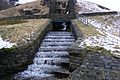
Waterfall between Norman Hill and Piethorne Reservoirs
-
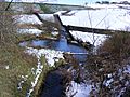
Looking upstream to Ogden Reservoir
-
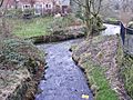
Confluence with River Beal


See also
