
Morecambe Bay facts for kids
Quick facts for kids
Designations
|
|
| Official name: Morecambe Bay | |
| Designated: | 4 October 1996 |
|---|---|
| Reference #: | 863 |
Morecambe Bay is a very large area where the sea meets the land in northwest England. It's located just south of the famous Lake District national park. This bay is the biggest area of mudflats and sand that appear at low tide in the United Kingdom. It covers a huge area of about 310 square kilometers (120 square miles).
Morecambe Bay is also home to the high brown fritillary butterfly. In 1974, a big natural gas field was found here. It was the second largest in the UK. At its busiest, this gas field provided 15% of Britain's gas supply. However, it produces less gas now.
Contents
What Makes Morecambe Bay Special?

Several rivers flow into Morecambe Bay. These include the Leven, Kent, Keer, Lune, and Wyre. Their river mouths create different land shapes, forming peninsulas within the bay.
Much of the land around the bay has been changed over time. It now includes salt marshes, which are used for farming. Morecambe Bay is also a very important place for wildlife. It has many different kinds of birds and sea creatures. There's even a special place to watch birds on Walney Island. The bay is also famous for its rich beds of cockles. Local people have collected these shellfish for many years.
The Islands of Morecambe Bay
There are seven main islands in the northern part of the bay. These are Walney, Barrow, Sheep, Piel, Chapel, Foulney, and Roa. Walney Island is much bigger than the others. Its southern tip marks the far northwest corner of the bay.
Some of these islands, like Sheep, Piel, Chapel, and Foulney, are tidal. This means you can walk to them when the tide is out. However, it's very important to be careful! The tides can come in very quickly, and there can be dangerous quicksand. Always get advice from local experts before trying to walk to these islands.
Roa Island is connected to the mainland by a raised road called a causeway. Barrow Island is also connected to the mainland. It's part of the dock system in Barrow-in-Furness.
A Look Back at Morecambe Bay's History

The wide sandy areas of Morecambe Bay were formed a very long time ago. They are what's left of a huge plain created by melting ice from the last ice age. About 11,000 years ago, the sea level was much lower than it is today.
Ancient writers mentioned this area. A Greek geographer named Claudius Ptolemy wrote about a place called Morikambe eischusis on Britain's west coast. For a long time, people debated where this place was. In 1774, the name "Morecambe Bay" started appearing on maps. It's thought the name means "curve of the sea."
Crossing the Bay: Guides and Railways

For centuries, there have been special guides appointed by the King or Queen. These "Queen's Guides to the Sands" help people cross the bay safely. Crossing the bay was very difficult. This made the land to the north quite isolated. Before railways, you could only reach it by crossing the sands or by ferry.
The Furness Railway was built in 1857. It runs along the edge of the bay, crossing the river mouths. The main railway line connecting London and Glasgow also runs briefly alongside the bay. This is the only place where this important railway line runs right next to the coast.
The bay is well-known for its dangerous quicksand and very fast-moving tides. Sadly, in 2004, a group of cockle pickers got caught by the tides, and many lost their lives. This event highlighted the dangers of the bay.
Wind Farms in the Bay
Morecambe Bay is also home to several large offshore wind farms. These include West of Duddon Sands, Burbo Bank, Walney, Barrow, and Ormonde. These wind farms help produce clean energy for the UK.
People Living Around Morecambe Bay
About 320,000 people live along the coast of Morecambe Bay. The largest town is Barrow-in-Furness, located to the west. Morecambe used to be a very popular place for seaside holidays. Barrow-in-Furness still relies on the sea for much of its economy. It is known for building ships and submarines.
Here are some of the main towns and their populations:
| Town | County | Population |
|---|---|---|
| Barrow-in-Furness | Cumbria | 56,700 |
| Morecambe | Lancashire | 34,800 |
| Fleetwood | Lancashire | 25,900 |
| Ulverston | Cumbria | 11,200 |
| Heysham | Lancashire | 8,500 |
| Grange-over-Sands | Cumbria | 4,000 |
Natural Gas from the Bay

Morecambe Bay has the UK's second-largest natural gas field. The gas is found deep underground in sandstone rock. The South Morecambe Field was discovered in 1974. Gas started flowing from it in 1985. The North Morecambe Field was found in 1976, about 8 miles (13 km) north of the first field. It began producing gas in 1994.
Both fields are managed by a company called Centrica Energy. They are located about 25 miles (40 km) west of Blackpool. The water above them is about 30 meters (98 feet) deep. The gas is found about 900 meters (2,950 feet) below the seabed. When first discovered, the fields held a huge amount of gas.
How Gas is Processed

The gas from the bay is brought to three terminals at Westfield Point in Barrow-in-Furness. These are known together as the Rampside Gas Terminal. Gas from the South Morecambe field travels through a large pipeline to its terminal.
Gas from the North Morecambe field is a bit different. It goes to a separate terminal where water, carbon dioxide, and nitrogen are removed. There's also a special pipeline for gas from the Calder field. This gas contains hydrogen sulphide, which is removed and turned into sulphuric acid for industrial use.
A power plant was built near the terminals in 1991. It uses gas to generate electricity. A support base for the gas operations is at Heysham Port. Workers usually travel to the platforms by helicopter from Blackpool International Airport.
At its busiest, the two main gas fields supplied 15% of the UK's gas. In 2006, Centrica thought there was still enough gas for another 10-15 years. Production from the South Morecambe field was briefly stopped in 2011 due to tax changes, but it started again later that year.
Future Plans: A Bridge Across the Bay?

For many years, people have talked about building a road bridge over Morecambe Bay. This idea is especially popular in the more isolated northern parts of the bay. The most recent idea is for a "green bridge." This bridge would have wind turbines and use tidal power to help the environment.
The proposed bridge would be about 12 miles (19 km) long. This would make it the longest bridge in Europe. It could also create over 10,000 well-paying jobs. The bridge would stretch from Heysham to Barrow-in-Furness, across the mouth of the bay.
This bridge would greatly reduce travel times. A trip from the M6 motorway to Barrow would drop from almost an hour to just 22 minutes. It would also use 60% less fuel. Studies are still being done to see if the bridge is possible.

The companies supporting the bridge project compare its importance to famous structures like the Øresundsbron in Denmark/Sweden and the Angel of the North sculpture. If approved, planning could be finished by 2018. Work might start the following year, costing around £8 billion.
There are also plans to build two new wind turbine sites in the bay. One will be near Walney Island and the other near Cleveleys. Together, these sites will have about 50 wind turbines.
Images for kids
-
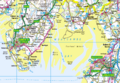
Map of the northern part of Morecambe Bay
-
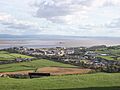
Morecambe Bay from Ulverston
-
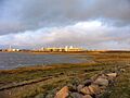
Rampside Gas Terminal
-
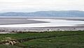
Morecambe Bay at low tide from Hest Bank, looking towards Grange-over-Sands
-
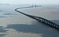
The Donghai Bridge in Shanghai, China has a similar structure to the proposed Morecambe Bay Bridge.
-
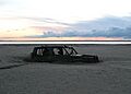
Abandoned car in Morecambe Bay, 400 meters (1,300 feet) from the shore
See also
 In Spanish: Bahía de Morecambe para niños
