
Ullswater facts for kids
Quick facts for kids Ullswater |
|
|---|---|

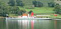
Ullswater from Pooley Bridge, 1989
|
|
| Location | Lake District, England |
| Coordinates | 54°34′39″N 2°52′30″W / 54.5775°N 2.8751°W |
| Type | ribbon lake |
| Basin countries | United Kingdom |
| Max. length | 11.8 km (7.3 mi) |
| Max. width | 1.02 km (0.63 mi) |
| Surface area | 8.9 km2 (3.4 sq mi) |
| Average depth | 25.3 m (83 ft) |
| Max. depth | 63 m (207 ft) |
| Water volume | 223 x 106 m³ |
| Residence time | 350 days |
| Surface elevation | 145 m (476 ft) |
| Settlements | Glenridding, Pooley Bridge |

Ullswater is a beautiful lake in the Lake District in England. It is the second largest lake in this area. The lake is about 14.5 kilometers (9 miles) long. It is also about 1.2 kilometers (0.75 miles) wide. At its deepest point, Ullswater is more than 60 meters (200 feet) deep.
Many people think Ullswater is the most beautiful lake in England. Some even compare it to Lake Lucerne in Switzerland.
Contents
How Ullswater Was Formed
Ullswater is a special type of lake called a "ribbon lake." These lakes are long and narrow. They form after an ice age when huge sheets of ice, called glaciers, move through valleys.
The Power of Glaciers
Imagine a giant scoop digging out the ground. That's what glaciers do! They scoop out the valley floor as they slowly move. When the ice melts and the glaciers retreat, the deep, scooped-out parts fill with water. This is how Ullswater was created. Three separate glaciers worked together to shape the lake.
The Lake's Unique Shape
The mountains around Ullswater give it a unique shape. It looks like a stretched-out letter 'Z'. The lake has three distinct sections, or 'reaches'. These sections wind their way through the surrounding hills.
For much of its length, Ullswater forms a border. It separates the old counties of Cumberland and Westmorland.
Exploring Ullswater's Villages
There are two main villages at opposite ends of Ullswater. Both are popular places for visitors.
Glenridding: A Southern Gem
The village of Glenridding is at the southern end of the lake. It's a favorite spot for many tourists. If you love hiking, this is a great place to start. England's third highest mountain, Helvellyn, is nearby. There are also other challenging peaks to explore. Glenridding has many places to stay. These include two Youth Hostels and camp sites.
Pooley Bridge: Northern Charm
At the northern end of the lake is the village of Pooley Bridge. A narrow bridge from the 16th century crosses the River Eamont here. This river flows out of Ullswater. Near the bridge is Dunmallard Hill. This hill was once home to an Iron Age fort.
Natural Wonders Around the Lake
Ullswater is surrounded by stunning natural beauty.
Aira Force Waterfall
On the western side of the lake, you'll find Aira Force waterfall. It's a beautiful spot where water tumbles down. Near the waterfall, the Brackenrigg Inn offers amazing views. You can see the dramatic landscape stretching out before you.
Images for kids
-
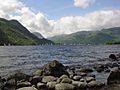
Sailing is a common activity on Ullswater
-
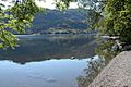
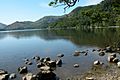
Place Fell viewed across Ullswater
-
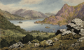
Ullswater painted in 1825
-
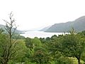
Ullswater from Seldom Seen in Glencoynedale
-
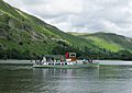
Ullswater steamer SS Lady of the Lake leaves Glenridding
-
View south towards Patterdale
-
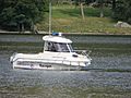
Quicksilver 500 Pilothouse used by the Lake District National Park Authority
-
The Western Belle on Ullswater


