Shap facts for kids
Quick facts for kids Shap |
|
|---|---|
| Village and parish | |
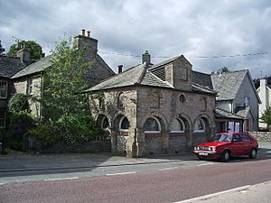
 Shap Market Cross |
|
| Population | 1,264 (2011) |
| OS grid reference | NY563150 |
| Civil parish |
|
| Unitary authority |
|
| Ceremonial county |
|
| Region | |
| Country | England |
| Sovereign state | United Kingdom |
| Post town | PENRITH |
| Postcode district | CA10 |
| Dialling code | 01931 |
| Ambulance | North West |
| EU Parliament | North West England |
| UK Parliament |
|
Shap is a small village in Westmorland and Furness, Cumbria, England. It is surrounded by hills called fells and quiet valleys known as dales. Shap is part of the historic area called Westmorland. In 2011, about 1,264 people lived there.
Contents
Where is Shap Located?
Shap is found along the A6 road and the West Coast Main Line, which is a major railway. It is also close to the M6 motorway. The village is about 10 miles (16 km) from Penrith and about 15 miles (24 km) from Kendal.
Shap is also on the path of the famous Coast to Coast Walk. This long walking route goes from one side of England to the other.
What Does the Name "Shap" Mean?
The name Shap comes from old words like Hēap in Old English or Hjáp in Old Norse. Both mean "heap" or "pile" (of stones). This name probably refers to an ancient stone circle, a cairn (a pile of stones marking a spot), or the Shap Stone Avenue. This stone avenue is a line of old standing stones just west of the village.
A Quick Look at Shap's History
Even though Shap is a small village, it is legally a market town. It received a special permission to hold markets way back in the 1600s. From 1905 to 1935, Shap had its own local government council.
Shap is known for its granite works, which are about a mile outside the village. This granite used to be a separate community with its own shop. The special pink granite from Shap can be seen in many buildings across the UK. You can even find it outside St Paul's Cathedral in London!
Shap Today
Today, Shap has a few places to eat and drink, like three pubs and a fish and chip shop. There's also a small supermarket, a butcher's shop, and a newsagent's. For fun, you can visit an antique book shop, a coffee shop, or a ceramic art studio called Edge Ceramics.
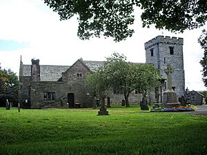
The village has a primary school, a fire station, and an Anglican church. There are also three bed and breakfast places or hostels for visitors. Shap also has a small library, which the community is now helping to run.
Big companies like Hanson and Tata Steel are major employers in the area.
Did you know that some scenes from the movie Withnail and I were filmed around Shap? A place called Sleddale Hall was used as Uncle Monty's cottage in the film.
Sadly, on October 22, 1999, a Hawk jet crashed into an empty barn in the village. It broke apart across the A6 road and the railway line, and both pilots died.
Places to See in Shap
Shap Summit
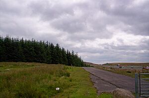
Shap Summit is a high point on both the motorway and the railway line. The area around Shap Fell used to be very difficult for drivers on the A6 road. It's also famous for a steep part of the West Coast Main Line railway. Trains going north have to climb a 1 in 75 slope! In the past, steam trains often needed extra engines from Tebay to help push them up the hill. This area is popular with people who like to photograph trains.
Shap Fell Granite
Shap Fell is known for its special Shap granite. This rock is pink and contains minerals like orthoclase, quartz, and biotite. The Shap Pink Quarry gets its name from this unique pink rock.
Shap Abbey Ruins
Shap Abbey is a beautiful set of ruins located nearby in the quiet valley of the River Lowther. This impressive abbey was built in 1199. It was one of the last abbeys to be closed down by King Henry VIII in 1540.
Shap Wells Spa
Shap Wells has a mineral spa located on the grounds of the Shap Wells hotel. During World War II, this hotel was used as a prisoner of war camp.
Shap in Books
Shap has appeared in a few books!
In Robert Neill's historical novel Crown and Mitre, a scene takes place in Shap. In 1659, the main character, Hal Burnaby, rides through the village on a secret mission to help bring King Charles II back to the throne.
Shap is also mentioned in Anthony Trollope's novel Can You Forgive Her?. It is the closest village to Vavasor Hall, which is the old family home of the main character, Alice Vavasor.
How Shap is Governed
The local area of Shap is called a civil parish. This parish includes the small village of Keld and parts of the granite and limestone works. The parish of Shap works with Shap Rural to share a local council. In 2011, the total population of this area was 1,394 people.
For national government, Shap is part of the parliamentary constituency called Penrith and the Border. A Member of Parliament (MP) represents this area in the UK Parliament.
For local government matters, Shap is now part of Westmorland and Furness.
Travel and Transport
The Lancaster and Carlisle Railway, which is now part of the West Coast Main Line, opened in 1846. It runs along the eastern edge of Shap. The Shap railway station closed in 1968, but some people would like to see it reopen. The closest working railway station is Penrith.
Local Dialect
Most people in Shap speak standard English. However, some people in Shap and the surrounding area speak a special way of talking called the Penrithian dialect. This is a type of the Cumbrian dialect that is spoken around Penrith and the Eden district. These ways of speaking come from older forms of English.
Famous People from Shap
- Sir Charles Richardson (1769-1850), a Royal Navy officer, was born in Shap.
See also
 In Spanish: Shap para niños
 | Sharif Bey |
 | Hale Woodruff |
 | Richmond Barthé |
 | Purvis Young |


