Shap Stone Avenue facts for kids

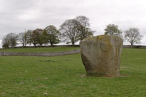
Goggleby Stone
|
|
| Location | Shap, Cumbria |
|---|---|
| Coordinates | 54°30′47″N 2°40′08″W / 54.5131°N 2.6688°W |
| Type | Avenue and stone circle |
| History | |
| Periods | Neolithic |
The Shap Stone Avenue is a collection of ancient stone structures. It is located near Shap in Cumbria, England. This amazing site includes stone circles, long lines of standing stones called an "avenue," and old burial mounds.
Contents
Exploring Shap Stone Avenue
The Shap Stone Avenue is one of three main groups of ancient stone monuments in eastern Cumbria. These sites, which include stone circles, henges, and cairns (piles of stones), are often found along old travel routes.
The Shap monuments stretch along the River Lowther. They follow an important ancient path heading north. Other similar sites, like Long Meg and Her Daughters, are found near the River Eden. Mayburgh Henge is located near the River Eamont.
The exact size and shape of the Shap Stone Avenue are still being studied. Some stones have been lost over time. Also, some natural rocks might have been added to the site later. Early descriptions from people like William Stukeley are hard to match up perfectly.
However, we can see how the avenue fits into the valley. Experts believe there might have been a small lake (a tarn) nearby. The southern end of the stone lines might have finished at a stream. There might also have been a natural spring within the area. These features are also found at the Long Meg and Mayburgh sites.
To the east of the Shap complex, you can find other stone circles and cairns. These include the Hardendale Stone Cairn, Castle Howe, Seal Howe, and Oddendale. The northern part of the avenue seems to point towards a burial mound called Skellaw Hill. The southern part also seems to lead to one or more burial mounds.
The Ancient Avenue
It's hard to know exactly how the original stones of the avenue were arranged without digging them up. Some experts think there were two avenues. One might have been a single, widely spaced row of stones. This row was to the west and northwest of Skellaw Hill.
The other avenue might have had two rows of stones. It could have led from a lost stone circle at Carl Lofts to the southern circle at Kemp Howe. These two avenues form a curve to the west of Shap village. They generally run from the north-northwest to the south-southeast.
The large, pyramid-shaped stones, like the Goggleby Stone and the Thunder Stone, are made of pink granite. This is different from the other boulders at the site. This suggests they were special.
Today, you can still see traces of eight stones that were part of the avenue. These stones led northwest from the Kemp Howe stone circle. Four of these avenue stones are still visible in fields west of Shap. They include the Thunder Stone, the Goggleby Stone, and the Asper's Field Stone.
Let's look at some of the main features you can see from north to south:
The Thunder Stone
The Thunder Stone is a huge stone, one of the first major stones of the avenue. It is located about 3 kilometers northwest of the Kemp Howe stone circle. It sits just northwest of Skellaw Hill.
This stone was not placed into the ground by people. It was left on the surface by melting ice long ago. Because of this, some experts think it might not have been part of the planned avenue.
Skellaw Hill Burial Mound
The avenue passes by the Skellaw Hill barrow. This is also known as the Hill of Skulls. It is a round burial mound. It is located about 2.4 kilometers northwest of the Kemp Howe stone circle.
Asper's Field Stone
The Asper's Field Stone is a very large rock on private land. It is about nine feet (2.7 meters) high and five feet (1.5 meters) wide. It has fallen onto its side. On its top, you can see two "cup markings." One of these has a single ring carved around it.
Goggleby Stone
The Goggleby Stone is the next important stone you'll see. It's just south of Asper's Field. You can find it in a field along a small road between Keld and Shap.
The Goggleby Stone is about ten feet (3 meters) high. It has a cup mark on its north side. Above that, there's a shallow, man-made dip. The Goggleby Stone had fallen over. But it was put back upright by Tom Clare, a county archaeologist, after he dug around it.
Kemp Howe Stone Circle
The remains of the Kemp Howe stone circle are found near the A6 road. They are across from an old petrol station and close to a railway track. This stone circle is quite damaged. Victorian railway builders built their line right through the middle of it.
Only six pink granite stones remain in place. All of these stones have fallen over. They once formed a circle about 14 meters (46 feet) across.
When Was It Built and Why?
Experts believe the Shap Stone Avenue was built during the Late Neolithic period. This was roughly between 3,000 and 2,000 BC. This idea comes from what was found when the Goggleby Stone was excavated.
The Shap complex is special because it doesn't have a large henge or a huge stone circle, like Mayburgh or Long Meg do. However, its layout is similar to these other two sites. Also, the choice of pink granite for the big stones suggests it had a similar important, perhaps religious, purpose. It might have been used for rituals over many generations.
 | Laphonza Butler |
 | Daisy Bates |
 | Elizabeth Piper Ensley |


