
Allerdale facts for kids
Quick facts for kids
Borough of Allerdale
|
||
|---|---|---|
|
Borough
|
||
|
||

Shown within Cumbria
|
||
| Sovereign state | United Kingdom | |
| Constituent country | England | |
| Region | North West England | |
| Ceremonial county | Cumbria | |
| Historic county | Cumberland | |
| Founded | April 1974 | |
| Admin. HQ | Workington | |
| Government | ||
| • Type | Borough Council | |
| Area | ||
| • Total | 480 sq mi (1,242 km2) | |
| Area rank | 17th | |
| Population
(2005 est.)
|
||
| • Total | 97,761 | |
| • Rank | Ranked 247th | |
| • Density | 203.86/sq mi (78.71/km2) | |
| Time zone | UTC+0 (Greenwich Mean Time) | |
| • Summer (DST) | UTC+1 (British Summer Time) | |
| ONS code | 16UB (ONS) E07000026 (GSS) | |
| Ethnicity | 99.4% White British | |
| Website | allerdale.gov.uk | |

Allerdale is a special area in Cumbria, England. It has a special local government called a "borough." The main office for its council is in Workington. In 2011, about 96,422 people lived there.
The Borough of Allerdale was created on April 1, 1974. This happened by combining several smaller towns and areas. These included Workington, Maryport, Cockermouth, and Keswick. It also included rural areas like Cockermouth and Wigton. All these places were part of the old county of Cumberland. In 1995, Allerdale officially became a "borough."
The name "Allerdale" comes from an old region. This region was divided into two parts: Allerdale-above-Derwent and Allerdale-below-Derwent. The current borough mostly covers the area of Allerdale-below-Derwent. Long ago, much of this area was a royal forest. This meant it was a special hunting ground for the king and had its own laws.
Contents
Towns and Villages in Allerdale
Workington is the biggest town in the borough. It is also where the main council office, Allerdale House, is located. People sometimes call this building "Perry's Palace."
Other towns and villages in Allerdale include:
- Abbeytown
- Allonby
- Aspatria
- Bolton Low Houses
- Bothel
- Brigham
- Broughton
- Great Clifton
- Cockermouth
- Crosby
- Dean
- Dearham
- Fletchertown
- Flimby
- Ireby
- Keswick
- Kirkbride
- Maryport
- Mawbray
- Plumbland
- Seaton
- Silloth
- Tallentire
- Thursby
- Waverton
- Westnewton
- Wigton
Freedom of the Borough
The "Freedom of the Borough" is a special honor given to people or groups. It's a way for the council to show great respect and thanks.
Honored Individuals
- Malcolm Wilson (OBE): He received this honor on March 28, 2018.
- Ben Stokes: He was honored on September 25, 2019.
- Rt Hon Lord Campbell-Savours of Allerdale.
How Allerdale is Governed
Elections for the borough council happen every four years. Forty-nine councillors are chosen from 23 different areas called wards. Since 2003, no single political party has had full control of the council.
After the 2019 election, the council is run by a mix of the Conservative Party and independent councillors. The current leader is Councillor Marion Fitzgerald, who is an Independent. The deputy leader is Mike Johnson from the Conservative Party.
| Date | Labour | +/- | Conservative | +/- | Independent | +/- | Liberal Democrat | +/- | UKIP | +/- | Control | |||||
| 2011 | 28 | 12 | 15 | 1 | 0 | NOC | ||||||||||
| 2013 | 27 | -1 | 12 | = | 16 | +1 | 0 | -1 | 1 | +1 | NOC | |||||
| 2014 | 27 | = | 12 | = | 13 | -3 | - | 4 | +3 | NOC | ||||||
| 2015 | 28 | +1 | 17 | +5 | 8 | -5 | - | 3 | -1 | NOC | ||||||
| Dec 2016 | 28 | = | 16 | -1 | 10 | +2 | - | 2 | -1 | NOC | ||||||
| 2019 | 14 | -14 | 15 | -1 | 20 | +10 | 0 | = | 0 | -2 | NOC | |||||
Derwent 7 Parishes Group
The Derwent 7 Community Led Planning Group was started in 2007. It includes the town and parish councils of seven areas. These areas are Above Derwent, Bassenthwaite, Borrowdale, Keswick, St John's, Castlerigg and Wythburn, Threlkeld, and Underskiddaw.
This group received money from Allerdale Borough Council. It works on local planning and has different smaller groups. One of these groups focuses on transport. The Keswick Museum also collects items from these "Derwent Seven Parishes."
Map of Allerdale
Images for kids
-
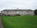
Allerdale House, the council's headquarters.

See also
 In Spanish: Allerdale para niños
