
Cockermouth facts for kids
Quick facts for kids Cockermouth |
|
|---|---|
| Town and parish | |
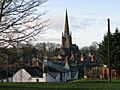
 All Saints Church |
|

Cockermouth
|
|
| Population | 8,761 (2011 census) |
| OS grid reference | NY121304 |
| • London | 526 km |
| Civil parish |
|
| Unitary authority |
|
| Ceremonial county | |
| Region | |
| Country | England |
| Sovereign state | United Kingdom |
| Post town | COCKERMOUTH |
| Postcode district | CA13 |
| Dialling code | 01900 |
| Police | Cumbria |
| Fire | Cumbria |
| Ambulance | North West |
| EU Parliament | North West England |
| UK Parliament |
|
Cockermouth is a lively market town in Cumbria, England. Its name comes from its location: where the River Cocker flows into the River Derwent. In 2011, about 8,761 people lived here.
This historic town is just outside the Lake District National Park. Many of its old buildings and streets still look much like they did hundreds of years ago. Cockermouth has a long history, going back 800 years. The town has faced challenges like flooding, especially in 2005, 2009, and 2015.
Mary, Queen of Scots visited Cockermouth in 1568. This was after she lost the Battle of Langside. She is said to have stayed with Henry Fletcher.
Contents
What Does Cockermouth Mean?
The name Cockermouth simply means "the mouth of the River Cocker." The river's name, Cocker, comes from an old Celtic word, kukrā. This word means 'the crooked one'. It's often listed as one of England's more unusual place names.
Where is Cockermouth Located?
Cockermouth exists because two rivers, the Cocker and the Derwent, meet here. This spot was historically the easiest place to build a bridge over the fast-flowing river. The town is also very close to beautiful lakes. These include Buttermere, Crummock Water, Loweswater, and Bassenthwaite.
What is Cockermouth's Climate Like?
Cockermouth has a mild climate. It is affected by the Irish Sea and its low elevation. The town gets a bit less rain than the UK average. Temperatures are also similar to the rest of the UK. The closest weather station is in Aspatria, about 7 miles (11 km) north of the town.
The hottest temperature recorded nearby was 31.3°C (88.3°F) in Lorton in 2006. The coldest was -13.9°C (7.0°F) in Aspatria in 1982. West Cumbria gets less snow than the Lake District. This is because it is near the Irish Sea and not very high up.
| Climate data for Aspatria, elevation: 62 m (203 ft), 1981–2010 normals | |||||||||||||
|---|---|---|---|---|---|---|---|---|---|---|---|---|---|
| Month | Jan | Feb | Mar | Apr | May | Jun | Jul | Aug | Sep | Oct | Nov | Dec | Year |
| Mean daily maximum °C (°F) | 6.8 (44.2) |
7.1 (44.8) |
9.2 (48.6) |
11.9 (53.4) |
15.3 (59.5) |
17.5 (63.5) |
19.3 (66.7) |
18.9 (66.0) |
16.6 (61.9) |
13.1 (55.6) |
9.5 (49.1) |
6.9 (44.4) |
12.7 (54.9) |
| Daily mean °C (°F) | 4.2 (39.6) |
4.2 (39.6) |
6.0 (42.8) |
8.0 (46.4) |
10.9 (51.6) |
13.5 (56.3) |
15.5 (59.9) |
15.2 (59.4) |
13.0 (55.4) |
9.9 (49.8) |
6.7 (44.1) |
4.1 (39.4) |
9.2 (48.6) |
| Mean daily minimum °C (°F) | 1.5 (34.7) |
1.3 (34.3) |
2.7 (36.9) |
4.0 (39.2) |
6.5 (43.7) |
9.5 (49.1) |
11.6 (52.9) |
11.4 (52.5) |
9.4 (48.9) |
6.7 (44.1) |
3.9 (39.0) |
1.3 (34.3) |
5.8 (42.4) |
| Average precipitation mm (inches) | 101.1 (3.98) |
74.8 (2.94) |
78.6 (3.09) |
57.0 (2.24) |
58.6 (2.31) |
69.9 (2.75) |
73.7 (2.90) |
89.3 (3.52) |
89.8 (3.54) |
121.4 (4.78) |
104.7 (4.12) |
106.6 (4.20) |
1,025.6 (40.38) |
| Average precipitation days (≥ 1.0 mm) | 15.3 | 10.4 | 13.5 | 11.4 | 10.5 | 10.9 | 12.0 | 12.9 | 12.0 | 16.1 | 14.4 | 14.6 | 153.9 |
| Mean monthly sunshine hours | 47.5 | 77.0 | 114.0 | 159.8 | 217.1 | 195.2 | 191.6 | 179.8 | 136.1 | 98.7 | 61.2 | 41.6 | 1,519.6 |
| Source: Met Office | |||||||||||||
How is Cockermouth Governed?
Since 2024, Cockermouth is part of the Penrith & Solway area. This area elects a Member of Parliament (MP) to the UK Parliament. An MP is a person chosen by local voters to represent them. The current MP for this area is Markus Campbell-Savours from the Labour Party.
For local matters, Cockermouth is part of the Cumberland (unitary authority) area. This change happened in April 2023.
Cockermouth's History
The Romans built a fort near Cockermouth. It was called Derventio Carvetiorum. This fort protected a river crossing on an important route. This route was used by troops heading to Hadrian's Wall.
The town we know today grew under the Normans. They built Cockermouth Castle closer to the river. Not much of the castle remains now. The town developed its unique medieval layout. It had a wide main street with houses. Each house had a long plot of land stretching to a "back lane." This layout is still largely visible today.
Cockermouth was an important town in Cumberland. It shared legal hearings with Carlisle. Before 1832, it was often where MPs for Cumberland were elected.
Cockermouth as a Market Centre
Cockermouth has had a market since before 1221. King Henry III officially granted market charters in 1221 and 1227. In the past, pubs in Cockermouth could stay open all day on market days. This made the town a popular place for people to visit. Today, the farmers' market happens only at certain times of the year. It has been replaced by weekend craft and international markets.
Flooding in Cockermouth
Cockermouth has suffered from severe floods. One major flood happened on November 19-20, 2009. Over 200 people had to be rescued. Helicopters and boats helped to save them. Water levels in the town centre reached as high as 2.5 meters (8 feet). Many historic buildings were badly damaged. Bridges in and around the town also suffered. Recovery was slow, but most damage was repaired by 2011.
Another big flood happened in 2015. The River Derwent burst its banks on December 5. Hundreds of homes and businesses were affected. In October 2023, part of the Old Courthouse fell into the River Cocker.
Cockermouth's Architecture

Much of Cockermouth's town centre is very old. It has a medieval design, but many buildings were rebuilt in the Georgian style. Later, Victorian buildings were added. Kirkgate street has beautiful 17th and 18th-century houses. They have cobbled paths and curving lanes. Most buildings are made of traditional stone and slate. They have thick walls and green Skiddaw slate roofs.
Many buildings look like simple fronts on the street. But behind them are historic houses in narrow alleyways. These alleys often follow medieval street patterns. You can find Georgian homes near the Market Place and Kirkgate.
Cockermouth might have been one of the first towns in Britain to test electric lighting. In 1881, six electric lamps were set up. However, the electricity was not reliable. So, the town went back to gas lighting. In 1964, Cockermouth was named one of 51 'Gem Towns' in the UK. This showed how important its historic buildings are.
Cockermouth Today

Cockermouth's town centre still has its historic feel. The Market Place has been updated. It is now a cultural and community hub. The Kirkgate Centre is a main cultural spot. It shows historical displays and hosts theatre, music, and films. The main street has a statue of Lord Mayo. He was once an MP for Cockermouth. He later became the British Viceroy of India.
The Market Place has been "regenerated" with funding from the European Union. It is now friendly for walkers. It has stone paving and seating. Pavement art and stonework remember local history. They show things like John Dalton's atomic theory and local dialect.
A cycleway runs along the old Cockermouth, Keswick and Penrith Railway route. It crosses a high bridge over the Cocker River. This bridge offers great views of the town.

Important Landmarks
.jpg)


Cockermouth Castle is a large, partly ruined Norman castle. It was built where the Cocker and Derwent rivers meet. The castle has a leaning tower. It is usually only open to the public once a year.
Wordsworth House is the birthplace of famous poets William Wordsworth and Dorothy Wordsworth. It has been repaired after the 2009 floods. It shows an 18th-century kitchen and children's bedroom. Harris Park offers walks along the river.
Jennings Brewery used to offer public tours. However, the brewery closed in October 2022. The buildings are now for sale.
Cockermouth Town Hall used to be a chapel. It was changed into a town hall in 1934.
The Kirkgate Centre offers international music, theatre, and films. Cockermouth also has an annual festival in the summer. The town hosts an Easter Fair, fireworks, and a carnival. At Christmas, the town is decorated with festive lights.
The main cemetery on Lorton Road is a nice place for a walk. It has streams and stone bridges. The nearby village of Papcastle is also pretty. It stands on the site of the Roman fort of Derventio (Papcastle).
About 2.5 miles (4 km) northwest of town is Dovenby Hall Estate. This 115-acre (47 ha) park is home to the Ford Rally team. It is where M-Sport prepares cars for the World Rally Championship.
Economy and Services
Cockermouth started as a market town. It was near a fast-flowing river in a farming area. It became a centre for spinning and weaving cloth. By the mid-1800s, there were over forty factories. These included mills for wool, linen, and cotton. There were also hat factories and tanneries.
Later, industries needed steam power. So, many factories closed. But the arrival of the railway and tourism helped the town. William Wordsworth's writings also made Cockermouth popular. Today, the local economy still relies on farming and tourism. There are also light industries that serve local needs.
Education
Cockermouth has two primary schools:
- Fairfield Primary School
- All Saints Church of England Primary School
Cockermouth School is a comprehensive secondary school. It has about 1400 students, including those in the sixth form. In 2009, Cockermouth School won a regional kids' literature quiz.
In 2023, Whitehaven's Mayfield School opened a campus in Cockermouth. This campus is for children with special educational needs. It is located where St Joseph's Primary School used to be.
Transport in Cockermouth
Road Travel
The closest major highway is the M6 at Penrith. This is about 30 miles (48 km) away via the A66.
Train Travel
The Cockermouth, Keswick and Penrith Railway used to serve the town. The Cockermouth railway station opened in 1865. It was mentioned in the 1964 song "Slow Train". The station closed in 1966. The site is now used by the town's fire station. The old railway line is now a public walkway. The nearest train stations are Maryport and Penrith.
Bus Travel
The main bus services are the Stagecoach Cumbria routes X4 and X5. These buses connect Cockermouth with Workington, Keswick, and Penrith. They run every half hour. There are also local town bus services (C1/C2/C3). Another bus route, the 600, goes to Wigton and Carlisle.
Air Travel
The closest major airport is Newcastle Airport. Leeds Bradford International Airport is a bit further. Manchester Airport offers even more flight choices.
Two cycle routes pass through Cockermouth. These are the Sea to Sea Cycle Route and the Reivers Cycle Route.
Sports and Leisure
Cockermouth has a sports centre with a swimming pool. It also has two gyms. There are two parks with paths along the river.
Cockermouth Cricket Club is one of the town's most successful sports teams. They play their games at the Sandair Ground. The club has teams for different age groups.
Cockermouth School has an Astroturf pitch. It is used for community football, including a local 6-a-side league.
Cockermouth Rugby Football Club is located at the old Cockermouth Grammar School site. In 1987, they played one of the first rugby union league matches.
The town has a youth football club, Cockermouth F.C. In the 2007–2008 season, their Under 12 team won the County Cup.
Famous People from Cockermouth


- Richard Bourke (Lord Mayo) – An MP for Cockermouth and later Viceroy of India.
- Fletcher Christian – Leader of the famous mutiny on the Bounty.
- John Dalton – A famous chemist and physicist. He developed the atomic theory in chemistry.
- Fearon Fallows – An English astronomer.
- Luke Greenbank – A swimmer.
- Ben Stokes – A well-known cricketer.
- Dorothy Wordsworth – A poetess and sister of William Wordsworth.
- William Wordsworth – A very famous poet.
Twin Town
Cockermouth is twinned with Marvejols, France.
Images for kids
-
All Saints Church
See also
 In Spanish: Cockermouth para niños
