Maryport facts for kids
Quick facts for kids Maryport |
|
|---|---|
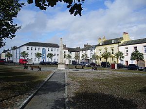
 Fleming Square, Maryport |
|
| Population | 11,262 (2011) |
| OS grid reference | NY038363 |
| Civil parish |
|
| Unitary authority |
|
| Ceremonial county | |
| Region | |
| Country | England |
| Sovereign state | United Kingdom |
| Post town | MARYPORT |
| Postcode district | CA15 |
| Dialling code | 01900 |
| Police | Cumbria |
| Fire | Cumbria |
| Ambulance | North West |
| EU Parliament | North West England |
| UK Parliament |
|
Maryport is a town and civil parish located in the Cumberland area of England. In 2011, about 11,262 people lived in the parish.
The town is just outside the beautiful Lake District National Park. It sits at the northern end of what used to be the Cumberland Coalfield, an important area for coal mining.
Contents
Where is Maryport Located?
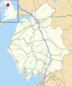
Maryport is on the A596 road, about 6 kilometers (4 miles) north of Workington. It's also about 21 kilometers (13 miles) west of Keswick and 26 kilometers (16 miles) south-west of Carlisle. If you travel north on the B5300 coast road, you'll reach Silloth, which is about 20 kilometers (12.6 miles) away. Along this road, you'll pass through small villages like Allonby and Mawbray.
Maryport is one of the southernmost towns on the Solway Firth. The River Ellen flows past Netherhall School before entering the Solway Firth through Maryport. You can also reach Maryport by train, as Maryport railway station is on the Cumbrian Coast Line.
What is Maryport's History?
Early Times: Prehistoric and Roman History
Scientists have found signs of people living in Maryport during the Stone Age. This shows that people were here a very long time ago.
The town was first built around the year 122 by the Romans. They called it Alauna. It was an important base for supplies and soldiers. This fort helped protect the western end of Hadrian's Wall. The Romans built a series of forts along the coast to stop enemies from going around the wall by crossing the Solway Firth.
Today, you can still see many parts of the Roman fort. Surveys have shown that a large Roman town grew up around the fort. There was also a local British settlement nearby. These local people might have supplied the fort with food in exchange for things like pottery.
The Senhouse Roman Museum is next to the old fort. It has a copy of a wooden watch-tower that looks out over the fort and the sea. Inside the museum, you can see many Roman altar stones that were found at the site.
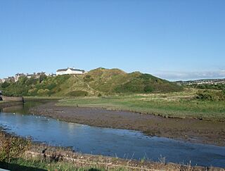
On Castle Hill, you can find the remains of a castle built in the 1100s. It was a motte-and-bailey castle, which means it had a mound (motte) and a walled area (bailey). On top of the hill, there are also foundations from a World War II gun position.
North of the town are the ruins of the Netherhall Estate. All that's left of this once-large house are the stables and a 14th-century pele tower. This tower was built using Roman stones, probably from the nearby Alauna fort. The main house was taken down in 1979 after a fire.
Georgian and Victorian Eras: Growth as a Port
For many years, the town was called Ellenfoot. But its name was changed by Humphrey Senhouse. He started to develop the town as a port, just like Whitehaven. In 1749, a special law was passed to create the town we know today. Humphrey Senhouse named the new town Maryport after his wife, Mary.
The Senhouse family owned land in the area. They were key in developing the town and digging up its Roman past. They also had business interests in the West Indies, where some family members owned sugar and coffee plantations.
During this time, the town's lighthouse was built.
Maryport quickly grew into an industrial center in the 1800s. An iron foundry opened, and the port became very busy. Shipyards, like Wood's and Ritson's, also started up. Ritson's yard was famous because it had to launch ships sideways into the River Ellen. The river wasn't wide enough to launch them the usual way!
The Maryport and Carlisle Railway opened in the 1840s. George Stephenson, a famous engineer, helped build it. This railway made it much easier to transport coal. Many new coal mines opened in the Aspatria area, and almost all their coal went through Maryport's port. In 1846, over 213,000 tons of coal were shipped from Maryport. By 1857, this number grew to more than 340,000 tons. Much of the coal was turned into coke, which was used in the local iron and steel industry.
In 1874, coal mine owners cut miners' wages. This led to a strike that spread across the area, involving 2,000 men. The strike lasted for months. Some miners left the area to find work elsewhere. Later, in 1894, some local miners tried to run their own mines as co-operatives. But they found it hard to compete with bigger companies, and this experiment ended in 1903.
Modern Times: Changes and New Beginnings
In the early 1900s, trade in the docks stayed steady. However, it was badly affected by the General Strike of 1926. Then, in 1927, a new, deeper dock opened in Workington. This meant that a lot of the trade that used to come through Maryport moved to Workington. The local Solway Blast Furnaces also closed down.
Maryport faced tough times. By 1933, more than half of the town's workers were unemployed. Many people relied on public funds to live. In 1936, twenty unemployed men from Maryport joined the Jarrow Crusade. They marched to London to protest unemployment.
There was a small boom during Second World War when coal was sent to the port. But Maryport never fully recovered its old industries. The docks closed to cargo ships in the 1960s. The last deep coal mine in the area closed in 1966.
Today, Maryport is looking to the future. It has had many big projects to improve the town, like building a yacht marina in the harbour. Tourism is now becoming a very important part of the town's economy.
Maryport Lighthouse
Maryport has a small lighthouse. It used to be managed by Trinity House, which is in charge of lighthouses in England. The lighthouse is a Grade II listed building, which means it's an important historical structure.
In 2010, the Maryport Harbour Authority took over responsibility for the light. In 2017, the old lighthouse was fixed up and repainted. This was part of a government plan to help improve seaside towns.
How is Maryport Governed?
Maryport is part of the parliamentary area called Penrith and Solway. Since the 2024 general election, Markus Campbell-Savours from the Labour Party has been the Member of Parliament (MP) for this area. Before that, Mark Jenkinson from the Conservative Party was the MP. Historically, Maryport has usually supported the Labour Party.
For local government, Maryport is part of the Cumberland unitary authority area. From 1974 to 2023, it was part of the Allerdale district.
Maryport also has its own local government body, called Maryport Town Council. This council helps make decisions for the town.
What is Maryport's Economy Like Today?
Maryport's economy used to be all about mining and sea trade. But these industries have mostly gone away. Now, the town relies on tourism to help its economy.
You can visit a few interesting places in Maryport:
- An aquarium, where you can see sea creatures.
- The Maryport Maritime Museum, which is in an old pub by the harbor. It opened in 1975 and tells the story of Maryport's sea history.
- A Roman museum, which has many Roman artifacts. These include altars dedicated to Jupiter, found near the Roman fort.
In 2008, a new place called the Wave Centre opened. It's a theater and conference center. It also has an interactive exhibition about Maryport's local history, a Tourist Information Centre, a gift shop, and a bistro.
Maryport has two industrial areas, Glasson Industrial Estate and Solway Industrial Estate. Many small local businesses are located here. The town used to have a factory for the Bata shoe company, but it closed in the early 1980s.
What is Maryport's Culture Like?
Maryport is well-known in the blues music world. Every summer, it hosts the "Maryport Blues Festival." Famous musicians like Jools Holland, Dionne Warwick, and Van Morrison have played there. This three-day event usually happens on the last weekend of July and brings together artists from all over the world. However, the 2018 festival was canceled.
Maryport also has an annual "Taste of The Sea" food festival. Visitors can try delicious food from all over Cumbria, like Rum Butter and Kendal Mint Cake.
The town has a Scout Group called 2nd Maryport, which has been active for over 70 years. It includes different sections of the Scouting Movement. There is also a Girl Guiding Group, a Young Archaeology Society, and a local wildlife conservation society.
If you like golf, Maryport Golf Club has an 18-hole course that opened in 1905.
Media and News in Maryport
Local news and TV shows for Maryport come from BBC North East and Cumbria and ITV Border. TV signals are received from the Caldbeck TV transmitter.
You can listen to local radio stations like BBC Radio Cumbria on 95.6 FM and Greatest Hits Radio Cumbria & South West Scotland on 102.2 FM.
The town's local newspaper is the Times & Star.
Education in Maryport
Maryport has five primary schools for younger students. For older students, there is one secondary school, Netherhall School.
Famous People from Maryport
Many notable people have come from Maryport, including:
- Dan Bewley, a speedway rider
- Fletcher Christian, a famous mutineer from the ship HMS Bounty
- Douglas Clark, a rugby league player
- William Harrison, the first captain of Brunel's huge ship, the SS Great Eastern
- Thomas Henry Ismay, who started the famous White Star Line shipping company
- Ricky Lightfoot, a world champion trail runner
- Edward Benn Smith, who received the Victoria Cross for bravery
See also
 In Spanish: Maryport para niños
 | Stephanie Wilson |
 | Charles Bolden |
 | Ronald McNair |
 | Frederick D. Gregory |


