Clay County, Tennessee facts for kids
Quick facts for kids
Clay County
|
|
|---|---|

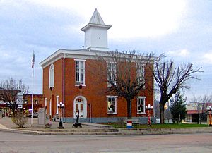
Clay County Courthouse in Celina
|
|

Location within the U.S. state of Tennessee
|
|
 Tennessee's location within the U.S. |
|
| Country | |
| State | |
| Founded | 1870 |
| Named for | Henry Clay |
| Seat | Celina |
| Largest city | Celina |
| Area | |
| • Total | 259 sq mi (670 km2) |
| • Land | 237 sq mi (610 km2) |
| • Water | 23 sq mi (60 km2) 8.8%% |
| Population
(2020)
|
|
| • Total | 7,581 |
| • Density | 33/sq mi (13/km2) |
| Time zone | UTC−6 (Central) |
| • Summer (DST) | UTC−5 (CDT) |
| Congressional district | 6th |
Clay County is a special area in the U.S. state of Tennessee. It's called a county. In 2020, about 7,581 people lived here. The main town and only city in Clay County is Celina. Clay County got its name from Henry Clay. He was a famous American leader from Kentucky who served in the United States Senate and as United States Secretary of State a long time ago.
Contents
History of Clay County
Clay County was created in 1870. It was made from parts of two nearby counties: Jackson and Overton. A very important person named Cordell Hull had his first law office in Clay County. This office is now a museum you can visit.
Early Life and Work
In the past, people in Clay County mostly farmed. They also worked along the Cumberland River. The river was the main way to travel and move goods around. There were many docks and ferry crossings. These helped transport crops and animals to bigger markets. The timber industry, which means cutting down trees for wood, was also a big job for many years. It still provides jobs today.
Tobacco farming became important in the 1900s. You can still see many old tobacco barns around. Today, tobacco farming is not as common. Now, cattle, chickens, and corn are the main farm products. Clay County is one of the top places in Tennessee for raising chickens.
The Civil War Years
During the Civil War, many small battles happened along the Cumberland River. Both sides wanted to control the river to move supplies. People in local towns had different ideas about who to support. This caused disagreements between families. Some of these old disagreements can still be felt today.
Celina and Its Rivers
The town of Celina is where the Obey and Cumberland rivers meet. This made it a very busy port when steamboats were common. Steamboats traveled between Nashville and Burnside, Kentucky. Even though the old ferry landing is gone, Celina still connects places by road.
Another important spot was Butler's Landing. It had big storage buildings owned by the Butler family. The first meeting for Clay County's government happened near the river at Butler's Landing in 1871. Butler's Landing almost became the county seat, but Celina won by a small number of votes.
Looking to the Future
Because Clay County is mostly rural, it has been harder to bring in new businesses. This has sometimes led to higher unemployment rates compared to other parts of Tennessee. When there aren't enough jobs, young people sometimes leave to find more opportunities.
To help with this, a main road called SR 52 has been made bigger. It is now a four-lane highway. This road connects to I-40 in Cookeville. There are also plans to build a new industrial park in Celina. People hope this will bring more jobs to the county.
Geography of Clay County
Clay County covers about 259 square miles. Most of this is land (237 square miles), and a smaller part is water (23 square miles). The Cumberland River flows right through the middle of the county. The Obey River also flows through Celina. It comes from Dale Hollow Lake, which covers a lot of the eastern part of the county.
Neighboring Counties
- Monroe County, Kentucky (north)
- Cumberland County, Kentucky (northeast)
- Clinton County, Kentucky (northeast)
- Pickett County (east)
- Overton County (southeast)
- Jackson County (south)
- Macon County (west)
Protected Natural Areas
- Standing Stone State Forest (part of it is in Clay County)
Main Roads
 SR 51
SR 51 SR 52
SR 52 SR 53
SR 53 SR 135
 SR 292
 SR 294
People of Clay County (Demographics)
| Historical population | |||
|---|---|---|---|
| Census | Pop. | %± | |
| 1880 | 6,987 | — | |
| 1890 | 7,260 | 3.9% | |
| 1900 | 8,421 | 16.0% | |
| 1910 | 9,009 | 7.0% | |
| 1920 | 9,193 | 2.0% | |
| 1930 | 9,577 | 4.2% | |
| 1940 | 10,904 | 13.9% | |
| 1950 | 8,701 | −20.2% | |
| 1960 | 7,289 | −16.2% | |
| 1970 | 6,624 | −9.1% | |
| 1980 | 7,676 | 15.9% | |
| 1990 | 7,238 | −5.7% | |
| 2000 | 7,976 | 10.2% | |
| 2010 | 7,861 | −1.4% | |
| 2020 | 7,581 | −3.6% | |
| U.S. Decennial Census 1790-1960 1900-1990 1990-2000 2010-2020 2020 |
|||
Every ten years, the United States counts its population. This is called a census. The table above shows how the number of people living in Clay County has changed over many years.
What the 2020 Census Shows
| Group | Number of People | Percentage |
|---|---|---|
| White (not Hispanic) | 7,202 | 95.0% |
| Black or African American (not Hispanic) | 76 | 1.0% |
| Native American | 17 | 0.22% |
| Asian | 5 | 0.07% |
| Pacific Islander | 1 | 0.01% |
| Other/Mixed | 150 | 1.98% |
| Hispanic or Latino | 130 | 1.71% |
In 2020, the census counted 7,581 people living in Clay County. These people lived in 3,039 households, and 2,002 of these were families. The table above shows the different groups of people living in the county.
Towns and Communities

City
- Celina (This is the county seat, meaning it's where the county government is located.)
Small Communities
- Bakerton
- Baptist Ridge
- Free Hill
- Hermitage Springs
- Midway
- Moss
- Pea Ridge
Old Town (Ghost Town)
- Willow Grove
See also
 In Spanish: Condado de Clay (Tennessee) para niños
 | Percy Lavon Julian |
 | Katherine Johnson |
 | George Washington Carver |
 | Annie Easley |


