
Jackson County, Tennessee facts for kids
Quick facts for kids
Jackson County
|
|
|---|---|

Jackson County Courthouse in Gainesboro
|
|

Location within the U.S. state of Tennessee
|
|
 Tennessee's location within the U.S. |
|
| Country | |
| State | |
| Founded | 1801 |
| Named for | Andrew Jackson |
| Seat | Gainesboro |
| Largest town | Gainesboro |
| Area | |
| • Total | 320 sq mi (800 km2) |
| • Land | 308 sq mi (800 km2) |
| • Water | 11 sq mi (30 km2) 3.5%% |
| Population
(2020)
|
|
| • Total | 11,617 |
| • Density | 38/sq mi (15/km2) |
| Time zone | UTC−6 (Central) |
| • Summer (DST) | UTC−5 (CDT) |
| Congressional district | 6th |
Jackson County is a place in the state of Tennessee, USA. It is called a county. In 2020, about 11,617 people lived there. The main town and government center of the county is Gainesboro. Jackson County is also part of the larger Cookeville area.
Contents
History of Jackson County
Jackson County was officially created on November 6, 1801. This was done by a group of lawmakers called the Tennessee General Assembly. It was the 18th county to be formed in Tennessee. The county was made from parts of Smith County and some land that belonged to Native American tribes.
The county was named after Andrew Jackson. By 1801, he was already famous in Tennessee. He had been a member of the U.S. Congress and a Senator. He also served as a judge for the Tennessee Supreme Court and was a colonel in the Tennessee militia, which was like a local army. Later, he became even more famous as a general in the Battle of New Orleans. He then became the seventh President of the United States.
In the 1790s, an army base called Fort Blount was built. It was about 10 miles (16 km) west of Gainesboro, along the Cumberland River. This fort was an important stop for people traveling on a path called Avery's Trace. A town named Williamsburg grew around the fort. This town was the main government center for Jackson County from 1807 to 1819. Sadly, all the early records of the county were lost in a big fire at the courthouse on August 14, 1872.
In 1970, a movie called "I Walk The Line" was filmed in Gainesboro and Jackson County. It starred the actor Gregory Peck.
Geography of Jackson County

Jackson County covers a total area of about 320 square miles (829 square kilometers). Most of this area, about 308 square miles (798 square kilometers), is land. The rest, about 11 square miles (28 square kilometers), is water.
Neighboring Counties
Jackson County shares its borders with these other counties:
- Clay County (to the north)
- Overton County (to the east)
- Putnam County (to the south)
- Smith County (to the southwest)
- Macon County (to the northwest)
Protected Natural Areas
Several areas in Jackson County are protected by the state to preserve nature:
- The Boils Wildlife Management Area
- Cummins Falls State Park
- Cordell Hull Wildlife Management Area (part of it)
- Washmorgan Hollow State Natural Area
Main Roads
These are some of the state highways that go through Jackson County:
 SR 53
SR 53 SR 56
SR 56 SR 85
SR 85 SR 96
SR 96 SR 151
 SR 135
 SR 262
 SR 290
People of Jackson County
As of the 2020 United States census, there were 11,617 people living in Jackson County. There were 4,566 households, which are groups of people living together in homes. Also, there were 2,745 families living in the county.
Towns and Communities
Main Town
- Gainesboro (This is the county seat, where the main government offices are.)
Smaller Communities
- Dodson Branch (This is a census-designated place, meaning it's a community identified by the census bureau.)
Other Communities
Images for kids
-
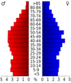
This chart shows the age groups of people living in Jackson County.

See also
 In Spanish: Condado de Jackson (Tennessee) para niños
