
Pickett County, Tennessee facts for kids
Quick facts for kids
Pickett County
|
|
|---|---|

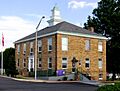
Pickett County Courthouse in Byrdstown
|
|

Location within the U.S. state of Tennessee
|
|
 Tennessee's location within the U.S. |
|
| Country | |
| State | |
| Founded | 1879 |
| Named for | Howard L. Pickett, state legislator |
| Seat | Byrdstown |
| Largest town | Byrdstown |
| Area | |
| • Total | 174 sq mi (450 km2) |
| • Land | 163 sq mi (420 km2) |
| • Water | 12 sq mi (30 km2) 6.6%% |
| Population
(2020)
|
|
| • Total | 5,001 |
| • Density | 31/sq mi (12/km2) |
| Time zone | UTC−6 (Central) |
| • Summer (DST) | UTC−5 (CDT) |
| Congressional district | 6th |
Pickett County is a county located in the state of Tennessee. In 2020, about 5,000 people lived there. This makes it the county with the fewest people in Tennessee. Its main town, called the county seat, is Byrdstown.
Byrdstown and the town of Albany in Kentucky are located between two large lakes. These lakes are Dale Hollow Lake (mostly in Tennessee) and Lake Cumberland (in Kentucky). This area is often called "Twin Lakes." Byrdstown is known as "The Gateway To Dale Hollow Lake" because it's a main entrance to the lake. Many people visit the resorts around these lakes every year for vacations.
Contents
History of Pickett County
Pickett County was created in 1879. It was formed from parts of Overton and Fentress counties. The county was named after Howell Lester Pickett. He was a member of the state legislature, which is a group of people who make laws. Howell Pickett helped a lot in creating the county.
A very famous person, Cordell Hull, was born in this area. He won the Nobel Peace Prize. Cordell Hull was honored for helping to create the United Nations. This organization works for peace and cooperation around the world.
Geography and Nature
Pickett County covers about 174 square miles. Most of this area, about 163 square miles, is land. The rest, about 12 square miles, is water. It is one of the smallest counties in Tennessee.
The eastern part of the county is on the Cumberland Plateau. This area has many hills and forests, including part of Pickett State Forest. The western part of the county has more people. It is located on the Highland Rim.
Two important rivers, the Wolf River and the Obey River, flow through the county. The lower parts of these rivers are now part of Dale Hollow Lake. The rivers meet near the border with Clay County. Some streams in the far eastern part of the county flow into the Big South Fork of the Cumberland River.

Neighboring Counties
Pickett County shares its borders with several other counties:
- Wayne County, Kentucky (to the northeast)
- Scott County (to the east)
- Fentress County (to the southeast)
- Overton County (to the southwest)
- Clay County (to the west)
- Clinton County, Kentucky (to the north)
Parks and Protected Areas
Pickett County is home to several beautiful natural areas:
- Big South Fork National River and Recreation Area (a very small part)
- Cordell Hull Birthplace State Park
- Honey Creek State Natural Area
- Pickett State Forest (part of it)
- Pickett CCC Memorial State Park
- Twin Arches State Natural Area (part of it)
Main Roads
These are some of the main roads that go through Pickett County:
 US 127
 SR 111
 SR 154
 SR 295
 SR 325
Population Facts
| Historical population | |||
|---|---|---|---|
| Census | Pop. | %± | |
| 1890 | 4,736 | — | |
| 1900 | 5,366 | 13.3% | |
| 1910 | 5,087 | −5.2% | |
| 1920 | 5,205 | 2.3% | |
| 1930 | 5,615 | 7.9% | |
| 1940 | 6,213 | 10.7% | |
| 1950 | 5,093 | −18.0% | |
| 1960 | 4,431 | −13.0% | |
| 1970 | 3,774 | −14.8% | |
| 1980 | 4,358 | 15.5% | |
| 1990 | 4,548 | 4.4% | |
| 2000 | 4,945 | 8.7% | |
| 2010 | 5,077 | 2.7% | |
| 2020 | 5,001 | −1.5% | |
| U.S. Decennial Census 1790-1960 1900-1990 1990-2000 2010-2020 2020 |
|||

In 2020, there were 5,001 people living in Pickett County. There were 2,281 households and 1,600 families. Most of the people living in the county were White (96.2%).
Schools in Pickett County
Students in Pickett County attend these schools:
- Pickett County High School - This is the school for older students.
- Pickett County K-8 - This school is for younger students, from kindergarten through eighth grade.
Towns and Communities


Main Town
- Byrdstown (This is the county seat, the main town where the county government is located.)
Other Communities
These are smaller communities in Pickett County:
Former Town
- Olympus (This was once a town, but it is no longer inhabited.)
Images for kids
-
Pickett County Courthouse in Byrdstown
See also
 In Spanish: Condado de Pickett para niños
