Albany, Kentucky facts for kids
Quick facts for kids
Albany, Kentucky
|
|
|---|---|

Clinton County Courthouse downtown
|
|

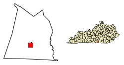
Location of Albany in Clinton County, Kentucky.
|
|
| Country | United States |
| State | Kentucky |
| County | Clinton |
| Area | |
| • Total | 2.28 sq mi (5.90 km2) |
| • Land | 2.27 sq mi (5.89 km2) |
| • Water | 0.01 sq mi (0.01 km2) |
| Elevation | 961 ft (293 m) |
| Population
(2020)
|
|
| • Total | 1,760 |
| • Estimate
(2022)
|
1,733 |
| • Density | 773.97/sq mi (298.82/km2) |
| Time zone | UTC-6 (Central (CST)) |
| • Summer (DST) | UTC-5 (CDT) |
| ZIP code |
42602
|
| Area code(s) | 606 |
| FIPS code | 21-00694 |
| GNIS feature ID | 0485813 |
Albany is a city in Clinton County, Kentucky, in the United States. It's known as a "home rule-class city," which means it has its own local government rules. In 2020, about 1,760 people lived there. Albany is also the county seat of Clinton County, which means it's where the main government offices for the county are located. You can find Albany on U.S. Route 127, about 6 miles (10 km) north of the Tennessee border.
Contents
History of Albany
The town of Albany started around a tavern (a type of inn or pub) that Benjamin Dowell opened in the early 1800s. In 1837, people living there decided that this spot should be the main government center for the county.
Albany officially became a town on January 27, 1838. Most people think it was named after Albany, New York. However, there's a fun local story! It says that when people were voting for the county seat, folks at Dowell's tavern shouted "All for Benny!" This then supposedly became "all Benny," which sounded like "Albany."
During the Civil War, Albany faced attacks from Confederate soldiers. Many buildings, including the courthouse, were burned down. There's a marker in the courthouse square that mentions Champ Ferguson, a local figure from the Civil War.
Geography of Albany
Albany is located in the southern part of Clinton County. It sits at an elevation of about 960 feet (293 meters). The city is at the base of the western edge of the Cumberland Plateau, which is a large, flat area of land that is higher than the surrounding land.
Just northeast of the city, you'll find Albany Rock. This is a part of the plateau that rises to about 1,700 feet (518 meters) high.
The city covers a total area of about 2.28 square miles (5.9 square kilometers). Most of this area is land, with only a very small part being water.
Population Information
| Historical population | |||
|---|---|---|---|
| Census | Pop. | %± | |
| 1860 | 222 | — | |
| 1870 | 163 | −26.6% | |
| 1900 | 234 | — | |
| 1910 | 579 | 147.4% | |
| 1920 | 595 | 2.8% | |
| 1930 | 852 | 43.2% | |
| 1940 | 1,259 | 47.8% | |
| 1950 | 1,920 | 52.5% | |
| 1960 | 1,887 | −1.7% | |
| 1970 | 1,891 | 0.2% | |
| 1980 | 2,083 | 10.2% | |
| 1990 | 2,062 | −1.0% | |
| 2000 | 2,220 | 7.7% | |
| 2010 | 2,033 | −8.4% | |
| 2020 | 1,760 | −13.4% | |
| 2022 (est.) | 1,733 | −14.8% | |
| U.S. Decennial Census | |||
In 2000, Albany had a population of 2,220 people. The population has changed over the years, as you can see in the chart. By 2020, the population was 1,760.
Education in Albany
Schools in Albany
All the schools in Albany are part of the Clinton County School District.
- Early Childhood Center
- Albany Elementary School
- Clinton County Middle School
- Clinton County High School
Libraries in Albany
Albany has a public library where you can borrow books and other materials. It's called the Clinton County Public Library.
Notable People from Albany
- Thomas Bramlette: He was a governor of Kentucky from 1863 to 1867.
- Garlin Murl Conner: A brave soldier in the United States Army during World War II. He served in North Africa and Europe.
- Sam C. Ford: He was the 12th governor of Montana.
- Jeff Hoover: He used to be the Speaker of the House for the Kentucky House of Representatives.
- Preston H. Leslie: He was a Democratic governor of Kentucky and also a territorial governor of Montana.
See also
 In Spanish: Albany (Kentucky) para niños
 | Valerie Thomas |
 | Frederick McKinley Jones |
 | George Edward Alcorn Jr. |
 | Thomas Mensah |


