Monroe County, Kentucky facts for kids
Quick facts for kids
Monroe County
|
|
|---|---|

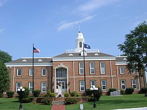
Monroe County courthouse in Tompkinsville
|
|

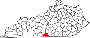
Location within the U.S. state of Kentucky
|
|
 Kentucky's location within the U.S. |
|
| Country | |
| State | |
| Founded | 1820 |
| Named for | James Monroe |
| Seat | Tompkinsville |
| Largest city | Tompkinsville |
| Area | |
| • Total | 332 sq mi (860 km2) |
| • Land | 329 sq mi (850 km2) |
| • Water | 2.7 sq mi (7 km2) 0.8% |
| Population
(2020)
|
|
| • Total | 11,338 |
| • Estimate
(2023)
|
11,306 |
| • Density | 34.15/sq mi (13.186/km2) |
| Time zone | UTC−6 (Central) |
| • Summer (DST) | UTC−5 (CDT) |
| Congressional district | 1st |
Monroe County is a special area in Kentucky, a state in the United States. It's located in a part of Kentucky called the Eastern Pennyroyal Plateau. The main town, or county seat, where the county government is located, is Tompkinsville.
This county is named after President James Monroe. He was the fifth president of the United States. For a long time, Monroe County was a "dry county," meaning you couldn't legally buy or sell alcohol there. But in November 2023, people voted to allow alcohol sales.
Contents
History of Monroe County
Monroe County was created in 1820. It's unique because it's the only county in the entire United States named after a president where its main town is named after that president's vice-president. President James Monroe and his vice-president, Daniel Tompkins, both served from 1817 to 1825.
Civil War Events
During the American Civil War, an important event happened here. On July 9, 1862, Confederate General John Hunt Morgan led a raid into Kentucky. His group, known as Morgan's Raiders, attacked a Union army camp in Monroe County.
The Raiders captured 30 Union soldiers. They also destroyed tents and supplies. They took 20 wagons, 50 mules, 40 horses, and food items like sugar and coffee. After this, they continued their raid, attacking 16 more towns before going back to Tennessee.
Famous Connections
Did you know that a distant cousin of President Abraham Lincoln once lived in what is now Monroe County? Thomas Lincoln (1780–1844), who was Abraham Lincoln's half third cousin, lived near Meshack Creek. He even worked as a constable, a type of law officer, in the early 1800s. In 1810, he moved away from Kentucky to Ohio and Indiana.
Old Mulkey Meetinghouse
Monroe County is home to the Old Mulkey Meetinghouse State Historic Site. This park covers about 20 acres. It features the oldest log meetinghouse in Kentucky, which was built in 1804. This was a time when many people were becoming very religious.
Many soldiers from the American Revolutionary War and early pioneers are buried here. This includes Hannah, the sister of famous explorer Daniel Boone. The meetinghouse itself is interesting because it has twelve corners, shaped like a cross. It also has three doors, which are meant to symbolize the Holy Trinity. The Old Mulkey Church was first called the Mill Creek Baptist Church. It was started by a group of early Baptists from North and South Carolina, led by Philip Mulkey. This historic site became part of Kentucky's park system in 1931.
Geography of Monroe County
Monroe County covers a total area of about 332 square miles. Most of this area, about 329 square miles, is land. The rest, about 2.7 square miles, is water.
Nearby Counties
Monroe County shares its borders with several other counties:
- Barren County (to the northwest)
- Metcalfe County (to the northeast)
- Cumberland County (to the east)
- Clay County, Tennessee (to the southeast)
- Macon County, Tennessee (to the southwest)
- Allen County (to the west)
People of Monroe County
| Historical population | |||
|---|---|---|---|
| Census | Pop. | %± | |
| 1830 | 5,340 | — | |
| 1840 | 6,526 | 22.2% | |
| 1850 | 7,756 | 18.8% | |
| 1860 | 8,551 | 10.3% | |
| 1870 | 9,231 | 8.0% | |
| 1880 | 10,741 | 16.4% | |
| 1890 | 10,989 | 2.3% | |
| 1900 | 13,053 | 18.8% | |
| 1910 | 13,663 | 4.7% | |
| 1920 | 14,214 | 4.0% | |
| 1930 | 13,077 | −8.0% | |
| 1940 | 14,070 | 7.6% | |
| 1950 | 13,770 | −2.1% | |
| 1960 | 11,799 | −14.3% | |
| 1970 | 11,642 | −1.3% | |
| 1980 | 12,353 | 6.1% | |
| 1990 | 11,401 | −7.7% | |
| 2000 | 11,756 | 3.1% | |
| 2010 | 10,963 | −6.7% | |
| 2020 | 11,338 | 3.4% | |
| 2023 (est.) | 11,306 | 3.1% | |
| U.S. Decennial Census 1790-1960 1900-1990 1990-2000 2010-2021 |
|||
In 2000, there were 11,756 people living in Monroe County. These people lived in 4,741 homes. About 3,380 of these were families. The county had about 36 people living in each square mile.
Most of the people in the county were White (about 95.57%). A smaller number were Black or African American (about 2.76%). Other groups made up smaller parts of the population. About 1.45% of the people were Hispanic or Latino.
Looking at the age groups in 2000, about 23.90% of the population was under 18 years old. About 15.30% of the people were 65 years old or older. The average age in the county was 38 years.
Towns and Communities
Cities
- Fountain Run
- Gamaliel
- Tompkinsville (the main county town)
Unincorporated Communities
These are smaller places that are not officially cities:
- Akersville
- Alexander
- Boyd
- Bugtussle
- Center Point
- Coe
- Coon’s Foot
- Cyclone
- Ebenezer
- Emberton
- Flippin
- Gum Tree
- Hestand
- Jeffrey
- Lamb
- Meshack
- Mount Hermon
- Mud Lick
- Otia
- Persimmon
- Raydure
- Rockbridge
- Stringtown
- Sulphur Lick
- Vernon
See also
 In Spanish: Condado de Monroe (Kentucky) para niños
 | William M. Jackson |
 | Juan E. Gilbert |
 | Neil deGrasse Tyson |

