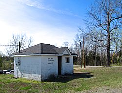
Gum Tree, Kentucky facts for kids
Quick facts for kids
Gum Tree, Kentucky
|
|
|---|---|

Gum Tree Voting House
|
|
| Country | United States |
| State | Kentucky |
| County | Monroe |
| Elevation | 938 ft (286 m) |
| Time zone | UTC-6 (Central (CST)) |
| • Summer (DST) | UTC-5 (CDT) |
| ZIP codes |
42167
|
| GNIS feature ID | 508148 |
Gum Tree is a small place in Monroe County, Kentucky, Kentucky, United States. It's called an unincorporated community. This means it's a group of homes and businesses that don't have their own local government, like a city or town does. Instead, it's part of the larger county.
Where is Gum Tree, Kentucky?
Gum Tree is located in the beautiful state of Kentucky. It's in Monroe County. You can find it where three roads meet: Kentucky Route 678, Kentucky Route 870, and Kentucky Route 1366.
Nearby Towns
Gum Tree is northwest of Tompkinsville. It is also north of Gamaliel. To its west is Flippin, Kentucky, and to its east is Mud Lick, Kentucky.
Voting in Gum Tree
Even though Gum Tree doesn't have its own city government, it's still an important place for local elections. It is home to one of Monroe County's voting precincts. A voting precinct is a special area where people go to cast their votes.
How Many Voters?
As of 2014, more than 900 people were registered to vote in the Gum Tree precinct. This means many people in the area participate in choosing their leaders.
 | DeHart Hubbard |
 | Wilma Rudolph |
 | Jesse Owens |
 | Jackie Joyner-Kersee |
 | Major Taylor |


