Grimsley, Tennessee facts for kids
Quick facts for kids
Grimsley, Tennessee
|
|
|---|---|

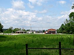
Post office and Beaty General Store in Grimsley
|
|
| Country | United States |
| State | Tennessee |
| County | Fentress |
| Area | |
| • Total | 10.89 sq mi (28.20 km2) |
| • Land | 10.89 sq mi (28.20 km2) |
| • Water | 0.00 sq mi (0.00 km2) |
| Elevation | 1,749 ft (533 m) |
| Population
(2020)
|
|
| • Total | 1,219 |
| • Density | 111.98/sq mi (43.23/km2) |
| Time zone | UTC-5 (CST) |
| • Summer (DST) | UTC-4 (CST) |
| ZIP code |
38565
|
| Area code(s) | 931 |
| GNIS feature ID | 1286299 |
| FIPS code | 47-31420 |
Grimsley is a small community in Fentress County, Tennessee, United States. It is known as a census-designated place (CDP). This means it's an area that the U.S. Census Bureau defines for gathering population data. In 2020, about 1,219 people lived in Grimsley. The area has its own ZIP code, which is 38565.
Contents
Exploring Grimsley's Location
Grimsley is found in the southern part of Fentress County. It sits on a high area called the Cumberland Plateau. This plateau is a large, flat area of land that is much higher than the land around it.
Grimsley's Elevation and Rivers
The main part of Grimsley is on high ground. Its elevation is about 1,700 to 1,800 feet above sea level. To the west, the land drops sharply into a deep valley. This valley is home to the East Fork of the Obey River. The bottom of this valley is much lower, around 800 to 900 feet high. To the east, Grimsley follows the valley of the North Prong of Clear Fork. This area is about 1,600 feet high. Both of these rivers flow into the Cumberland River. A watershed is an area of land where all the water drains into a common river or lake.
Main Roads in Grimsley
U.S. Route 127 is the most important road in Grimsley. If you drive north on this road for about 12 miles, you will reach Jamestown. Jamestown is the main town in Fentress County. If you drive south for about 6.5 miles, you will get to Clarkrange.
Another important road is Tennessee State Route 85. This road runs along the southwestern edge of Grimsley. It goes down into the valley of the East Fork of the Obey River. This road has many sharp turns, called switchbacks. It leads about 33 miles to Livingston.
Grimsley's Size
The U.S. Census Bureau says that Grimsley covers an area of about 28.2 square kilometers. All of this area is land.
Grimsley's Population Facts
| Historical population | |||
|---|---|---|---|
| Census | Pop. | %± | |
| 2020 | 1,219 | — | |
| U.S. Decennial Census | |||
The population of Grimsley was 1,219 people in 2020. This information comes from the 2020 United States Census. A census is a count of all the people living in a country. It helps us understand how many people live in different places.
Grimsley's Community Makeup
In 2020, there were 1,219 people living in Grimsley. These people lived in 357 different homes, and 252 of these were families. Most of the people living in Grimsley were White, making up about 96% of the population. There were also smaller numbers of people from other backgrounds, including Black or African American, Native American, Asian, and people of mixed races. About 0.9% of the population identified as Hispanic or Latino.
See also
 In Spanish: Grimsley (Tennessee) para niños
 | Selma Burke |
 | Pauline Powell Burns |
 | Frederick J. Brown |
 | Robert Blackburn |


