
Van Buren County, Tennessee facts for kids
Quick facts for kids
Van Buren County
|
||
|---|---|---|

Van Buren County Courthouse in Spencer
|
||
|
||

Location within the U.S. state of Tennessee
|
||
 Tennessee's location within the U.S. |
||
| Country | ||
| State | ||
| Founded | January 3, 1840 | |
| Named for | Martin Van Buren | |
| Seat | Spencer | |
| Largest town | Spencer | |
| Area | ||
| • Total | 275 sq mi (710 km2) | |
| • Land | 273 sq mi (710 km2) | |
| • Water | 1.1 sq mi (3 km2) 0.4%% | |
| Population
(2020)
|
||
| • Total | 6,168 |
|
| • Density | 20/sq mi (8/km2) | |
| Time zone | UTC−6 (Central) | |
| • Summer (DST) | UTC−5 (CDT) | |
| Area code | 423, 931 | |
| Congressional district | 6th | |

Van Buren County is a county located in the state of Tennessee in the United States. In 2020, about 6,168 people lived there. This makes it the second-smallest county in Tennessee by population. The main town and county seat is Spencer.
Contents
History of Van Buren County
Van Buren County was created in 1840. It was formed from parts of three other counties: White, Warren, and Bledsoe. The county was named after Martin Van Buren, who was a President of the United States.
The county seat, Spencer, was once home to Burritt College. This college was special because it was one of the first schools in the southern U.S. that allowed both boys and girls to study together. This happened in the 1800s and early 1900s.
Geography of Van Buren County
Van Buren County covers about 275 square miles (712 square kilometers). Most of this area is land, with only a small part being water. The county sits on the western edge of the Cumberland Plateau. The eastern part of the county is on top of this high, flat area. The western part is on the lower Highland Rim.
The Caney Fork river is the main waterway in the county. It forms part of the northern border with White County. The Rocky River flows into the Caney Fork and forms part of the western border with Warren County. Cane Creek, another stream, drains the area around Fall Creek Falls.
Amazing Caves in Van Buren County
Big Bone Cave is found in the northwest part of Van Buren County. It is one of Tennessee's most famous and historic caves. Long ago, Native Americans mined this cave for gypsum and salts. Later, during the War of 1812 and the American Civil War, it was a big source of saltpeter. Saltpeter was used to make gunpowder.
The cave got its name because miners found the skeleton of a Giant Ground Sloth there in 1811. Many old wooden tools from the saltpeter mining days are still in the cave. They are very well preserved because the cave is extremely dry.
Van Buren County has more than 850 known caves! This means it has over 3 caves per square mile. This makes it one of the places with the most caves in the world.
Counties Nearby
- White County (north)
- Cumberland County (northeast)
- Bledsoe County (east)
- Sequatchie County (south)
- Warren County (west)
Protected Natural Areas
- Big Bone Cave State Natural Area
- Bledsoe State Forest (part)
- Fall Creek Falls State Natural Area (part)
- Fall Creek Falls State Resort Park (part)
Population of Van Buren County
| Historical population | |||
|---|---|---|---|
| Census | Pop. | %± | |
| 1850 | 2,674 | — | |
| 1860 | 2,581 | −3.5% | |
| 1870 | 2,725 | 5.6% | |
| 1880 | 2,933 | 7.6% | |
| 1890 | 2,863 | −2.4% | |
| 1900 | 3,126 | 9.2% | |
| 1910 | 2,784 | −10.9% | |
| 1920 | 2,624 | −5.7% | |
| 1930 | 3,516 | 34.0% | |
| 1940 | 4,090 | 16.3% | |
| 1950 | 3,985 | −2.6% | |
| 1960 | 3,671 | −7.9% | |
| 1970 | 3,758 | 2.4% | |
| 1980 | 4,728 | 25.8% | |
| 1990 | 4,846 | 2.5% | |
| 2000 | 5,508 | 13.7% | |
| 2010 | 5,548 | 0.7% | |
| 2020 | 6,168 | 11.2% | |
| U.S. Decennial Census 1790-1960 1900-1990 1990-2000 2010-2020 2020 |
|||

2020 Population Count
| Group | Number | Percentage |
|---|---|---|
| White | 5,866 | 95.1% |
| Black or African American | 20 | 0.32% |
| Native American | 7 | 0.11% |
| Asian | 10 | 0.16% |
| Pacific Islander | 1 | 0.02% |
| Other/Mixed | 181 | 2.93% |
| Hispanic or Latino | 83 | 1.35% |
In 2020, there were 6,168 people living in Van Buren County. There were 2,141 households and 1,545 families.
2010 Population Count
In 2010, the county had 5,548 people and 2,096 households. The population density was about 20 people per square mile. Most people (97.5%) were White. About 0.7% were Black or African American.
About 29.3% of households had children under 18 living with them. Many households (54.9%) were married couples living together. The average household had 2.43 people. Most homes (82.6%) were owned by the people living in them.
The population was spread out by age. About 23.2% were up to 19 years old. The median age was 44.5 years. Women made up about 50.2% of the population.
Fun Things to Do
Van Buren County is home to part of Fall Creek Falls State Resort Park. This park is a great place for outdoor activities and seeing beautiful waterfalls.
Communities in Van Buren County
Town
- Spencer (This is the main town and county seat.)
Small Communities (Unincorporated)
Education
The public schools in Van Buren County are managed by Van Buren County Schools.
Images for kids
-
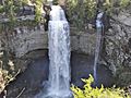
Fall Creek Falls
-
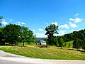
Hills near Spencer


See also
 In Spanish: Condado de Van Buren (Tennessee) para niños
