Rocky River (Tennessee) facts for kids
Quick facts for kids Rocky River |
|
|---|---|

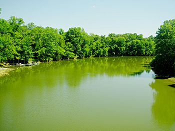
View from the Bone Cave Road bridge
|
|
| Country | United States |
| State | Tennessee |
| Physical characteristics | |
| Main source | Jakes Mountain in Sequatchie County 1,880 ft (570 m) 35°31′57″N 85°29′10″W / 35.53250°N 85.48611°W |
| River mouth | Great Falls Lake (Caney Fork) at Rock Island 804 ft (245 m) 35°47′37″N 85°36′9″W / 35.79361°N 85.60250°W |
| Length | 31 mi (50 km) |
| Basin features | |
| Basin size | 111 sq mi (290 km2) |
The Rocky River is a 31-mile (50 km) long stream in the middle-eastern part of Tennessee, United States. It flows into the Caney Fork River. The Rocky River is part of a much larger water system that includes the Cumberland River, Ohio River, and Mississippi River. The lower section of the river becomes part of Great Falls Lake. This lake was formed by the Great Falls Dam, which is close to where the Rocky River meets the Caney Fork.
Contents
River's Journey: From Mountain to Lake
The Rocky River starts high up on Jakes Mountain. This mountain is about 2,204 feet (672 meters) tall. It's located in Sequatchie County, on top of the Cumberland Plateau. Soon after it begins, the river flows into a small lake called Studer Lake. It then travels north through rough, hilly areas.
The river crosses into Van Buren County. Here, it passes a historic spot known as the "Rocky River Crossing." This place was once part of the Trail of Tears. The river then drops about 900 feet (274 meters) in less than four miles. This makes the water flow much faster. The river continues north, surrounded by the high walls of the Cumberland Plateau and Barnett Mountain.
As it gets closer to the Goodbars community, the river flows under State Highway 30. It then forms many curves, like big loops, in the land. After passing under Bone Cave Road and U.S. Highway 70, the river reaches the calm waters of Great Falls Lake. It joins the Caney Fork River about a mile upstream from the Great Falls Dam. This meeting point is where three counties come together: Warren, Van Buren, and White counties.
River's Drainage Area
The area that drains water into the Rocky River is about 111 square miles (287 square kilometers). This is called its watershed. A special line called the Tennessee Valley Divide runs across Jakes Mountain. This line separates the waters that flow into the Cumberland River from those that flow into the Tennessee River. Streams on the north side of Jakes Mountain feed the Rocky River. Streams on the south side flow into the Sequatchie River.
Several ridges, like Long Mountain and Barnett Mountain, also help shape the watershed. They separate the Rocky River's water from the water of the Collins River to the west.
Some important smaller streams flow into the Rocky River. These are called tributaries. From the west, Harper Branch, Sycamore Branch, and Dyer Gulch Creek join the river. From the east, Samples Fork, Rocky Branch, and Pine Branch add their water. Laurel Creek, which flows into the river near Goodbars, drains part of the town of Spencer.
River's Past: History and Landmarks
Rock Island Rock Island is a small island where the Rocky River meets the Caney Fork. It was a very important place for early settlers. Two old Native American trails, the Chickamauga Trail and the Black Fox Trail, met near this island. A battle even took place here in 1793, during the Cherokee–American wars.
Trail of Tears Connection In the 1800s, a major road called Higgenbotham's Trace crossed the Rocky River near Pleasant Hill Cemetery. In 1838, the northern route of the Trail of Tears followed this road. This was when the Cherokee people were forced to move from their homes to Oklahoma. While they camped by the Rocky River, a Cherokee leader named Junaluska and some others tried to go back home. They were caught and arrested. Today, the Rocky River Crossing still looks much like it did back then. It is now a protected historic site.
Bridges and Crossings Many places along the Rocky River were used as fords (shallow places where people could cross). Brights Ford and Hash Ford (also called Indian Ford) were two well-known ones. A wooden bridge was built at Hash Ford in the mid-1800s, but a flood destroyed it in 1872. Later, as part of the Great Falls Dam project, the Tennessee Electric Power Company built two new bridges: the Yost Bridge in 1915 and the Blanks Bridge in 1916. A bridge for Tennessee Highway 30 was built in the early 1920s.
Protecting the River: Ecology and Habitat
In the past, mining in the upper Rocky River area caused problems for the river. Dirt and mud from the mines, called siltation, damaged parts of the river. This also threatened two special fish species that live there: the bluemask darter and the slender chub. Both of these fish are protected by law.
Today, people are working to help the river heal. One effort is building fences to keep livestock (like cows) away from the riverbanks. This allows trees and plants to grow back along the river, creating a healthy riparian zone (the area next to the river). Workers are also filling in and planting new plants on the old mining sites. These efforts help make the Rocky River a better home for its wildlife.
 | Calvin Brent |
 | Walter T. Bailey |
 | Martha Cassell Thompson |
 | Alberta Jeannette Cassell |

