Warren County, Tennessee facts for kids
Quick facts for kids
Warren County
|
||
|---|---|---|

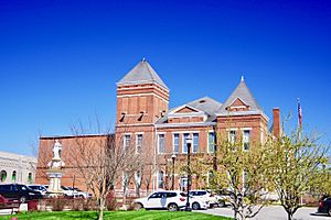
Warren County Courthouse in McMinnville
|
||
|
||

Location within the U.S. state of Tennessee
|
||
 Tennessee's location within the U.S. |
||
| Country | ||
| State | ||
| Founded | 1807 | |
| Named for | Joseph Warren | |
| Seat | McMinnville | |
| Largest city | McMinnville | |
| Area | ||
| • Total | 434 sq mi (1,120 km2) | |
| • Land | 433 sq mi (1,120 km2) | |
| • Water | 1.4 sq mi (4 km2) 3%% | |
| Population
(2020)
|
||
| • Total | 40,953 |
|
| • Density | 92/sq mi (36/km2) | |
| Time zone | UTC−6 (Central) | |
| • Summer (DST) | UTC−5 (CDT) | |
| Congressional districts | 4th, 6th | |
Warren County is a county in the state of Tennessee, U.S.. It is located on the Cumberland Plateau in Middle Tennessee. In 2020, about 40,953 people lived there. The main town and county seat is McMinnville. Warren County is part of the McMinnville, TN area.
Contents
History of Warren County
Warren County was created in 1807. It was formed from a part of White County. The county is named after Joseph Warren. He was a brave soldier and general in the American Revolution.
The state rules in 1834 said new counties could not be too close to an old county's main town. Because of this, Warren County has a special round shape. Five counties were formed from parts of Warren County. These are Grundy, Van Buren, Cannon, Coffee, and DeKalb counties. Their borders are exactly 12 miles from McMinnville, Warren County's seat.
Warren County was once home to several saltpeter mines. Saltpeter is a key ingredient for making gunpowder. It was found in local caves. Hubbards Cave was a very important mining spot. Other caves like Henshaw Cave and Solomon Saltpeter Cave also had smaller mining operations. Most of this mining happened during the War of 1812 and the American Civil War.
The county was mostly used for farming crops like tobacco and hemp. Some families in the county had enslaved people working for them. In February 1861, Warren County citizens voted to leave the United States. At that time, most voters in Tennessee wanted to stay in the Union.
However, when President Abraham Lincoln asked Tennessee to send soldiers to fight against the Southern states in April 1861, many people in Tennessee felt this was against the rules of the U.S. Constitution. So, in June 1861, Warren County voted again to leave the Union. Most counties in Tennessee also voted this way.
Many men from Warren County joined the fight. They served in units like the 16th Tennessee Infantry. This group was led by Colonel John Houston Savage from McMinnville. There is a monument near the county courthouse. It honors the men who served and died in the 16th Regiment.
Geography and Nature
Warren County covers about 434 square miles. Most of this area is land. Only a small part, about 1.4 square miles, is water. The county is located on the eastern edge of the Highland Rim, close to the Cumberland Plateau.
The Caney Fork river forms part of the county's northern border. The Rocky River flows along part of the eastern border. The Collins River flows through the county. The Barren Fork river, which is a branch of the Collins, flows through McMinnville.
Cardwell Mountain is a large natural landmark. It is about five miles east of McMinnville. This mountain is known for Cumberland Caverns. This is a very long cave system located underneath the mountain.
Nearby Counties
- DeKalb County (north)
- White County (northeast)
- Van Buren County (east)
- Sequatchie County (southeast)
- Grundy County (south)
- Coffee County (southwest)
- Cannon County (northwest)
Main Roads in Warren County
 U.S. Route 70S
 State Route 8
 State Route 30
 State Route 55
 State Route 56
 State Route 108
 State Route 136
Protected Natural Areas
- Hubbard's Cave State Natural Area
- Morrison Meadow State Natural Area
- Rock Island State Park (part of it)
People of Warren County
| Historical population | |||
|---|---|---|---|
| Census | Pop. | %± | |
| 1810 | 5,725 | — | |
| 1820 | 10,348 | 80.8% | |
| 1830 | 15,210 | 47.0% | |
| 1840 | 10,803 | −29.0% | |
| 1850 | 10,179 | −5.8% | |
| 1860 | 11,147 | 9.5% | |
| 1870 | 12,714 | 14.1% | |
| 1880 | 14,079 | 10.7% | |
| 1890 | 14,413 | 2.4% | |
| 1900 | 16,410 | 13.9% | |
| 1910 | 16,534 | 0.8% | |
| 1920 | 17,306 | 4.7% | |
| 1930 | 20,209 | 16.8% | |
| 1940 | 19,764 | −2.2% | |
| 1950 | 22,271 | 12.7% | |
| 1960 | 23,102 | 3.7% | |
| 1970 | 26,972 | 16.8% | |
| 1980 | 32,653 | 21.1% | |
| 1990 | 32,992 | 1.0% | |
| 2000 | 38,276 | 16.0% | |
| 2010 | 39,839 | 4.1% | |
| 2020 | 40,953 | 2.8% | |
| U.S. Decennial Census 1790-1960 1900-1990 1990-2000 2010-2014 |
|||
2020 Census Information
| Race | Number | Percentage |
|---|---|---|
| White (not Hispanic) | 33,980 | 82.97% |
| Black or African American (not Hispanic) | 1,090 | 2.66% |
| Native American | 84 | 0.21% |
| Asian | 258 | 0.63% |
| Pacific Islander | 10 | 0.02% |
| Other/Mixed | 1,588 | 3.88% |
| Hispanic or Latino | 3,943 | 9.63% |
In 2020, there were 40,953 people living in Warren County. There were 15,727 households and 10,167 families.
Fun Things to Do
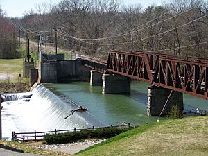
Rock Island State Park is on the border with White County. This park has the Tennessee Valley Authority's Great Falls Dam. You can find many hiking trails here. It's also a great place for whitewater rafting.
Cumberland Caverns is east of McMinnville. It is Tennessee's biggest show cave. It has 27.6 miles of passages. You can see some of the largest cave rooms in eastern North America here. Cumberland Caverns is the 15th longest cave in the United States.
Hubbard's Cave is in the county. It is the largest winter home for gray bats in Tennessee. Over 100,000 bats live there. The cave is owned by the Nature Conservancy. It is protected to keep the bats safe, as they are an endangered species.
Falcon Rest is an old house in McMinnville. It was built in 1896 by Clay Faulkner. It is a Victorian mansion. It is listed on the National Register of Historic Places. You can visit it as a museum. Clay Faulkner's father's house, Falconhurst, is also in McMinnville and is on the National Register.
Towns and Communities

City
- McMinnville (county seat)
Towns
Other Communities
- Berea
- Bratchers Crossroads
- Campaign
- Daylight
- Irving College
- Midway
- Rock Island
- Shady Rest
- Shellsford
- Smartt
- Spring Creek
- Stewart Chapel
See also
 In Spanish: Condado de Warren (Tennessee) para niños
 | Kyle Baker |
 | Joseph Yoakum |
 | Laura Wheeler Waring |
 | Henry Ossawa Tanner |


