Rock Island State Park (Tennessee) facts for kids
Quick facts for kids Rock Island State Park |
|
|---|---|
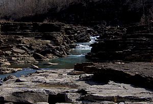
The Caney Fork in the Great Falls Gorge
|
|
| Location | Rock Island, Warren County and White County, Tennessee, United States |
| Area | 883 acres (3.57 km2) |
| Created | 1969 |
| Owned by | Tennessee Valley Authority |
| Managed by | Tennessee Department of Environment and Conservation |
| Open | Year around |
Rock Island State Park is a fun state park in Tennessee, located in the southeastern part of the United States. It's found in both Warren County and White County. The park gets its name from the nearby community of Rock Island, Tennessee. This community was named after an island in the Caney Fork River. This island is located upstream from where the Collins River joins it and near the Great Falls Dam.
Rock Island State Park is mostly on a piece of land that sticks out into the water. This land is formed by the two rivers, the Caney Fork and the Collins River, meeting. The park stretches downstream to the beginning of Center Hill Lake. It covers about 883 acres (3.57 km²) of land. The park is managed by the Tennessee Department of Environment and Conservation.
Contents
Exploring the Park's Location
The Caney Fork River starts high up on the Cumberland Plateau. It then flows west and drops down to an area called the Highland Rim. Here, it enters White County. As it continues, the river gets bigger. It picks up water from Cane Creek and the Calfkiller River.
Near a town called Walling, the Caney Fork turns south for a bit. It then takes in the Rocky River. After that, it turns west again. Just a couple of miles later, the Collins River joins the Caney Fork. This is where the amazing Great Falls Gorge begins. After the gorge, the river flows into the upper part of Center Hill Lake. From there, it heads north towards the Cumberland River near Carthage.
The Collins River also starts on the Cumberland Plateau. It begins several miles south of Rock Island State Park. It flows north through a flat area known as "the Barrens." Then it calms down as it reaches the eastern part of McMinnville. The Collins River almost meets the Caney Fork right across from the Great Falls Dam power plant. But instead, it bends south. This bend creates the peninsula where Rock Island State Park is now located.
The island that gave the park its name is in the Caney Fork River. It's about 1 mile (1.6 km) upstream from the Great Falls Dam. The community of Rock Island is located east of the state park, along Great Falls Lake.
Cool Natural and Historic Spots
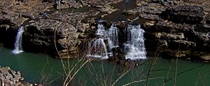
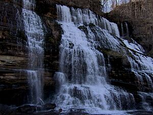
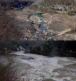
- The Great Falls Gorge: This amazing gorge is found between the northern part of Great Falls Dam and its powerhouse. It features Great Falls, which is a series of waterfalls. These waterfalls drop into the Caney Fork when the river's water levels are low. When there's a lot of water, the gorge fills up, and the waterfalls disappear under the water. A short path leads from the parking lot right to the bottom of the gorge.
- Twin Falls: This is a beautiful waterfall that flows out of a cave. It spills into the Caney Fork, just past the powerhouse. Twin Falls was actually created by the Great Falls Dam. When the dam was built, it caused the Collins River to rise. This rising water started to seep into caves on the south side of Rock Island. The water then found its way out at the falls on the north side.
Historic Buildings to See
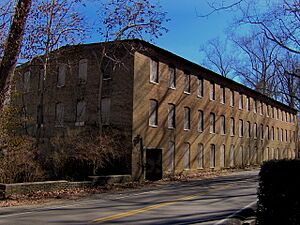
- The Great Falls Cotton Mill: This old mill is also called the Falls City Cotton Mill. It sits on the cliffs above Great Falls. The mill was built in 1892 and worked until 1902. It was added to the National Register of Historic Places in 1982. This means it's an important historical site.
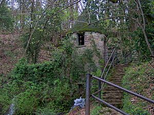
- The Spring Castle: This unique building is right next to the cotton mill. It's like a very large version of a spring house. Workers from the cotton mill used it to keep things cool, like a natural refrigerator. It was probably built in the 1890s.
- The Great Falls Dam: This dam is located on the Caney Fork River. You can find it near the park's TN-136 entrance. The dam was built between 1915 and 1916. In 1990, it was also added to the National Register of Historic Places.
A Look Back in Time
Factories and Floods
After the American Civil War, many people tried to use the powerful Caney Fork River. They wanted to build factories that used water power. But the river often flooded very quickly and strongly. This made it hard for businesses to succeed. A local poet, R.P. Hudson, wrote about this time:
Playful river, ever laughing,
Pleading river, always calling,
Rushing river, now unwieldy,
Wild, deep river, oft defiant.
The Bosson Mill was one of the first big mills here. It was built around the time of the Civil War. Water from the falls powered a gristmill on the first floor. This mill ground grain. On the second floor, there was a carding factory. This factory prepared cotton or wool. Water was also sent to a sawmill downstream. The Bosson Mill made some money, but a big flood in 1882 destroyed it.
In 1881, a railroad was completed, bringing bigger businesses to the area. In the mid-1880s, a businessman named Asa Faulkner bought the Bosson Mill land. He planned to build a large cotton mill. Faulkner and his partners raised $30,000. They started the Falls City Cotton Mill Company in 1892. The company built a special wheelhouse to get power from Great Falls. This power was sent to the cotton mill, which was higher up on the cliffs.
The company also built a small town for its workers. It was called "Falls City." This town had its own post office and a general store. The spring castle, which you can still see today, was also part of this town. But in 1902, the Caney Fork flooded again. The mill itself was safe because it was high up. However, the wheelhouse was completely washed away. The flood also destroyed the company's toll bridge over the river. After this, the company closed the mill, and the town slowly disappeared.
In 1904, the Great Falls Power Company bought the Great Falls property. They wanted to build a dam on the Caney Fork. Their goal was to provide electricity to the Nashville area. They tried to build several temporary dams, but floods in 1914 destroyed all of them. The company often had money problems. Finally, they started building the Great Falls Hydroelectric Plant in 1915. The dam began working in 1917.
The Tennessee Electric Power Company (TEPCo) bought the Great Falls Power Company in 1922. They made the dam three times more powerful. In 1929, a huge flood, known as the Good Friday Flood, hit the Caney Fork. The river reached record high levels. The flood destroyed the dam's substation and flooded its powerhouse. But the main dam held strong! In 1939, the Tennessee Valley Authority bought the TEPCO Dam. They still operate it today.
The State Park is Born
When the Great Falls Dam created a lake, it opened up many fun activities at Rock Island. The Webb Hotel opened in the area in 1920. Later in the 1920s, several cozy cabins were built. By the 1930s, Rock Island had become a popular spot for fishing vacations.
Rock Island State Park was officially created in 1969.
The Rock Island area was also used for many outdoor scenes and stunts in the 1994 Sylvester Stallone film called The Specialist.
Rock Island State Park Today
Today, Rock Island State Park has 10 cabins and 60 campsites where you can stay. It also has a boat ramp for launching boats. The part of the park near Center Hill Lake has a natural sand beach. There's also a popular fishing spot called the "Blue Hole."
The park offers great hiking trails. Two trails lead to the north and south sides of the Great Falls Gorge. There's also a 3-mile (4.8 km) trail that runs along the Collins River. While hiking, you might see deer, woodpeckers, and beautiful wildflowers.
In recent years, Rock Island State Park has become a favorite place for kayakers. They love to use the river for playboating. Below Great Falls Dam, there are a series of rapids. These rapids have a special "hole" in the water that stays in place. This allows playboaters to practice their whitewater kayaking skills. They can ride the wave, spin, roll, and do other cool tricks.
Rock Island State Park also helps manage the Big Bone Cave State Natural Area. This cave is located a few miles east in Van Buren County.
 | Selma Burke |
 | Pauline Powell Burns |
 | Frederick J. Brown |
 | Robert Blackburn |


