Calfkiller River facts for kids
Quick facts for kids Calfkiller River |
|
|---|---|

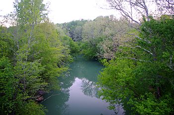
The Calfkiller River near Sparta
|
|
| Country | United States |
| State | Tennessee |
| Physical characteristics | |
| Main source | Stamps Hollow near Monterey 980 ft (300 m) 36°06′20″N 85°18′31″W / 36.10556°N 85.30861°W |
| River mouth | Great Falls Lake (Caney Fork) south of Doyle 794 ft (242 m) 35°49′13″N 85°28′48″W / 35.82028°N 85.48000°W |
| Length | 42.4 mi (68.2 km) |
| Basin features | |
| Basin size | 175 sq mi (450 km2) |
The Calfkiller River is a stream in the east-central part of Middle Tennessee in the United States. It is about 42.4-mile-long (68.2 km). The river flows into the Caney Fork. It is also part of the larger Cumberland, Ohio, and Mississippi river systems. People believe the river got its name from a Cherokee chief who lived in the area long ago.
Contents
Exploring the Calfkiller River's Path
The Calfkiller River starts at the bottom of the Cumberland Plateau. This is just southwest of Monterey in eastern Putnam County. Several smaller streams come together here to form the river. Some of these streams are held back by dams, like the one that creates Monterey Lake.
How the River Flows South
The river then flows south, cutting a wide valley through a hilly area. State Highway 84, also known as Calfkiller Highway, runs mostly along the western side of the river's upper part.

When the river enters White County, its valley gets wider. It turns southwest and goes through many small towns. South of Sparta, the river goes under Highway 84. This highway then follows the river's east bank.
The River Through Sparta
In Sparta, the river continues south. It has steep banks, especially on the east side. The city of Sparta has a park along the west bank of the river. This park is on both sides of the US 70 bridge. The Old Sparta Cemetery is on a hill in downtown Sparta. From there, you can see a great view of this part of the river.
Where the Calfkiller Ends Its Journey
Just south of Sparta, the river makes a sharp turn around the Camp Heights area. Then it turns south again. The river flows over an old dam that was once used by the Sparta Hydroelectric Plant. It then goes under State Highway 111, which follows the river's eastern bank for several miles.
The river continues through rural White County. It passes about a mile east of Doyle. Finally, it flows into the Caney Fork River. This part of the Caney Fork is called Great Falls Lake. It forms the border between White and Van Buren County.
Understanding the Calfkiller River's Watershed
The Calfkiller River's watershed covers 175 sq mi (450 km2). A watershed is the area of land where all the water drains into a specific river or lake. Many streams that feed the Calfkiller River start on top of the Cumberland Plateau.
Key Streams Joining the River
- Whetstone Creek: This creek is one of the river's starting points.
- Bridge Creek: It flows into the river just south of the Putnam-White county line.
- Doe Creek: This creek joins the river near the Big Spring community.
- Wildcat Creek: It empties into the river near Sparta. Wildcat Creek is famous for its 30-foot (9 m) waterfall, which you can see from Highway 70 east of town.
Streams that join the river from its western side include Plum Creek and Cherry Creek, near the Yankeetown community. Mill Creek also joins the river near its source.
A Look at the Calfkiller River's Past
The Calfkiller River has a rich history. It is believed to be named after a Cherokee chief. He lived in the valley when the first European-American settlers arrived around 1800.
Early Uses of the River
In the early 1800s, settlers used the river's power. They built many small gristmills along its banks. These mills used the river to grind grain. Before the Civil War, there was also an iron works and a cotton mill along the river. These were near where the TN-111 bridge is today.
The River During the Civil War
Several small battles happened along the Calfkiller River during the Civil War.
- On August 9, 1863, Union soldiers fought Confederate scouts near Wildcat Creek.
- On November 30, 1863, Confederate fighters tried to surprise Union soldiers at Yankeetown but failed.
- On February 22, 1864, Confederates attacked Union soldiers along the river. This event was called the "Battle of Dug Hill."
A Confederate leader named Champ Ferguson lived in the Calfkiller Valley. He is buried in France Cemetery, which is along the river.
Electricity from the River
In 1902, the Sparta Light and Power Company built a small power plant. It used a waterwheel to make electricity. After this plant burned down in 1907, a new, more modern plant was built. This new plant used a concrete dam to send water through a channel to a powerhouse. The plant worked until the 1930s. At that time, the Tennessee Valley Authority started providing electricity to the area from larger power projects. The old dam can still be seen from the TN-111 bridge. It is now listed on the National Register of Historic Places because of its historical importance.
 | Claudette Colvin |
 | Myrlie Evers-Williams |
 | Alberta Odell Jones |

