Greene County, Tennessee facts for kids
Quick facts for kids
Greene County
|
|||
|---|---|---|---|

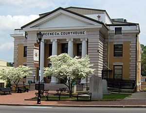
Greene County Courthouse in Greeneville
|
|||
|
|||

Location within the U.S. state of Tennessee
|
|||
 Tennessee's location within the U.S. |
|||
| Country | |||
| State | |||
| Founded | 1783 | ||
| Named for | Nathanael Greene | ||
| Seat | Greeneville | ||
| Largest town | Greeneville | ||
| Area | |||
| • Total | 624 sq mi (1,620 km2) | ||
| • Land | 622 sq mi (1,610 km2) | ||
| • Water | 2.0 sq mi (5 km2) 0.3%% | ||
| Population
(2020)
|
|||
| • Total | 70,152 |
||
| • Density | 111/sq mi (43/km2) | ||
| Time zone | UTC−5 (Eastern) | ||
| • Summer (DST) | UTC−4 (EDT) | ||
| Congressional district | 1st | ||
Greene County is a county located in eastern Tennessee, a state in the United States. In 2020, about 70,152 people lived there. The main town, or county seat, is Greeneville. Greene County is also part of the Greeneville, TN area, which is a smaller city area.
Contents
History of Greene County
Greene County started as a settlement called "Nolichucky." A pioneer named Jacob Brown set it up in the early 1770s. He leased the land from the Cherokee people. This settlement worked closely with the Watauga settlement, which was near what is now Elizabethton.
After the United States became its own country, Greene County was officially created in 1783. It was formed from an older area called Washington County, North Carolina. The county is named after Major General Nathanael Greene. He was an important general in the Continental Army during the American Revolutionary War.
John Crockett, the father of the famous Davy Crockett, lived in Greene County. Davy Crockett himself was born there in 1786. At that time, the area was part of a special, unofficial state called Franklin.
Greene County is home to Tusculum College. This is the oldest college in Tennessee. It also has the state's oldest Methodist church, Ebenezer Methodist Church. The Elmwood Farm, part of the Earnest Farms Historic District, is the state's second oldest farm that has been used continuously.
Greene County and the Civil War
When the American Civil War was about to begin, many farmers in Greene County did not want to leave the United States. They were called "Unionists." In 1861, people in Greene County voted against leaving the Union. The vote was 2,691 against leaving and 744 for leaving.
Even though the state of Tennessee decided to leave the Union, people in East Tennessee wanted to stay. They met in Greeneville and asked to form their own state that would stay with the Union.
During the war, a railroad bridge near Mosheim was destroyed. This was part of a plan by Union supporters to burn bridges in East Tennessee. Several people involved were later caught and executed by Confederate supporters. These included Jacob Hensie, Henry Fry, Jacob and Henry Harmon, and a local potter named Alex Haun.
Geography and Nature
Greene County covers about 624 square miles. Most of this area, 622 square miles, is land. Only a small part, about 2 square miles, is water.
Most of Greene County is in the Ridge-and-Valley Appalachians. This area has long, narrow ridges and valleys. Bays Mountain is a big ridge that forms part of Greene County's northern border.
The very southeastern part of Greene County is in the Blue Ridge Mountains. This mountain range is on the border with North Carolina. The two highest points in the county are here: Gravel Knob and Camp Creek Bald.
The Nolichucky River flows through the southern part of Greene County. A dam on this river, called Nolichucky Dam, creates Davy Crockett Lake.
Main Roads
 I-81
I-81 US 11E


 US 11E Bus.
 US 321
 SR 70
SR 70 SR 93
SR 93 SR 107
 SR 172
 SR 340
 SR 348
 SR 349
 SR 350
 SR 351
Neighboring Counties
Greene County shares borders with several other counties:
- Hawkins County (north)
- Washington County (east)
- Unicoi County (southeast)
- Madison County, North Carolina (south)
- Cocke County (southwest)
- Hamblen County (west)

Protected Natural Areas
- Andrew Johnson National Cemetery
- Andrew Johnson National Historic Site
- Appalachian Trail (part of it)
- Cherokee National Forest (part of it)
State Protected Areas
- Bible Covered Bridge State Historic Site
- Joachim Bible Refuge
- David Crockett Birthplace State Park (part of it)
- Lick Creek Bottoms Wildlife Management Area
- Nolichucky Wildlife Management Area
- Rocky Fork State Park (part of it)
Other Historic Places
People of Greene County
This section shows how the population of Greene County has changed over time.
| Historical population | |||
|---|---|---|---|
| Census | Pop. | %± | |
| 1790 | 7,741 | — | |
| 1800 | 7,610 | −1.7% | |
| 1810 | 9,713 | 27.6% | |
| 1820 | 11,324 | 16.6% | |
| 1830 | 14,410 | 27.3% | |
| 1840 | 16,076 | 11.6% | |
| 1850 | 17,824 | 10.9% | |
| 1860 | 19,004 | 6.6% | |
| 1870 | 21,668 | 14.0% | |
| 1880 | 24,005 | 10.8% | |
| 1890 | 26,614 | 10.9% | |
| 1900 | 30,596 | 15.0% | |
| 1910 | 31,083 | 1.6% | |
| 1920 | 32,824 | 5.6% | |
| 1930 | 35,119 | 7.0% | |
| 1940 | 39,405 | 12.2% | |
| 1950 | 41,048 | 4.2% | |
| 1960 | 42,163 | 2.7% | |
| 1970 | 47,630 | 13.0% | |
| 1980 | 54,422 | 14.3% | |
| 1990 | 55,853 | 2.6% | |
| 2000 | 62,909 | 12.6% | |
| 2010 | 68,831 | 9.4% | |
| 2020 | 70,152 | 1.9% | |
| U.S. Decennial Census 1790-1960 1790-1990 1900-1990 1990-2000 2010-2014 |
|||
2020 Census Information
In 2020, there were 70,152 people living in Greene County. There were 28,323 households and 18,481 families.
| Race | Number | Percentage |
|---|---|---|
| White (not Hispanic) | 63,143 | 90.01% |
| Black or African American (not Hispanic) | 1,308 | 1.86% |
| Native American | 142 | 0.2% |
| Asian | 299 | 0.43% |
| Pacific Islander | 14 | 0.02% |
| Other/Mixed | 2,711 | 3.86% |
| Hispanic or Latino | 2,535 | 3.61% |
Education in Greene County
Greene County has two main school districts. The Greeneville City School District covers the city of Greeneville. The Greene County School District covers all other areas of the county.
Greene County Public Schools
- Baileyton Elementary
- Camp Creek Elementary
- Chuckey Elementary
- Doak Elementary
- McDonald Elementary
- Mosheim Elementary
- Nolachuckey Elementary
- Chuckey-Doak Middle School
- Chuckey-Doak High School
- North Greene Middle School
- North Greene High School
- South Greene Middle School
- South Greene High School
- West Greene Middle School
- West Greene High School
Greeneville City Public Schools
- Eastview Elementary
- Hal Henard Elementary
- Highland Elementary
- Tusculum View Elementary
- Greeneville Middle School
- Greeneville High School
- Greene Technology Center
Hospitals
There are two hospitals in Greene County. They are Greeneville Community Hospital West campus and Greeneville Community East campus. These hospitals used to be called Takoma Regional Hospital and Laughlin Memorial Hospital.
Communities
City
Towns
- Baileyton
- Greeneville (county seat)
- Mosheim
Census-designated place
- Fall Branch (part of it)
Unincorporated communities
- Afton
- Camp Creek
- Cedar Creek
- Chuckey
- Cross Anchor
- DeBusk
- Grandview
- Horse Creek
- Jearoldstown
- Liberty Hill
- Limestone
- Midway
- Mohawk
- Newmansville
- Ottway
- Rheatown
- Romeo
- St. James
- South Greene
- Warrensburg
Notable People from Greene County
- Rachel Belden Brooks (c. 1829–1910), an American pioneer
See also
 In Spanish: Condado de Greene (Tennessee) para niños
 | John T. Biggers |
 | Thomas Blackshear |
 | Mark Bradford |
 | Beverly Buchanan |


