Baileyton, Tennessee facts for kids
Quick facts for kids
Baileyton
|
|
|---|---|

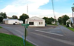
Intersection of Brunner Street and Horton Highway
|
|

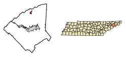
Location of Baileyton in Greene County, Tennessee.
|
|
| Country | United States |
| State | Tennessee |
| County | Greene |
| Incorporated | 1915 |
| Government | |
| • Type | Mayor/Aldermen |
| Area | |
| • Total | 1.62 sq mi (4.20 km2) |
| • Land | 1.62 sq mi (4.20 km2) |
| • Water | 0.00 sq mi (0.00 km2) |
| Elevation | 1,207 ft (368 m) |
| Population
(2020)
|
|
| • Total | 436 |
| • Density | 268.80/sq mi (103.80/km2) |
| Time zone | UTC-5 (Eastern (EST)) |
| • Summer (DST) | UTC-4 (EDT) |
| ZIP code |
37745
|
| Area code(s) | 423 |
| FIPS code | 47-02780 |
| GNIS feature ID | 2405199 |
Baileyton is a small town located in the northern part of Greene County, Tennessee, in the United States. In 2020, about 436 people lived there. It's about 13 miles north of Greeneville and 18 miles southeast of Rogersville.
Contents
History of Baileyton
The area where Baileyton is now was first settled way back in 1776. It was originally called "Laurel Gap." Many families, mostly farmers, lived there.
Later, the name changed to "Bailey Town" in 1892. This name was used until 1915. In 1915, the town officially became a city, or "incorporated." At that time, the "w" was dropped from "Bailey Town," and it became "Baileyton." The town was named after two brothers, Claudius and Thomas P. Bailey, who lived there.
Geography of Baileyton
Baileyton is located at the bottom of a rugged area in northern Greene County. It is just south of the Hawkins County border. A large mountain called Bays Mountain is to the north. It is part of the Ridge-and-Valley Appalachians mountain range.
Small streams like Gardner Creek and Hughes Branch flow through the town. These streams eventually join Lick Creek, which then flows into the Nolichucky River.
The United States Census Bureau says that Baileyton covers a total area of about 4.3 square kilometers (1.62 square miles). All of this area is land, with no water.
People of Baileyton
The number of people living in Baileyton has changed over the years. Here's how the population has grown and shrunk:
| Historical population | |||
|---|---|---|---|
| Census | Pop. | %± | |
| 1920 | 169 | — | |
| 1930 | 212 | 25.4% | |
| 1940 | 229 | 8.0% | |
| 1950 | 224 | −2.2% | |
| 1960 | 206 | −8.0% | |
| 1970 | 258 | 25.2% | |
| 1980 | 333 | 29.1% | |
| 1990 | 309 | −7.2% | |
| 2000 | 504 | 63.1% | |
| 2010 | 431 | −14.5% | |
| 2020 | 436 | 1.2% | |
| Sources: | |||
In 2020, the 2020 United States census counted 436 people living in Baileyton. There were 193 households and 105 families in the town at that time.
Mail Service
Baileyton does not have its own post office. The closest post office is in Greeneville. Baileyton shares the ZIP code 37745 with Greeneville and Tusculum.
Schools in Baileyton
Schools in Baileyton are managed by the Greene County Schools system.
- Baileyton Elementary School teaches students from pre-kindergarten to 4th grade.
- North Greene High School serves students in grades 9 through 12.
North Greene Middle School is located in nearby Ottway. It used to be called Ottway Elementary. This school now teaches students in grades 5 to 8.
Economy and Jobs
Most people who live in Baileyton work in Greeneville or other nearby cities. There are also some restaurants and gas stations near Interstate 81 exit 36. You can find several stores in Baileyton too.
Getting Around Baileyton
Baileyton is located right off Interstate 81 at exit 36. This is north of Greeneville.
- I-81 goes northeast about 42 miles to Bristol.
- It goes southwest about 70 miles to Knoxville (you connect to Interstate 40 there).
- State Route 172 connects Greeneville to Interstate 81 in Baileyton.
Van Hill Road used to be part of State Route 172. It connects to State Route 347. This road leads west to Rogersville and northeast to Kingsport.
Horton Highway is the main road that goes east and west through Baileyton. It connects Baileyton with Tennessee State Route 70 west of town near Romeo. It also connects to Tennessee State Route 93 east of Baileyton, north of Fall Branch.
See also
 In Spanish: Baileyton (Tennessee) para niños
 | Leon Lynch |
 | Milton P. Webster |
 | Ferdinand Smith |

