
Jefferson County, Tennessee facts for kids
Quick facts for kids
Jefferson County
|
|||
|---|---|---|---|

Jefferson County Courthouse in Dandridge
|
|||
|
|||

Location within the U.S. state of Tennessee
|
|||
 Tennessee's location within the U.S. |
|||
| Country | |||
| State | |||
| Founded | June 15, 1792 | ||
| Named for | Thomas Jefferson | ||
| Seat | Dandridge | ||
| Largest city | Jefferson City | ||
| Area | |||
| • Total | 314 sq mi (810 km2) | ||
| • Land | 274 sq mi (710 km2) | ||
| • Water | 40 sq mi (100 km2) 13%% | ||
| Population
(2020)
|
|||
| • Total | 54,683 | ||
| • Estimate
(2023)
|
57,838 |
||
| • Density | 174.15/sq mi (67.24/km2) | ||
| Time zone | UTC−5 (Eastern) | ||
| • Summer (DST) | UTC−4 (EDT) | ||
| ZIP Codes |
37725, 37760, 37820, 37871, 37877, 37890
|
||
| Area code | 865 | ||
| Congressional districts | 1st, 2nd | ||


Jefferson County is a county in the U.S. state of Tennessee. It has a mix of towns and open spaces. In 2020, about 54,683 people lived there. The main town, or county seat, is Dandridge. Jefferson County is part of a larger area called the Morristown Metropolitan Statistical Area. This area also includes Grainger and Hamblen counties. It's also connected to the even bigger Knoxville-Morristown-Sevierville Combined Statistical Area.
Contents
History of Jefferson County
How Jefferson County Was Formed
Jefferson County was officially started on June 11, 1792. It was created by William Blount, who was the governor of the Southwest Territory at that time. Before this, the area was part of Caswell County during a time when a short-lived state called the State of Franklin existed (from 1784 to 1789). The county seat, Dandridge, was settled even earlier, in 1783.
Jefferson County During the Civil War
Before the American Civil War began, most people in Jefferson County, like many in eastern Tennessee, did not want to leave the United States. On June 8, 1861, Tennessee voted on whether to separate from the U.S. Voters in Jefferson County said "no" to leaving by a large number: 1,987 against, and only 603 for.
During the war, a railroad bridge at Strawberry Plains was part of a plan to burn bridges in East Tennessee. This led to disagreements among people in the county. Some men from Jefferson County joined the Union Army, while others joined the Confederate Army.
A Sad Event on I-40
On October 2, 2013, a serious accident happened on I-40 in Jefferson County. It was near where I-40 and I-81 meet. A church bus, a large truck, and an SUV were involved. Officials found that a tire on the church bus blew out. This caused the bus to move into traffic coming the other way. It hit the SUV and then crashed into the semi-truck, which caught fire. Sadly, 8 people died and 14 were hurt in this accident.
How Jefferson County Voted for Presidents
Below is a list showing how people in Jefferson County voted in presidential elections over the years. You can see which political party received the most votes in each election.
| Year | Republican | Democratic | Third party | |||
|---|---|---|---|---|---|---|
| No. | % | No. | % | No. | % | |
| 2024 | 21,068 | 81.61% | 4,503 | 17.44% | 244 | 0.95% |
| 2020 | 18,651 | 78.98% | 4,654 | 19.71% | 311 | 1.32% |
| 2016 | 14,776 | 77.47% | 3,494 | 18.32% | 802 | 4.21% |
| 2012 | 13,038 | 74.25% | 4,232 | 24.10% | 289 | 1.65% |
| 2008 | 13,092 | 70.65% | 5,178 | 27.94% | 262 | 1.41% |
| 2004 | 11,625 | 67.53% | 5,469 | 31.77% | 121 | 0.70% |
| 2000 | 8,657 | 61.45% | 5,226 | 37.10% | 204 | 1.45% |
| 1996 | 6,446 | 53.03% | 4,688 | 38.57% | 1,021 | 8.40% |
| 1992 | 6,184 | 50.02% | 4,740 | 38.34% | 1,438 | 11.63% |
| 1988 | 6,832 | 67.85% | 3,168 | 31.46% | 69 | 0.69% |
| 1984 | 7,721 | 70.35% | 3,185 | 29.02% | 69 | 0.63% |
| 1980 | 6,944 | 66.82% | 3,180 | 30.60% | 268 | 2.58% |
| 1976 | 5,459 | 57.23% | 3,995 | 41.89% | 84 | 0.88% |
| 1972 | 5,925 | 80.26% | 1,357 | 18.38% | 100 | 1.35% |
| 1968 | 5,494 | 67.11% | 1,494 | 18.25% | 1,199 | 14.65% |
| 1964 | 4,923 | 65.44% | 2,600 | 34.56% | 0 | 0.00% |
| 1960 | 6,141 | 78.79% | 1,620 | 20.79% | 33 | 0.42% |
| 1956 | 4,870 | 77.63% | 1,338 | 21.33% | 65 | 1.04% |
| 1952 | 4,622 | 78.87% | 1,228 | 20.96% | 10 | 0.17% |
| 1948 | 2,979 | 74.12% | 900 | 22.39% | 140 | 3.48% |
| 1944 | 3,159 | 76.25% | 966 | 23.32% | 18 | 0.43% |
| 1940 | 1,921 | 63.95% | 1,062 | 35.35% | 21 | 0.70% |
| 1936 | 2,356 | 68.33% | 1,079 | 31.29% | 13 | 0.38% |
| 1932 | 2,275 | 68.59% | 975 | 29.39% | 67 | 2.02% |
| 1928 | 2,582 | 85.55% | 436 | 14.45% | 0 | 0.00% |
| 1924 | 2,699 | 78.39% | 712 | 20.68% | 32 | 0.93% |
| 1920 | 3,583 | 81.58% | 741 | 16.87% | 68 | 1.55% |
| 1916 | 1,648 | 75.84% | 520 | 23.93% | 5 | 0.23% |
| 1912 | 540 | 26.96% | 514 | 25.66% | 949 | 47.38% |
Geography and Nature
What Jefferson County Looks Like
Jefferson County covers about 314 square miles. Most of this (274 square miles) is land, and about 40 square miles (13%) is water. The county has two large artificial lakes. Douglas Lake is in the south, created by a dam on the French Broad River. Cherokee Lake is in the north, made by a dam on the Holston River.
Neighboring Counties
Jefferson County shares its borders with several other counties:
- Hamblen County (to the northeast)
- Cocke County (to the southeast)
- Sevier County (to the south)
- Knox County (to the west)
- Grainger County (to the north)
Protected Natural Areas
One special natural area in Jefferson County is the Henderson Island Refuge. This area helps protect wildlife and their homes.
Main Roads and Transportation
Many important roads run through Jefferson County, helping people travel and goods move around.
Major Highways
Other Important Routes
 SR 113
 SR 139
 SR 341
 SR 363
People and Population
How Many People Live Here?
The population of Jefferson County has grown a lot over the years. Here's how the number of people has changed:
| Historical population | |||
|---|---|---|---|
| Census | Pop. | %± | |
| 1810 | 7,309 | — | |
| 1820 | 8,953 | 22.5% | |
| 1830 | 11,801 | 31.8% | |
| 1840 | 12,076 | 2.3% | |
| 1850 | 13,204 | 9.3% | |
| 1860 | 16,043 | 21.5% | |
| 1870 | 19,476 | 21.4% | |
| 1880 | 15,846 | −18.6% | |
| 1890 | 16,478 | 4.0% | |
| 1900 | 18,590 | 12.8% | |
| 1910 | 17,755 | −4.5% | |
| 1920 | 17,677 | −0.4% | |
| 1930 | 17,914 | 1.3% | |
| 1940 | 18,621 | 3.9% | |
| 1950 | 19,667 | 5.6% | |
| 1960 | 21,493 | 9.3% | |
| 1970 | 24,940 | 16.0% | |
| 1980 | 31,284 | 25.4% | |
| 1990 | 33,016 | 5.5% | |
| 2000 | 44,294 | 34.2% | |
| 2010 | 51,407 | 16.1% | |
| 2020 | 54,683 | 6.4% | |
| 2023 (est.) | 57,838 | 12.5% | |
| U.S. Decennial Census 1790-1960 1900-1990 1990-2000 2010-2014 |
|||

Who Lives in Jefferson County?
The 2020 United States census counted 54,683 people living in Jefferson County. There were 20,154 households and 13,998 families. Here's a look at the different groups of people in the county:
| Group | Number of People | Percentage |
|---|---|---|
| White (not Hispanic or Latino) | 48,975 | 89.56% |
| Black or African American (not Hispanic or Latino) | 787 | 1.44% |
| Native American | 159 | 0.29% |
| Asian | 257 | 0.47% |
| Pacific Islander | 20 | 0.04% |
| Other/Mixed | 2,093 | 3.83% |
| Hispanic or Latino | 2,392 | 4.37% |
Economy and Jobs
Top Employers in the County
In 2023, the Tennessee Department of Economic and Community Development looked at the jobs in Jefferson County. Here are the top companies and organizations that employ the most people:
| # | Employer | # of Employees |
|---|---|---|
| 1 | Old Dominion Freight Line | 1,100 |
| 2 | Jefferson County Board of Education | 1,100 |
| 3 | Bush Brothers and Company | 500 |
| 4 | Nyrstar | 450 |
| 5 | Carson–Newman University | 404 |
| 6 | Oshkosh Corporation | 325 |
| 7 | Jefferson Memorial Hospital | 305 |
| 8 | Jefferson County Government | 300 |
| 9 | Walmart (Jefferson City) | 300 |
| 10 | Ball MetalPack | 159 |
Education
Schools in Jefferson County
Public schools for students from kindergarten through 12th grade in Jefferson County are managed by Jefferson County Public Schools.
Towns and Communities
Cities in Jefferson County
- Baneberry
- Jefferson City
- Morristown (part of this city is in Jefferson County, but most is in Hamblen County)
Towns in Jefferson County
- Dandridge (This is the county seat, where the main government offices are)
- New Market
- White Pine (A small part of this town is in Hamblen County)
Census-Designated Place
- Strawberry Plains (Parts of this area are also in Knox and Sevier counties)
Smaller Communities (Unincorporated)
These are smaller areas that are not officially cities or towns:
- Belmont
- Chestnut Hill
- Shady Grove
- Talbott (part of this community is also in another county)
Images for kids
-
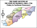
A map showing the counties of the State of Franklin, which existed before Tennessee became a state.

See also
 In Spanish: Condado de Jefferson (Tennessee) para niños
