Little Pigeon River (Tennessee) facts for kids
Quick facts for kids Little Pigeon River |
|
|---|---|

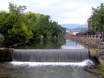
The mill dam of the Pigeon Forge Mill along the West Fork of the Little Pigeon River in Pigeon Forge, Tennessee.
|
|
| Country | United States |
| State | Tennessee |
| Physical characteristics | |
| Main source | Middle Prong Little Pigeon River below Mount Guyot in the Great Smoky Mountains National Park, Tennessee 3,028 ft (923 m) 35°41′35″N 83°19′12″W / 35.69306°N 83.32000°W |
| 2nd source | Porters Creek near Charlies Bunion in the Great Smoky Mountains National Park, Tennessee 4,680 ft (1,430 m) 35°38′50″N 83°21′47″W / 35.64722°N 83.36306°W |
| River mouth | French Broad River near Sevierville, Tennessee 860 ft (260 m) 35°55′51″N 83°35′43″W / 35.93083°N 83.59528°W |
| Length | 30 mi (48 km) |
| Basin features | |
| River system | Tennessee → Ohio → Mississippi |
| Basin size | 373 sq mi (970 km2) |
The Little Pigeon River is a river found entirely within Sevier County, Tennessee. It starts from many small streams that join together. These streams flow from the mountains between Tennessee and North Carolina. This area is inside the Great Smoky Mountains National Park.
The river has two main parts, called forks: the East Fork and the West Fork. The West Fork is even more divided into two smaller streams, known as prongs: the Middle Prong and the East Prong.
Contents
Discovering the Little Pigeon River
The Little Pigeon River is about 30 miles (48 km) long. It flows through Sevier County in Tennessee. This river is an important part of the local environment. It also helps support the towns along its banks.
Where the River Begins
The Little Pigeon River starts high up in the Great Smoky Mountains National Park. Its waters come from many small streams. These streams flow down from the mountains. The Middle Prong starts near a place called Greenbrier. The East Prong begins from streams in areas like Camp Hollow.
The River's Different Branches
The Little Pigeon River has two main branches, or "forks." These are the East Fork and the West Fork.
The East Fork's Journey
The East Fork is formed when the Middle Prong and the East Prong join together. The Middle Prong flows mostly alongside State Route 416. The East Prong starts outside the national park. It runs along State Road 339. A famous old bridge, the Harrisburg Covered Bridge, crosses the East Prong. These two prongs meet near the Walters State Community College campus.
The West Fork's Path
The West Fork is very well-known. This is because it flows through popular tourist towns. These towns include Gatlinburg and Pigeon Forge. Many visitors to these towns see the West Fork.
Where the Forks Meet and Beyond
The East Fork and West Fork of the Little Pigeon River meet in Sevierville. This meeting point is called "Forks of the River." From there, the river flows north. It runs next to State Route 66. Finally, the Little Pigeon River flows into the French Broad River. This happens downstream from Douglas Dam.
Not to Be Confused
Even though it's called the "Little Pigeon River," it's not a branch of the nearby Pigeon River. The Pigeon River also flows into the French Broad River. However, it joins the French Broad River much further upstream, above Douglas Dam.
 | Delilah Pierce |
 | Gordon Parks |
 | Augusta Savage |
 | Charles Ethan Porter |

