
Charlies Bunion facts for kids
Quick facts for kids Charlies Bunion |
|
|---|---|

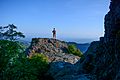
The characteristic boulder-like protrusion on northern face of Charlies Bunion, with the summit rising on the right
|
|
| Highest point | |
| Elevation | 5,528 ft (1,685 m) |
| Geography | |

Charlies Bunion
Location in Tennessee

Charlies Bunion
Location in the United States
|
|
| Location |
|
| Parent range | Great Smoky Mountains |
| Topo map | USGS Mount Guyot |
| Climbing | |
| Easiest route | Appalachian Trail from Newfound Gap |
Charlies Bunion is a cool mountain in the Great Smoky Mountains in the southeastern part of the United States. It's famous for a huge, rocky bump that sticks out near its top. This mountain is special because it's one of the few places in the Smokies where you can see bare rock at the very top.
Charlies Bunion is super tall, reaching 5,528 feet (about 1,685 meters) above sea level! It sits right on the border between Sevier County, Tennessee and Swain County, North Carolina. A famous hiking path called the Appalachian Trail goes right by its northern side. This makes it easy for hikers and even rock climbers to visit.
Contents
How Charlies Bunion Was Formed
Charlies Bunion is part of a jagged ridge called The Sawteeth. These cliffs connect the tall peaks in the middle of the Smokies with the tall peaks in the eastern part.
The rocks here are very old, formed almost a billion years ago. They started as mud and sand at the bottom of an ancient ocean. Over millions of years, these layers of rock were pushed up. This happened when the North American and African land plates slowly crashed into each other.
The northern side of Charlies Bunion is very steep. Water from this side flows into the Middle Fork of the Little Pigeon River. It drops about 2,000 feet (609 meters) in just over a mile! The southern side is not as steep. Water from there flows into the Oconaluftee River.
A Look Back in Time
Before the 1900s, not many people explored the Sawteeth area. It was a very wild and tough place. A writer named Horace Kephart once said you could barely travel seven miles a day there.
There was an old trail that went across the Smokies. It was called the Indian Gap Trail, and it's now part of U.S. Route 441. But some people used a different way. They would go up Kephart Prong to Dry Sluice Gap, which is near Charlies Bunion. Then they would go down into the Porters Creek Valley.
Around the year 1800, two brothers, William and Middleton Whaley, used this route. They were traveling between Oconaluftee and what is now Greenbrier.

The Big Fire and the Storm
Most of the central Smokies, including Charlies Bunion, used to be covered in thick forests. But in the early 1900s, large logging companies cut down many trees. This left huge piles of dry, dead branches and wood on the ground.
In 1925, a massive forest fire started. It fed on all the dry wood and quickly spread. The fire was so hot that it burned every plant in its path. It even made the soil unable to grow new plants.
Then, in 1929, a huge rainstorm hit the Smokies. The heavy rain washed away the burned soil from the western side of the Sawteeth. This is how Charlies Bunion got its rocky, bare look that we see today.

How Charlies Bunion Got Its Name
A few days after the big storm in 1929, a group of explorers went to see the damage. Horace Kephart, a famous writer and explorer, was leading them. When they reached the rocky, bare area, a mountain guide named Charlie Conner took off his shoe. His foot was very swollen, like a "bunion."
When Kephart saw Charlie's foot, he supposedly said, "I'm going to get this put on a Government map for you." And that's how the mountain got its unique name! The United States Geological Survey officially named it "Charlie's Bunion" soon after. The mountain next to it, Mount Kephart, was named after Horace Kephart himself.
In 1935, a group called the Civilian Conservation Corps built a part of the Appalachian Trail across Charlies Bunion. This was for the Great Smoky Mountains National Park, which had just opened. Today, the top of Charlies Bunion and its famous rock offer amazing views of Tennessee and other tall peaks in the Smokies, like Mount Le Conte.
Images for kids
-
It is hard to resist to climb Charlies Bunion, on the top of which people can enjoy the breeze from the valleys and the panoramic view of the Smokies.

