
Oconaluftee (Great Smoky Mountains) facts for kids
Quick facts for kids |
|
|
Oconaluftee Archeological District
|
|

View of the Oconaluftee River within the Great Smoky Mountains National Park
|
|

Location in North Carolina

Location in the United States
|
|
| Nearest city | Cherokee, North Carolina |
|---|---|
| Area | 383 acres (155 ha) |
| NRHP reference No. | 82001715 |
| Added to NRHP | February 19, 1982 |

The Oconaluftee is a beautiful valley in the Great Smoky Mountains of North Carolina. It's named after the Oconaluftee River that flows through it. This area was once home to a Cherokee village and later a community of early settlers. Today, it's the main entrance to Great Smoky Mountains National Park from North Carolina.
The Oconaluftee valley stretches from a place called Smokemont in the north to the southern end of the Qualla Boundary. The Qualla Boundary is a special area, often called Cherokee, North Carolina, which serves as a home for the Eastern Band of Cherokee Indians. The National Park Service manages parts of Oconaluftee. Here you can find the Oconaluftee Visitor Center, Mingus Mill, and the Mountain Farm Museum. A big part of this area is known as the Oconaluftee Archaeological District, recognized for its historical importance since 1982.
Contents
Welcome to Oconaluftee!
What is Oconaluftee?
Oconaluftee is a special place where history and nature meet. It's a valley carved by the Oconaluftee River, surrounded by the towering Great Smoky Mountains. This area has been important for hundreds of years, first for the Cherokee people and then for European settlers. Now, it's a gateway for visitors to explore one of America's most popular national parks.
Exploring the Land

Rivers and Mountains
High up in the mountains, near Newfound Gap, many small streams come together to form Beech Flats Prong. This stream flows south, dropping a lot of elevation before joining other streams like Kephart Prong and Kanati Fork. All these waters combine to create the Oconaluftee River. The river then carves a path through the valley, flowing between large mountain ranges.
Near the park's edge, the Oconaluftee River meets Raven Fork, creating a wide, flat area. After passing through the town of Cherokee, the river turns west. It eventually flows into the Tuckasegee River near Bryson City.
Ancient Rocks and Earth's History
The ground beneath Oconaluftee holds some of the oldest rocks in the eastern United States. These rocks are over a billion years old! They formed from ancient ocean mud and fiery volcanic rocks. Higher up in the valley, you'll find different rocks that are about 400 million years old. These rocks were pushed up when the North American and African continents slowly crashed into each other, forming the Appalachian Mountains. You can see these different rock layers along U.S. Route 441 as you drive between Newfound Gap and Cherokee.
A Look Back in Time: History

Early Cherokee Life
The Cherokee people believed the waters of the Oconaluftee were sacred and special. They had a legend about a deep part of the river called "Where the bears wash." It was said that all animals would go there to heal their wounds instantly. The name "Oconaluftee" comes from the Cherokee word Egwanulti, meaning "by the river."
Archaeologists have found evidence of a Cherokee village in Oconaluftee, right inside what is now the national park. This is the only known permanent Cherokee settlement within the park's boundaries. Sadly, this village was likely destroyed during the American Revolutionary War in 1776.
Settlers and Changes
The first European-American settler in the Oconaluftee valley was John Jacob Mingus, who arrived in the 1790s. His family stayed in the area for many years. Other families, like the Enloes and Bradleys, also settled here. Abraham Enloe, an early settler, was even thought by some to be the father of Abraham Lincoln because they looked alike!
In 1831, a road was built through the valley to reach saltpeter mines (saltpeter was used to make gunpowder). This road made it easier to travel through the mountains. A man named William Holland Thomas, who was adopted by a Cherokee chief, helped the Cherokee people buy land, including the Qualla Boundary. This land became a safe home for the Eastern Band of the Cherokee. During a difficult time when many Cherokee were forced to leave their homes, Thomas successfully argued that the Oconaluftee Cherokees, as North Carolina citizens, should be allowed to stay.
The Park is Born
In the late 1800s, new tools and logging trains led to a big logging industry in the mountains. Companies cut down many trees in the Oconaluftee valley. In the 1930s, the land was bought to create the Great Smoky Mountains National Park. After the park was established, a group called the Civilian Conservation Corps (CCC) helped build roads and trails. In 1937, the CCC restored Mingus Mill, an old water-powered mill. Later, in the 1950s, several old log buildings were moved to the Oconaluftee Visitor Center area to create the Mountain Farm Museum. This museum shows what pioneer life was like for early settlers.
Today at Oconaluftee


Today, Oconaluftee is a popular place for visitors. Besides the historic sites near the Visitor Center, there's a large campground at Smokemont. The southern end of the Blue Ridge Parkway, a famous scenic road, also starts here. You can hike on trails like the Mountains-to-Sea Trail or the Bradley Fork Trail, which lead to amazing views and other parts of the park. In 1982, the Oconaluftee area was officially recognized as an important archaeological district.
Mingus Mill: A Working History


Mingus Mill was built in 1886 by Sion Thomas Early for John Mingus. It cost $600 and took three months to build. The mill used to grind grain for people in the valley. The National Park Service bought it in 1934 and restored it in 1937. It closed during World War II but reopened in 1968.
The mill works by using water from Mingus Creek. The water flows through a channel and turns two special water wheels called turbines. These turbines power the grindstones that turn wheat or corn into flour or cornmeal. The mill also has machines to clean the grain and separate the flour into different types. The turbines were very efficient and needed less water than other types of water wheels. A man named Aden Carver, who helped build the mill in 1886, also helped restore it when he was in his 90s! You can also find signs at the mill that talk about how jazz artist Charles Mingus's family connects to this area.
The Oconaluftee Visitor Center
The first visitor center at Oconaluftee was built in 1940 as a ranger station. It became a "temporary" visitor center in 1947 and stayed that way for a long time! In 2011, a brand new visitor center was built. It was paid for by donations, not government money. The new center and restrooms are open all year. The old building is now used for park offices, but its rustic look remains the same.
Mountain Farm Museum: Step Back in Time
Next to the Oconaluftee Visitor Center is the Mountain Farm Museum. This outdoor museum has several old log buildings that were moved from different parts of the park. It shows what a typical mountain farm looked like for pioneer families in the Appalachian region. Gardens are planted in spring and summer, and farm animals roam around.
Some of the buildings you can see include:
- The John Davis Cabin, built in 1900. It was moved from Indian Creek.
- The Enloe Barn, built around 1880. This is the only building that originally stood in Oconaluftee, moved only a short distance. It has over 16,000 hand-split roof shingles!
- The Messer Applehouse, used to store apples. It was partly underground to keep apples cool in summer and warm in winter.
- A meathouse, used to smoke and cure meat, usually pork.
- A chickenhouse, to protect chickens from wild animals.
- A blacksmith shop, where tools and metal items were made.
- A springhouse, used like a refrigerator to keep food cool.
- Two corn cribs, where corn was stored after harvest.
You can also see a hog pen, a sorghum press (for making syrup), an ash hopper (for making soap), a woodshed, and old-style fences.
Oconaluftee Indian Village
The Oconaluftee Indian Village is a living history museum run by the Cherokee Historical Association. It's a copy of a typical Cherokee village from the mid-1700s. Here, you can learn about Cherokee culture and traditions from that time.
Images for kids
-
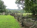
19th century fence at Mountain Farm Museum
-
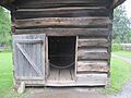
Meat storage house, used mostly for pork, at the Mountain Farm Museum


See also
 In Spanish: Oconaluftee para niños
