Oconaluftee River facts for kids
Quick facts for kids Oconaluftee River |
|
|---|---|

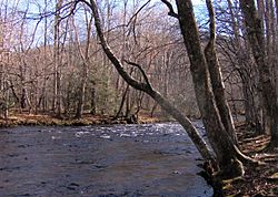
View of the Oconaluftee River within the Great Smoky Mountains National Park
|
|
| Native name | Ocona Luftee; Oconalufty |
| Other name(s) | Egwanulti |
| Country | United States |
| State | North Carolina |
| Physical characteristics | |
| Main source | Beech Flats Prong |
| River mouth | Tuckasegee River 35°58′7″N 83°36′15″W / 35.96861°N 83.60417°W |
| Length | 30 mi (48 km) |
| Basin features | |
| River system | Tuckasegee → Little Tennessee → Tennessee → Ohio → Mississippi |
The Oconaluftee River flows through the beautiful Great Smoky Mountains in Western North Carolina. It eventually joins the Tuckasegee River. This river is very important because it runs through the Qualla Boundary. This land is a special federal trust that serves as a home for the Eastern Band of the Cherokee. They are the only Cherokee tribe officially recognized by the US government in North Carolina.
The Cherokee people bought this land back in the 1870s. This happened after they were forced to leave their homes earlier in the 1800s. Many old Cherokee towns were once located along this important river.
Contents
Where Does the Oconaluftee River Start?
The Oconaluftee River begins as a stream called Beech Flats Prong. This stream forms from several springs high in the Appalachian Mountains. These springs are near Newfound Gap, a mountain pass in the middle of the Great Smoky Mountains National Park. This pass is right on the border between Tennessee and North Carolina.
The Beech Flats Prong flows south for about 10 miles (16 km). It then meets other streams like Smith Branch and Kanati Fork. These streams all come together to form the Oconaluftee River. As the river continues south, it gets even bigger when the Bradley Fork joins it.
How the River Shapes the Land
The river helps create a large, flat area of land called a bottomland. This happens where the Oconaluftee River meets the Raven Fork near Cherokee. At this point, the river turns west. It then flows until it reaches its mouth on the Tuckasegee River.
The town of Bryson City in Swain County, North Carolina grew up near where these rivers meet. The Oconaluftee River also flows through several other communities. These include Smokemount, the Oconaluftee Village, and the towns of Cherokee, Indian Hills, and Birdtown.
A River with a Rich History
For thousands of years, Native American people lived in this region. They usually built their homes close to rivers and other waterways. The historic Cherokee people lived here long before Europeans arrived. They considered the waters of the Ocona Luftee to be sacred and very special.
The name "Ocona Luftee" comes from a Cherokee village called Egwanulti. This village was built on the riverbanks before European settlers came to the area. The name "Egwanulti" means "by the river" in English. The Cherokee people named both the river and the village.
Cherokee People Stay in Their Homeland
In the 1830s, many Native American tribes were forced to move from the Southeast. This event is known as the Indian removal. However, some Cherokee people were given a chance to stay. They could buy plots of land for their families if they agreed to leave their tribe. If they did this, they became US citizens and were not forced to move.
About 500 Cherokee people, led by a man named Yonaguska, lived on land along the Oconaluftee River. This land was owned by William Holland Thomas, a white man who held it in trust for the Cherokee. This meant he legally protected the land for them. Thomas had been adopted by the Cherokee when he was a boy. He helped this group of Cherokee stay safe from being removed from their homes.
A smaller group of about 150 people also joined them. These people lived along the Nantahala River and were led by Utsala. Other Cherokee groups living in Snowbird and along the Cheoah River also stayed in the region. If they needed to, all these groups could gather on the land protected by Thomas. Today, their descendants make up most of the Eastern Band of Cherokee Indians. In the 1870s, the Cherokee people bought more land in North Carolina, which became the Qualla Boundary.
 | Jewel Prestage |
 | Ella Baker |
 | Fannie Lou Hamer |


