
Mount Kephart facts for kids
Quick facts for kids Mount Kephart |
|
|---|---|

Mt. Kephart, looking west from Charlies Bunion
|
|
| Highest point | |
| Elevation | 6,217 ft (1,895 m) |
| Prominence | 660 ft (200 m) |
| Geography | |
| Location | Sevier County, Tennessee / Swain County, North Carolina, U.S. |
| Parent range | Great Smoky Mountains |
| Topo map | USGS Mount Le Conte |
| Climbing | |
| Easiest route | Appalachian Trail + Boulevard Trail + Jumpoff Trail |
Mount Kephart is a tall mountain located in the middle of the Great Smoky Mountains in the southeastern United States. It's a popular spot for hikers, especially those walking the long Appalachian Trail, which crosses its southern side.
One amazing feature is The Jumpoff, a huge cliff about 1,000 feet (300 meters) high on the mountain's northeast side. From here, you can see incredible views of the central and eastern parts of the Smokies. The higher parts of Mount Kephart are covered with a special type of forest called a spruce-fir forest.
Mount Kephart is the 22nd tallest mountain in the eastern U.S. and the 7th tallest in Tennessee. However, it doesn't stand out as much as it could because it's very close to two even taller mountains: Clingmans Dome and Mount Le Conte.
Like many peaks in the Smokies, Mount Kephart sits right on the border between Tennessee and North Carolina. It's located in Sevier County, Tennessee and Swain County, North Carolina. The mountain rises almost 4,000 feet (1,200 meters) from its northern base and about 3,400 feet (1,000 meters) from its southern base. Newfound Gap, a mountain pass over 5,000 feet (1,500 meters) high, separates Mount Kephart from another peak called Fork Ridge to the west. U.S. Highway 441, the only paved road that crosses the Great Smoky Mountains National Park from north to south, goes through Newfound Gap.
Contents
How Was Mount Kephart Formed?
The Rocks of Mount Kephart
Mount Kephart is made of a type of rock called Anakeesta Formation. This rock is a mix of slate and metasiltstone. You can see this kind of rock clearly at Charlies Bunion, which is just northeast of Mount Kephart.
These Anakeesta Formation rocks are part of a much larger group called the Ocoee Supergroup. They were formed from ocean sediments almost a billion years ago!
When the Mountain Rose
The mountain itself was created about 200 million years ago. This happened when the African and North American land plates slowly crashed into each other. This huge collision pushed the rocks upward, forming the Appalachian Mountains.
The Story Behind Mount Kephart's Name
Who Was Horace Kephart?
Mount Kephart is named after Horace Kephart. He was an important writer and one of the first people to suggest creating a national park in the Smokies.
How the Name Changed
Before 1931, this mountain was actually called "Mount Collins." But then, the USGS (a government agency that maps the land) gave it its current name, Mount Kephart. The name "Mount Collins" was then moved to a different peak between Clingmans Dome and Newfound Gap. Before the 1880s, Mount Kephart was known by many different local names.
Early Explorers and Measurements
Arnold Henry Guyot, an early explorer, likely visited and measured Mount Kephart in the late 1850s. However, it's not clear what name he used for the mountain. He recorded two mountains in this area as being over 6,000 feet (1,800 meters) tall.
Laura Thornborough, a writer who explored the Smokies in the 1930s, wrote about a cool spring on Mount Kephart's south side. She said, "Our party reached a good spring on the Carolina side of Mt. Kephart... The water was clear and icy cold." This spring is now known as Icewater Spring.
Historic Camps and Projects
In the 1930s, a CCC camp was located at the southern base of the mountain. The chimney from this camp can still be seen near the start of the Kephart Prong Trail. During World War II, this camp was used to house people who refused to fight in the war for moral reasons. Also in this area are the remains of a fish hatchery built in 1936 by the WPA.
Exploring Mount Kephart: Trails and Views
The Appalachian Trail
The famous Appalachian Trail crosses the southern slope of Mount Kephart. While the trail doesn't go right over the very top of the mountain, there are several open areas with great views. These spots, between Mount Ambler and Icewater Spring, offer sights of the south-central Smokies and Clingmans Dome. There's even a special shelter at Icewater Spring for hikers on the Appalachian Trail to rest.
The Jumpoff Trail
The Jumpoff Trail goes over the summit of Mount Kephart and leads to The Jumpoff. This is a high cliff on the mountain's northern side. From The Jumpoff, you can usually see more than 180 degrees of amazing scenery, from Mount Le Conte to the northwest all the way to the Balsam Mountains in the southeast. The Jumpoff Trail is just a short distance from where the Appalachian Trail and Boulevard Trail meet, about three miles (5 km) from Newfound Gap.
The Kephart Prong Trail
The Kephart Prong Trail climbs up the mountain's south slope to the Kephart Backcountry Shelter. You can find the start of this trail on U.S. Highway 441, between Newfound Gap and the Oconaluftee Valley. After about two miles (3 km), the Kephart Prong Trail splits. One path, the Sweat Heifer Trail, goes to Kephart's southwest slope. The other path continues to Dry Sluice Gap, near Charlies Bunion.
Images for kids
-
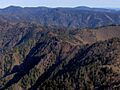
Jagged, V-shaped ridges show the history of the Smokies, looking east from The Jumpoff
-
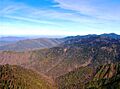
Looking northeast from The Jumpoff, with characteristic blue haze on the left
-
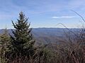
Looking southeast from the summit of Mt. Kephart


