
Mount Le Conte (Tennessee) facts for kids
Quick facts for kids Mount Le Conte |
|
|---|---|

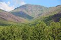
Mount LeConte from the Carlos Campbell Overlook
|
|
| Highest point | |
| Elevation | 6,593 ft (2,010 m) |
| Prominence | 1,360 ft (410 m) |
| Geography | |
| Location | Sevier County, Tennessee |
| Parent range | Appalachian Mountains, Blue Ridge Mountains, Great Smoky Mountains |
| Topo map | USGS Mount Le Conte |
| Climbing | |
| First ascent | unknown |
| Easiest route | Hike |
Mount Le Conte is a tall mountain located in the Great Smoky Mountains National Park in Sevier County, Tennessee. It stands at 6,593 feet (2,010 meters) high. This makes it the third highest peak in the national park. Only Clingmans Dome (6,643 feet) and Mount Guyot (6,621 feet) are taller.
Mount Le Conte is special because it's the highest mountain completely inside Tennessee. From its base near Gatlinburg, Tennessee, it rises an amazing 5,301 feet (1,616 meters). This makes it one of the tallest peaks in the entire Appalachian Mountains when measured from its bottom to its top.
The mountain has four main peaks that are all over 6,000 feet tall. These are West Point (6,344 feet), High Top (6,593 feet), Cliff Tops (6,555 feet), and Myrtle Point (6,200 feet). Mount Le Conte is also famous for having the highest inn (a type of hotel) in the eastern United States, where visitors can stay overnight.
Contents
Exploring Mount Le Conte's Past
There's a bit of a mystery about who Mount Le Conte was named after! The United States Geological Survey says it was named for Joseph LeConte, a famous geologist. They believe a Swiss explorer named Arnold Henry Guyot gave it the name.
However, some local experts think it was named after Joseph's older brother, John Le Conte. John was a physicist. They say a man named Samuel Buckley named the mountain to thank John for helping him move his barometer (a weather tool) to Waynesville, North Carolina.
Even though the mountain was measured in the 1850s, not much happened there until the 1920s. That's when Paul Adams, a keen hiker, moved to Knoxville, Tennessee. He loved exploring the mountains.
In 1924, Paul Adams joined a group working to make the region a national park. To show how beautiful the mountains were, he led an important trip up Mount Le Conte. People from Washington, D.C., joined him. They spent the night in a large tent, which later became a cabin. This cabin eventually grew into the LeConte Lodge, a popular place to stay near the top of the mountain. The trip was a big success! About ten years later, Mount Le Conte and the surrounding area became part of the Great Smoky Mountains National Park.
How Mount Le Conte Was Formed
Mount Le Conte is part of the Appalachian Mountains and the Blue Ridge Mountains. It's made of very old rocks, some formed over 800 million years ago! These rocks include sandstone, siltstone, shale, and conglomerate.
Over millions of years, weather has slowly worn down the mountain. This erosion has given Mount Le Conte and other mountains in the area their gentle, sloping shape. The upper parts of the mountain are covered in a thick forest of spruce and fir trees. These trees are a leftover from the last Ice Age!
Weather on the Mountain
Mount Le Conte has a cool climate because it's so high up. It has cool summers and cold, snowy winters. This type of climate is called a humid continental climate, and it's almost like a subalpine climate.
The mountain gets a lot of snow. Near the bottom, it averages about 40 inches of snow each year. But on the highest peak, it can get up to 80 inches! The weather is much cooler and a bit wetter than in the lower areas. The coldest temperature ever recorded was -32 °F (-35.6 °C) on January 13, 1986. The warmest was 82 °F (27.8 °C) on July 1, 2012.
| Climate data for Mount LeConte | |||||||||||||
|---|---|---|---|---|---|---|---|---|---|---|---|---|---|
| Month | Jan | Feb | Mar | Apr | May | Jun | Jul | Aug | Sep | Oct | Nov | Dec | Year |
| Record high °F (°C) | 60 (16) |
60 (16) |
66 (19) |
71 (22) |
79 (26) |
81 (27) |
82 (28) |
79 (26) |
77 (25) |
74 (23) |
68 (20) |
61 (16) |
82 (28) |
| Mean daily maximum °F (°C) | 34.3 (1.3) |
36.5 (2.5) |
42.1 (5.6) |
50.2 (10.1) |
56.9 (13.8) |
63.2 (17.3) |
65.9 (18.8) |
65.5 (18.6) |
61.1 (16.2) |
54.0 (12.2) |
45.1 (7.3) |
36.9 (2.7) |
51.0 (10.5) |
| Daily mean °F (°C) | 25.8 (−3.4) |
27.7 (−2.4) |
32.8 (0.4) |
40.4 (4.7) |
48.3 (9.1) |
54.8 (12.7) |
57.7 (14.3) |
57.0 (13.9) |
52.1 (11.2) |
44.6 (7.0) |
36.4 (2.4) |
28.2 (−2.1) |
42.2 (5.7) |
| Mean daily minimum °F (°C) | 17.3 (−8.2) |
19.0 (−7.2) |
23.4 (−4.8) |
30.5 (−0.8) |
39.6 (4.2) |
46.5 (8.1) |
49.6 (9.8) |
48.6 (9.2) |
43.2 (6.2) |
35.2 (1.8) |
27.7 (−2.4) |
19.4 (−7.0) |
33.3 (0.7) |
| Record low °F (°C) | −32 (−36) |
−23 (−31) |
−11 (−24) |
1 (−17) |
12 (−11) |
28 (−2) |
30 (−1) |
30 (−1) |
19 (−7) |
10 (−12) |
−2 (−19) |
−15 (−26) |
−32 (−36) |
| Average precipitation inches (mm) | 6.14 (156) |
5.42 (138) |
6.11 (155) |
6.37 (162) |
7.18 (182) |
7.30 (185) |
6.81 (173) |
6.48 (165) |
5.72 (145) |
3.72 (94) |
6.39 (162) |
5.85 (149) |
73.49 (1,866) |
| Average snowfall inches (cm) | 14.8 (38) |
18.6 (47) |
15.6 (40) |
6.1 (15) |
1.1 (2.8) |
0.0 (0.0) |
0.0 (0.0) |
0.0 (0.0) |
0.0 (0.0) |
2.1 (5.3) |
5.9 (15) |
15.6 (40) |
79.8 (203.1) |
Staying at LeConte Lodge

Mount Le Conte is special because it has the highest inn (a place to stay) in the eastern United States. This is the LeConte Lodge, which opened in 1925. It started as a tent, then became a single cabin, and now it's a group of small log cabins and a main dining hall.
The lodge can host about 50 guests each night. It's usually open from March to November. You can't drive to the lodge; all guests must hike there! Supplies are brought in by helicopter and even by llama pack trains. The weather at the lodge is similar to southern Canada, with cool summers and cold, snowy winters. The National Park Service helps maintain the lodge.
Hiking Trails to the Top

Since Mount Le Conte is in the Great Smoky Mountains National Park, there are five different trails that lead to the LeConte Lodge. There are also smaller trails that go to each of the mountain's individual peaks. Each trail has its own beautiful sights and unique features along the way.
Here are the trails and their one-way distances:
- Alum Cave Trail — 4.9 miles (7.9 km). This trail has cool spots like Alum Cave Creek, Arch Rock, and Alum Cave Bluff. It's known for being very scenic and is often the most used trail.
- The Boulevard Trail — 5.4 miles (8.7 km) or 8.0 miles (12.9 km) from Newfound Gap. This trail stays high up, never dropping below 5,500 feet (1,676 meters).
- Bullhead Trail — 6.9 miles (11.1 km). This is the quietest trail, so it's great if you want to hike alone.
- Rainbow Falls Trail — 6.6 miles (10.6 km). LeConte Creek runs next to this trail. You'll see Rainbow Falls, which is the tallest waterfall in the national park.
- Trillium Gap Trail — 8.9 miles (14.3 km). On this trail, you can walk behind Grotto Falls, which is the only waterfall in the park where you can do that! This trail is also used by the llama trains that bring supplies to the lodge. If you start at the Trillium Gap parking lot, the hike is shorter, only 6.5 miles (10.5 km).
Because so many people use these five trails, Mount Le Conte is one of the most hiked mountains in the park. The Alum Cave and Rainbow Falls trails are especially popular. Hikers can also stay overnight in a special shelter for a small fee, but you need a permit and reservation from the National Park Service.
In 2016, the area around Mount Le Conte was affected by wildfires. The park had to be evacuated during this time to keep everyone safe.
Images for kids
-
Mount LeConte from the Carlos Campbell Overlook
-
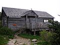
The office of the LeConte Lodge
-
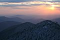
View from Cliff Tops atop Mount LeConte
