Alum Cave Trail facts for kids
Quick facts for kids Alum Cave Trail |
|
|---|---|

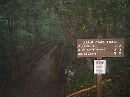
The trailhead of the Alum Cave Trail
|
|
| Length | 5.0 mi (8.0 km) |
| Location | Great Smoky Mountains National Park, Tennessee, United States |
| Trailheads | Mount Le Conte, Tennessee (Trailhead near Walker Camp Prong off U.S. Highway 441) Terminus at junction with the Rainbow Falls Trail near the LeConte Lodge |
| Use | Hiking |
| Elevation change | 2,700 ft (820 m) |
| Highest point | Junction with the Rainbow Falls Trail |
| Lowest point | Trailhead at Walker Camp Prong |
| Difficulty | Moderately strenuous |
| Season | Spring to Fall |
| Sights | Arch Rock, Alum Cave Bluff, Great Smoky Mountains |
| Hazards | Ice (in winter), loose rocks |
The Alum Cave Trail is a super popular hiking trail in the Great Smoky Mountains National Park in Tennessee, USA. It's known for its amazing views and interesting rock formations. This trail climbs up Mount Le Conte, which is one of the tallest mountains east of the Mississippi River. Along the way, you'll see cool spots like Arch Rock and the famous Alum Cave Bluff. The trail eventually joins up with the Rainbow Falls Trail close to the mountain's top.
Contents
Discovering the Alum Cave Trail
The Alum Cave Trail is the shortest way to reach the top of Mount Le Conte. It's also the steepest! Many hikers choose this path because it's so beautiful. The trail is about 5 miles (8 kilometers) long, and it takes you through some incredible scenery.
The trail starts about 10 miles (16 kilometers) from Gatlinburg, Tennessee. You can find the trailhead right off U.S. Highway 441, also known as Newfound Gap Road.
Starting Your Hike: Trailhead to Arch Rock
Your adventure on the Alum Cave Trail begins at an elevation of about 3,834 feet (1,169 meters). Right away, you'll cross two streams: Walker Camp Prong and Alum Cave Creek. Alum Cave Creek will be your companion for the first 1.3 miles (2.1 kilometers) of the hike.
This first part of the trail is pretty easy. You'll walk through an old forest filled with tall hemlock and yellow birch trees. The path is well-kept because so many people use it.
After about 1.3 miles (2.1 kilometers), you'll reach the first cool landmark: Arch Rock. This is a huge, dark rock that has formed a natural arch over thousands of years. You can easily walk through it using stairs and steel cables that act as handrails. It's a neat experience!
Exploring Beyond Arch Rock: Alum Cave Bluff
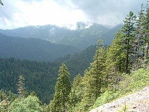
As you hike past Arch Rock, you'll notice the sound of Alum Cave Creek fading away. A smaller stream called Styx Branch will then join your path for a short distance. The next exciting spot is Inspiration Point. This rocky lookout is about 4,700 feet (1,433 meters) high. On a clear day, you can see amazing views of the mountains around you, especially Little Duck Hawk Ridge.
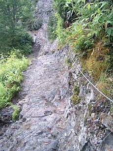
Not far from Inspiration Point, look to your left for the Eye of the Needle. This is a round, see-through hole in the side of Little Duck Hawk Ridge. The trail gets rockier here, but it's still a popular section.
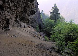
After about 2.2 miles (3.5 kilometers) from the start, you'll reach the famous Alum Cave Bluff. This bluff is about 4,950 feet (1,509 meters) high and 80 feet (24 meters) tall. Its orange clay color makes it stand out! For many hikers, this bluff is their final destination. In winter, huge icicles can form here, making it a bit dangerous. But in other seasons, it's a great place to shelter from rainstorms.
Reaching the Top: Alum Cave Bluff to LeConte Lodge
This last section of the trail is more than half of the total distance. Most of the crowds will be gone, leaving only hikers determined to reach the top of Mount Le Conte. The first half-mile after the bluff is the steepest part of the entire hike.
In this section, you'll find Gracie's Pulpit. This spot is named after Gracie McNichol, a famous hiker who walked this trail on her 92nd birthday! Gracie's Pulpit marks the halfway point of the Alum Cave Bluff Trail. From here, you can get a clear view of all four peaks of Le Conte: West Point, Cliff Tops, High Top, and Myrtle Point.
After Gracie's Pulpit, the trail becomes a peaceful and scenic walk through the highlands. You'll cross small streams and find more overlooks. Once you reach the 6,000-foot (1,829-meter) plateau, you'll see many dead trees. These were once beautiful Fraser firs, but they were harmed by tiny insects called balsam woolly adelgids and acid rain. However, lots of healthy young Fraser firs are now growing, giving hope for the future of these trees.
The trail ends when it merges with the Rainbow Falls Trail at the LeConte Lodge. This lodge is the only place to stay overnight in the national park. It has simple cabins with no electricity. For many, reaching the lodge is the end of their journey. But the actual peaks of Le Conte are just a short walk away from the lodge. Cliff Tops and Myrtle Point offer amazing panoramic views of the mountains and valleys below.
Maps and Directions
You can find the Alum Cave Trail on the Mount Le Conte 1:24,000-scale topographic map. This map is published by the National Park Service.
 | Sharif Bey |
 | Hale Woodruff |
 | Richmond Barthé |
 | Purvis Young |


