
Waynesville, North Carolina facts for kids
Quick facts for kids
Waynesville, North Carolina
|
|||
|---|---|---|---|

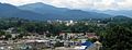
Waynesville skyline
|
|||
|
|||
| Motto(s):
"Progress with Vision"
|
|||

Location in North Carolina
|
|||
| Country | United States | ||
| State | North Carolina | ||
| County | Haywood | ||
| Incorporated | 1810 | ||
| Area | |||
| • Total | 8.94 sq mi (23.14 km2) | ||
| • Land | 8.94 sq mi (23.14 km2) | ||
| • Water | 0.00 sq mi (0.00 km2) 0% | ||
| Elevation | 2,697 ft (822 m) | ||
| Population
(2020)
|
|||
| • Total | 10,140 | ||
| • Density | 1,134.74/sq mi (438.11/km2) | ||
| Time zone | UTC−5 (Eastern) | ||
| • Summer (DST) | UTC−4 (EDT) | ||
| ZIP codes |
28738, 28785, 28786
|
||
| Area code(s) | 828 | ||
| FIPS code | 37-71500 | ||
| GNIS feature ID | 2406845 | ||


Waynesville is a town in North Carolina, United States. It is the main town in Haywood County. Waynesville is the biggest town in western North Carolina, located southwest of Asheville. It sits between the beautiful Great Smoky Mountains and Blue Ridge Mountains.
In 2020, about 10,140 people lived in Waynesville. The town is very close to the Pisgah National Forest and the Great Smoky Mountains National Park. It is also near the famous Blue Ridge Parkway, a scenic road. Waynesville is part of a larger group of towns around Asheville, making it an important area in North Carolina.
Contents
History of Waynesville
Waynesville was started in 1810 by Colonel Robert Love. He was a soldier in the American Revolutionary War. Colonel Love gave land for the town's courthouse, jail, and public square. He named the town after his old commander, General "Mad" Anthony Wayne.
The town officially became a town in 1871. Later, in July 1995, Waynesville joined with another nearby town called Hazelwood. This made the community bigger, and it has continued to grow.
The Last Shot of the Civil War
Waynesville was the site of a very interesting event during the American Civil War. On May 6, 1865, Union soldiers were attacked near Waynesville. This attack came from a group of Confederate soldiers known as Thomas' Legion of Highlanders.
These soldiers were a mix of Cherokee and White fighters. They had been fighting in other parts of the war. They were sent back to the mountains of North Carolina to continue fighting.
The Union soldiers went back into Waynesville. On the night of May 6, Thomas' Legion surrounded the town. They lit many campfires on the hills above. They also made loud war chants to scare the Union soldiers.
The next day, the Confederate leaders, General James Green Martin and Colonel William Holland Thomas, met with the Union side. They decided to surrender. They had learned that the main Confederate armies had already given up. Continuing to fight would not have helped. This event is sometimes called "The Last Shot" of the Civil War in the eastern United States.
Frog Level: A Historic Area

Waynesville started to grow a lot after the railroad arrived in 1884. The railroad helped businesses like farming, lumber, and tourism. It made it easier to move goods and people.
The area near Richland Creek, below Main Street, is where the railroad tracks were built. This area used to be a swamp. When the train depot was built, this section developed quickly. People called it "Frog Level" because it was low-lying and often flooded, like where frogs live.
Frog Level and downtown Waynesville were the main places for shopping and social life until the 1940s. Businesses in Frog Level depended on the railroad. They included hardware stores, farm supply shops, and lumber companies.
As cars became more common, the railroad became less important. Businesses started to move away from Frog Level. The last passenger train came to Waynesville in 1949. Freight trains still pass through Frog Level twice a day.
The first train depot burned down in 1900. A new one was built, which stayed until 1987. Today, the Frog Level Historic District is a special place listed on the National Register of Historic Places. There is a spring festival there each year that celebrates nature.
Geography and Climate
Waynesville is in the middle of Haywood County. It is in the valley of Richland Creek, which flows into the Pigeon River. The town covers about 23.1 square kilometers (8.9 square miles) of land.
Waynesville's Weather
Waynesville has a mild climate because it is located high up in the mountains. It has warm summers and cool winters. The weather is called a "subtropical highland climate."
| Climate data for Waynesville, North Carolina, 2,658 ft (810 m) amsl (1991−2020 normals, extremes 1894−present) | |||||||||||||
|---|---|---|---|---|---|---|---|---|---|---|---|---|---|
| Month | Jan | Feb | Mar | Apr | May | Jun | Jul | Aug | Sep | Oct | Nov | Dec | Year |
| Record high °F (°C) | 78 (26) |
79 (26) |
89 (32) |
89 (32) |
92 (33) |
98 (37) |
98 (37) |
96 (36) |
92 (33) |
90 (32) |
83 (28) |
78 (26) |
98 (37) |
| Mean daily maximum °F (°C) | 46.6 (8.1) |
50.2 (10.1) |
56.7 (13.7) |
65.6 (18.7) |
72.8 (22.7) |
78.5 (25.8) |
81.5 (27.5) |
80.5 (26.9) |
75.6 (24.2) |
67.1 (19.5) |
57.5 (14.2) |
49.9 (9.9) |
65.2 (18.4) |
| Daily mean °F (°C) | 35.0 (1.7) |
38.2 (3.4) |
44.2 (6.8) |
52.6 (11.4) |
60.5 (15.8) |
67.5 (19.7) |
70.8 (21.6) |
69.8 (21.0) |
64.3 (17.9) |
53.9 (12.2) |
44.1 (6.7) |
37.9 (3.3) |
53.2 (11.8) |
| Mean daily minimum °F (°C) | 23.5 (−4.7) |
26.2 (−3.2) |
31.8 (−0.1) |
39.6 (4.2) |
48.2 (9.0) |
56.5 (13.6) |
60.2 (15.7) |
59.1 (15.1) |
52.9 (11.6) |
40.7 (4.8) |
30.6 (−0.8) |
26.0 (−3.3) |
41.3 (5.2) |
| Record low °F (°C) | −22 (−30) |
−16 (−27) |
−8 (−22) |
15 (−9) |
24 (−4) |
31 (−1) |
40 (4) |
38 (3) |
27 (−3) |
12 (−11) |
0 (−18) |
−8 (−22) |
−22 (−30) |
| Average precipitation inches (mm) | 4.62 (117) |
4.31 (109) |
4.45 (113) |
4.54 (115) |
4.18 (106) |
4.18 (106) |
4.12 (105) |
4.25 (108) |
4.25 (108) |
3.00 (76) |
3.62 (92) |
4.71 (120) |
50.23 (1,276) |
| Average snowfall inches (cm) | 2.6 (6.6) |
1.6 (4.1) |
3.0 (7.6) |
0.4 (1.0) |
0.3 (0.76) |
0.0 (0.0) |
0.0 (0.0) |
0.0 (0.0) |
0.0 (0.0) |
0.0 (0.0) |
0.5 (1.3) |
2.5 (6.4) |
10.9 (28) |
| Average precipitation days (≥ 0.01 in) | 11.2 | 11.0 | 12.7 | 11.3 | 12.4 | 14.1 | 14.5 | 13.1 | 10.3 | 8.4 | 9.1 | 11.4 | 139.5 |
| Average snowy days (≥ 0.1 in) | 1.8 | 1.7 | 1.1 | 0.1 | 0.0 | 0.0 | 0.0 | 0.0 | 0.0 | 0.0 | 0.4 | 1.4 | 6.5 |
| Source: NOAA | |||||||||||||
Waynesville's Water Supply
Waynesville gets its water from a special area south of town. This area is called a watershed. It covers about 8,400 acres of land owned by the town. Streams in this watershed flow into the Waynesville Reservoir. This is a 50-acre lake made by a dam on Allens Creek. The state of North Carolina protects this water source very strictly. No new buildings are allowed in the watershed area.
Exploring Waynesville's Neighborhoods

Waynesville has several interesting neighborhoods, each with its own feel:
- Downtown - This used to be the main shopping area. Now, it has art galleries, cafes, restaurants, and shops. You can also find banks and government buildings here.
- Frog Level - This historic area got its name because Richland Creek often flooded it. When cars became popular, businesses moved to higher ground. In recent years, Frog Level has been revitalized. It is now a lively area with shops and events.
- Hazelwood - This was once a separate town. It joined Waynesville in 1995.
- Laurel Ridge - This neighborhood is connected to a country club. It has a golf course, pool, tennis courts, and nice mountain homes.
- West Waynesville - This area used to be for factories. Now, it has a large shopping center called Waynesville Commons. It sits where an old rubber hose factory used to be.
- Russ Avenue - This is a newer business area. It has restaurants, stores, car dealerships, and grocery stores. It is the busiest street in Haywood County.
Population Changes
| Historical population | |||
|---|---|---|---|
| Census | Pop. | %± | |
| 1880 | 225 | — | |
| 1890 | 455 | 102.2% | |
| 1900 | 1,307 | 187.3% | |
| 1910 | 2,008 | 53.6% | |
| 1920 | 1,942 | −3.3% | |
| 1930 | 2,414 | 24.3% | |
| 1940 | 2,940 | 21.8% | |
| 1950 | 5,295 | 80.1% | |
| 1960 | 6,159 | 16.3% | |
| 1970 | 6,488 | 5.3% | |
| 1980 | 6,765 | 4.3% | |
| 1990 | 6,758 | −0.1% | |
| 2000 | 9,232 | 36.6% | |
| 2010 | 9,869 | 6.9% | |
| 2020 | 10,140 | 2.7% | |
| U.S. Decennial Census | |||
Who Lives in Waynesville?
| Race | Number | Percentage |
|---|---|---|
| White (non-Hispanic) | 8,683 | 85.63% |
| Black or African American (non-Hispanic) | 183 | 1.8% |
| Native American | 67 | 0.66% |
| Asian | 102 | 1.01% |
| Other/Mixed | 425 | 4.19% |
| Hispanic or Latino | 680 | 6.71% |
In 2020, there were 10,140 people living in Waynesville. There were 4,680 households and 2,724 families. Most residents were White, but there were also Black, Native American, Asian, and Hispanic or Latino people.
Schools in Waynesville
Waynesville has several schools for students:
- Tuscola High School
- Waynesville Middle School
- Junaluska Elementary
- Hazelwood Elementary
- Jonathan Valley Elementary
- Shining Rock Classical Academy
Getting Around Waynesville

The Great Smoky Mountains Expressway runs through Waynesville. This is a major road that helps people travel.
U.S. Routes 23 and 74 go around the town. U.S. Route 276 goes right through the center of Waynesville.
In 2014, a company called Watco bought the railroad tracks in Waynesville. This railroad line connects Waynesville to Sylva in the west. It also connects to Asheville in the east.
Images for kids
-
Waynesville skyline
-
Waynesville town flag
-
Waynesville town seal
-

Location of Waynesville in North Carolina
See also
 In Spanish: Waynesville (Carolina del Norte) para niños
