Wears Valley, Tennessee facts for kids
Quick facts for kids
Wears Valley
|
|
|---|---|
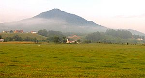
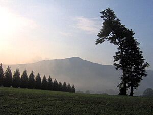
Roundtop Mountain overlooking Wears Valley
|
|
| Country | United States |
| State | Tennessee |
| County | Sevier |
| Population
(2010)
|
|
| • Total | 7,486 |
| Time zone | UTC-5 (Eastern (EST)) |
| • Summer (DST) | UTC-4 (EDT) |
| ZIP codes |
37862
|
| Area code(s) | 865 |
| GNIS feature ID | 1304427 |
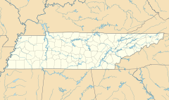
Wears Valley (sometimes called Wear Valley) is a small community in Sevier County, Tennessee. It's not an official city, but a place where people live and work together. In 2000, about 6,486 people lived here.
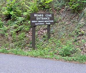
Wears Valley is located in a beautiful area called Wear Cove. This valley runs right next to the Great Smoky Mountains National Park. Because of this, the valley's history and economy are closely linked to the park.
Both the valley and the cove are named after Samuel Wear (1753–1817). He was a hero from the American Revolutionary War. He built a fort near the entrance to Wear Cove, in what is now Pigeon Forge.
Contents
Discovering Wears Valley's Population
As of the year 2000, Wears Valley was home to 6,486 people. These people lived in 2,585 households. About 1,955 of these households were families.
Most of the people living here, about 97.7%, were White. Other groups included Native American, Asian, and African American people. About 1.8% of the population were Hispanic or Latino.
Many households, 30%, had children under 18 living with them. Most households, 66.6%, were married couples living together. The average household had about 2.51 people.
The median age of people in Wears Valley was about 40.2 years old. This means half the people were younger and half were older.
Exploring Wears Valley's Geography
Wears Valley is located at 35°42′50″N 83°39′11″W / 35.71389°N 83.65306°W. The community covers most of Wear Cove. The southern border of the valley is the edge of the national park. The western border is the line between Blount and Sevier counties.
The main road through the community is U.S. Route 321 / Tennessee State Route 73. This road connects Townsend in the west to Pigeon Forge in the east. In Pigeon Forge, it joins with U.S. 441. This part of the road is known as "Wears Valley Road."
There's also Line Springs Road. It connects Wears Valley Road to Little River Road inside the national park. This road goes over Wear Cove Gap, between Cove Mountain and Roundtop. It comes out at the Metcalf Bottoms picnic area.
A new part of the Foothills Parkway opened in 2018. This section connects Wears Valley to the parkway at Walland. This makes it easier to travel to and from the valley.
Wears Valley's Past: A Look at History
Early Settlers and Their Stories
Wears Valley gets its name from Samuel Wear (1753–1817). He was a veteran of the American Revolutionary War. He built a fort near the valley's entrance, in what is now Pigeon Forge.
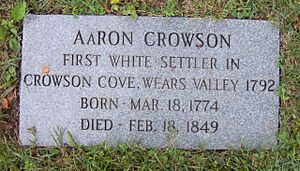
Aaron Crowson came to Wears Valley from North Carolina in 1792. This was a time when there was tension between the Cherokee people and the new settlers. In 1794, Crowson's friend, Peter Percefield, was killed in a Cherokee attack. Crowson got help from Wear's Fort. Percefield was buried on a hill in Wear Cove. This spot is now Crowson Cemetery.
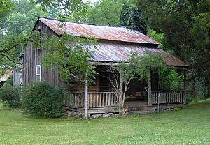
Other early settlers included William Headrick, who arrived in 1821. John Ogle, a veteran of the War of 1812, also settled here. Peter Brickey, another War of 1812 veteran, arrived in 1808. He had a large farm and made spirits in the valley. The log house he built around 1808 is still standing today. It is listed on the National Register of Historic Places.
The U.S. Civil War greatly affected farms in Wears Valley. In 1864, there was a report of a Cherokee raid in Wear Cove. Earlier in the war, a Union army marched through the valley. They were on their way to fight troops in Gatlinburg.
A local resident, William C. Pickens, was part of a group called the bridge-burners. These were people who supported the Union. They tried to destroy railroad bridges in November 1861. Pickens was hurt during an attack on the Strawberry Plains bridge.
After the war, Alfred Line (1831–1897) started a farm near Roundtop Mountain. A clear spring, Line Spring, flowed from the mountain. This spring gave its name to a small recreation area. In the late 1800s, people believed mineral springs were good for health. This brought early tourists to the area. In 1910, D.B. Lawson built the Line Spring Hotel. This hotel helped the valley's economy by buying food from local farmers.
Faith and Community: Religion in the Valley
Around 1800, settlers built a simple log church called Bethlehem Church. Both Methodists and Baptists used this church for many years. Sometimes, both groups would meet for a "union meeting," which was like a mini-revival. In 1886, the Baptists and Methodists built their own separate churches.
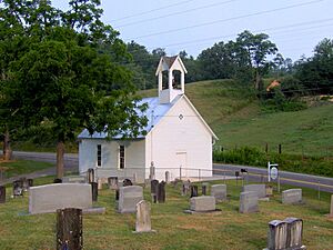
For most of the 1800s, funerals in Wears Valley were held at Headrick Cemetery. A large oak tree provided shelter during services. However, people needed a building for bad weather. In 1902, a lightning strike destroyed the oak tree. In response, residents built Headrick Chapel on the cemetery grounds.
The chapel was shared by four different church groups. Funeral services always had priority. The chapel's bell would ring once for each year of the person's life. This tradition is still followed today. In 2001, Headrick Chapel was added to the National Register of Historic Places.
The Great Smoky Mountains National Park's Influence
The Great Smoky Mountains National Park was created in 1934. The park's border runs along the southern edge of Wears Valley. After improvements to US-321 in the 1950s, more tourists started visiting Wears Valley. Today, you can find many cabin rentals and outdoor supply stores in the valley.
In 2005, some developers wanted to build 400 houses on Cove Mountain. Many Wears Valley residents were worried about how this would affect the beautiful mountain. A group called Friends of Wears Valley tried to stop the building plans. They put up "Save Our Mountains" signs. The developers said their plans would not harm the mountain's natural beauty.
Fires in Wears Valley
The 2016 Fire Event
In 2016, large fires affected the nearby towns of Pigeon Forge and Gatlinburg. Wears Valley also saw many cabins burn down. A fallen power line started a fire in Little Cove Gap. This fire quickly spread, destroying homes in the northern part of the valley. About 40 homes were destroyed, and another 40 were damaged.
The 2022 Fire Event
On March 30, 2022, a wildfire called the Hatcher Mountain Road/Indigo Lane Fire started in Wears Valley. The fire spread quickly across the Pigeon Forge area. Emergency services asked people in the area to leave their homes. A shelter was set up in Pigeon Forge. Schools were closed the next day.
Education in Wears Valley
Wears Valley is home to Wearwood Elementary School, providing education for local children.
 | Chris Smalls |
 | Fred Hampton |
 | Ralph Abernathy |


