
Old Black (Great Smoky Mountains) facts for kids
Quick facts for kids Old Black |
|
|---|---|

The summit of Old Black, looking southwest from the Appalachian Trail
|
|
| Highest point | |
| Elevation | 6,370 ft (1,940 m) |
| Prominence | 170 ft (52 m) |
| Geography | |
| Location | |
| Parent range | Great Smoky Mountains |
| Topo map | USGS Mount Guyot |
| Climbing | |
| Easiest route | Snake Den Ridge Trail + Appalachian Trail + bushwhack |
Old Black is a cool mountain located in the Great Smoky Mountains in the southeastern United States. Even though it's near Mount Guyot, which is taller, Old Black is still very important! It's the 5th highest mountain in Tennessee and the 7th highest in the Great Smoky Mountains National Park.
A famous hiking path called the Appalachian Trail goes along its western side. This trail connects different parts of the park, making it easier for hikers to explore. Old Black sits right on the border between Tennessee and North Carolina. On the Tennessee side, you'll find Cocke County and Sevier County. On the North Carolina side, it's Haywood County.
The mountain rises about 4,400 feet (1,341 meters) from its base on one side and 3,300 feet (1,006 meters) from another. Old Black is part of a larger group of mountains called the Guyot massif. It has a unique triangular shape, a bit like Tricorner Knob to the south.
Old Black got its name from the thick, dark green forest that covers its higher parts. This forest is made up of spruce and fir trees. From far away, especially in colder months, these trees look very dark compared to the brown trees lower down. This dense forest also makes Old Black look like a wide, low pyramid.
Contents
What is Old Black Mountain Made Of?
Old Black is made of a type of rock called Thunderhead sandstone. This rock is a Precambrian metamorphic rock, which means it's very old and has changed over time due to heat and pressure. It's part of something called the Ocoee Supergroup. These rocks were formed from ocean sediments almost a billion years ago!
The mountain itself was created over 200 million years ago. This happened during a huge event called the Appalachian orogeny. During this time, the North American and African land plates crashed into each other. This collision pushed the rocks upwards, forming the mountains we see today.
A Look Back: History of Old Black

The first person to measure Old Black's height was Arnold Henry Guyot. He did this in the late 1850s as part of his survey of the Smoky Mountains. Guyot measured the mountain at 6,373 feet (1,942 meters). This was very close to today's measurement, off by only three feet!
Guyot first wanted to name the mountain "Mount Henry" after the head of the Smithsonian Institution. But the name "Old Black" was the one that everyone started using, and it stuck.
A writer named Laura Thornborough visited the area in the 1930s. She wrote about how thick the spruce forest was in the eastern Smokies. She said that the Appalachian Trail goes through what might be the densest stand of spruce and balsam trees in the entire Great Smokies.
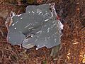
Plane Crash Near Old Black
In 1984, an F-4 Phantom fighter jet crashed into the ridge near Old Black. You can still find some parts of the plane scattered around the area. Many pieces are along the Appalachian Trail, about a quarter-mile west of where it meets the Snake Den Ridge Trail. There's even a short side trail that leads you through some of the wreckage.
In 1935, a group called the CCC helped build a part of the Appalachian Trail across the western side of Old Black. The CCC was a program that put young men to work on conservation projects during the Great Depression.
How to Visit Old Black Mountain

Reaching Old Black requires a long hike, like many of the main peaks in the eastern Smokies. The mountain is just over 6 miles (9.7 kilometers) from the closest parking lot at the Cosby Campground.
The fastest way to get there is to follow the Snake Den Ridge Trail from Cosby. The trailhead is behind Campsite B51. You'll hike about 5.3 miles (8.5 kilometers) until you reach the Appalachian Trail junction at Inadu Knob. From there, Old Black is almost a mile to the northwest.
The trail gets very close to the summit, less than a tenth of a mile away. However, the forest at the top is very thick. This makes it hard to walk off the trail and can make it difficult to find your way without a clear path.
As you hike along the Appalachian Trail on Old Black's western side, you'll find spots where the trees clear. These spots offer amazing views of Cocke County and Sevier County in Tennessee, looking north and northwest.
On the northeast side of the mountain, near a clearing used for helicopter landings, you can see much of the eastern Smokies and the Balsam Mountains. This includes peaks like Mount Sterling and Luftee Knob. It's also one of the best places to see Mount Guyot from a distance.
Images for kids
-
Wreckage from an F4 Phantom that crashed near Old Black in 1984
-
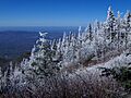
View from the western slope of Old Black, at just over 6,000 feet. Cocke County, Tennessee is below.
