Mount Cammerer facts for kids
Quick facts for kids Mount Cammerer |
|
|---|---|
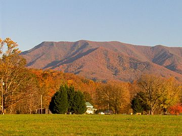
Mt. Cammerer, looking south from Cosby, Tennessee
|
|
| Highest point | |
| Elevation | 4,928 ft (1,502 m) |
| Prominence | 8 ft (2.4 m) |
| Geography | |
| Location | Cocke County, Tennessee / Haywood County, North Carolina, U.S. |
| Parent range | Great Smoky Mountains |
| Topo map | USGS Hartford |
| Climbing | |
| Easiest route | Low Gap Trail + Appalachian Trail + Mount Cammerer Trail |
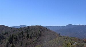
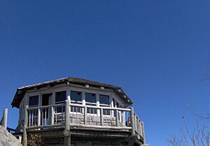
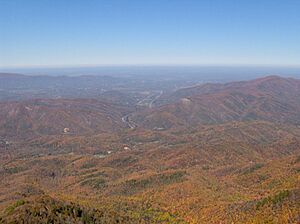
Mount Cammerer is a mountain located in the northeastern part of the Great Smoky Mountains. This mountain is special because it sits right on the state line. It divides Cocke County, Tennessee, and Haywood County, North Carolina. A famous hiking path, the Appalachian Trail, goes along its south side. At the very top, there's a restored fire lookout tower. From this tower, you can see amazing views of the eastern Smokies and the Blue Ridge Mountains.
Even though Mount Cammerer is connected to a taller hill nearby, it's easy to spot. You can see it from other mountains and from the town of Cosby. You can even see it from I-40 as you drive through Cocke County. Many people love to hike Mount Cammerer, especially in the fall. That's when the leaves on the trees turn bright red, orange, and yellow. It's a truly beautiful sight!
What is Mount Cammerer Made Of?
Mount Cammerer is mostly made of a type of rock called Thunderhead sandstone. This rock is very common throughout the Great Smoky Mountains.
How Old is the Rock?
Thunderhead sandstone is part of something called the Ocoee Supergroup. This rock formed about one billion years ago from sediments in an ancient ocean.
How Did the Mountain Form?
A long time ago, about 200 million years ago, two huge land plates collided. These were the North American and African plates. This collision, called the Appalachian orogeny, pushed the rock layers upwards. This is how the Appalachian Mountains, including Mount Cammerer, were formed. You can also see twisted, hard rock called quartzite at the very top of the mountain.
The Story of Mount Cammerer
Mount Cammerer got its name from Arno B. Cammerer. He was the Director of the National Park Service from 1933 to 1940. He played a big part in creating the Great Smoky Mountains National Park.
What Was its Old Name?
Before it was named Mount Cammerer, the mountain was known as "White Rock." This name came from the bright white rocks that stick out at the top. On some maps in North Carolina, you might still see it called "Sharptop." There's even a story that a lightning strike once made a hole at the summit. This hole filled with water and attracted ravens.
Who Lived Near the Mountain?
In the late 1800s and early 1900s, many law-abiding farmers lived around Mount Cammerer. A local writer, Mary Bell Smith, wrote about them in her book In the Shadow of the White Rock. Ella Costner, a famous poet from Tennessee, was born near the base of Mount Cammerer.
Building Trails and Lookouts
In 1934, a group called the Civilian Conservation Corps (CCC) built a camp at the mountain's base. They built most of the hiking trails and scenic overlooks in the area. The lookout tower at the summit was built by the CCC in 1937. They used rocks and timber found nearby. A fire ranger used to work in the tower until the 1960s. After that, it fell apart, but it was fixed up and restored in 1996.
How to Hike Mount Cammerer
There are a few ways to reach the top of Mount Cammerer.
The Quickest Path
The fastest way to the summit starts at the Cosby Campground.
- First, you hike up the Low Gap Trail.
- This trail connects to the Appalachian Trail at a spot called Low Gap.
- From Low Gap, it's about two miles (3 km) to the Mount Cammerer Trail.
- The Mount Cammerer Trail then goes about half a mile to the summit.
- The total hike from Cosby Campground to the top is just over five miles (8 km).
A Longer Loop Hike
Another popular way to explore is by doing a loop.
- Start at Cosby Campground and take the Lower Mount Cammerer Trail. This trail is about seven miles (11 km) long.
- It then meets the Appalachian Trail near Davenport Gap.
- Hikers often combine this with the Appalachian Trail and the Low Gap Trail to return to Cosby Campground.
- This longer loop, including the tower trail, is about 15 miles (24 km) in total.
Finding Your Way at Cosby Campground
The Cosby Campground has many trails. It can be a bit confusing!
- From the parking lot, a path goes east to the Lower Mount Cammerer Trail.
- To find the Low Gap Trail, follow the path next to Cosby Creek.
- Both trails are clearly marked.
Another Loop Option
You can also start from the Big Creek Campground (Exit 451 on I-40).
- This loop uses the Big Creek Trail, Low Gap Trail, Appalachian Trail, and Chestnut Branch Trail.
- This loop is also about 15 miles (24 km) long.
Stay Safe While Hiking
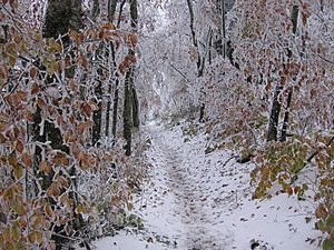
Hiking in the Great Smoky Mountains, especially Mount Cammerer, can be challenging. Sometimes, snow can fall early in the season. Always check the weather forecast before you plan any hiking trip.
- You can find more information about Tennessee fire towers.
 | Valerie Thomas |
 | Frederick McKinley Jones |
 | George Edward Alcorn Jr. |
 | Thomas Mensah |


