
Erwin, Tennessee facts for kids
Quick facts for kids
Erwin
|
|
|---|---|

View along Main Street in Erwin
|
|
| Motto(s):
"Where the Mountains and the People Welcome You."
|
|

Location of Erwin in Unicoi County, Tennessee.
|
|

Erwin
Location in Tennessee
|
|
| Country | United States |
| State | Tennessee |
| County | Unicoi |
| Settled | 1780s |
| Founded | 1876 |
| Incorporated | 1903 |
| Named for | David J.N. Ervin, early resident |
| Government | |
| • Type | Municipal Corporation |
| Area | |
| • Total | 4.13 sq mi (10.70 km2) |
| • Land | 4.13 sq mi (10.69 km2) |
| • Water | 0.01 sq mi (0.01 km2) |
| Elevation | 1,673 ft (510 m) |
| Population
(2020)
|
|
| • Total | 6,083 |
| • Density | 1,474.31/sq mi (569.20/km2) |
| Time zone | UTC-5 (Eastern (EST)) |
| • Summer (DST) | UTC-4 (EDT) |
| ZIP code |
37650
|
| Area code(s) | 423 |
| FIPS code | 47-24360 |
| GNIS feature ID | 1328148 |
| Website | erwintn.org |
Erwin is a town in Tennessee, USA. It is the main town, or county seat, of Unicoi County, Tennessee. In 2020, about 6,083 people lived there. Erwin is also part of a larger area called the "Tri-Cities" region.
Contents
History of Erwin
How Erwin Got Its Name
Erwin got its name because of a mistake! In 1879, the town was supposed to be called Ervin. This name honored D.J.N. Ervin, who gave land for the town. But postal workers made a typo, and it was written as Erwin. The name stuck!
Railroads and Erwin's Economy
From 1890 to 2015, railroad operations were very important to Erwin. They helped the town's economy and shaped its culture.
Several railroad companies tried to build lines through Erwin. The Charleston, Cincinnati and Chicago Railroad started in 1886. Trains ran through Erwin by 1890, but the company soon stopped.
Later, the Ohio River and Charleston Railway tried to finish the line. It also failed.
In 1909, the Carolina, Clinchfield and Ohio Railway (CCO) was completed. Its main office was in Erwin. This line connected Dante, Virginia to Spartanburg, South Carolina. In 1915, it was extended to Elkhorn City, Kentucky. This connected it to the Chesapeake and Ohio Railway (C&O). In 1924, the CCO officially became the Clinchfield Railroad (CRR).
In 1987, the C&O railroad joined with CSX Transportation. CSX kept the rail yard, diesel shop, and car repair facility in Erwin. This continued until 2015.
Southern Potteries Plant
Between 1916 and 1957, the Southern Potteries plant operated in Erwin. This factory made hand-painted dishes called Blue Ridge. These dishes became very popular across the country in the 1930s and 1940s. Today, Blue Ridge dishes are still popular with people who collect old dishware.
Rail Yard Closure
In October 2015, CSX closed all its operations in Erwin. More than 300 people in the town lost their jobs. Town leaders then started to focus on making Erwin a place for tourists. They hoped this would help the town's economy.
Hurricane Helene Flooding
In September 2024, Hurricane Helene caused major flooding in Erwin. Areas near the river were badly damaged. About 58 people had to be rescued by helicopters from the roof of Unicoi County Hospital. The hospital was almost completely covered by water. Police from Virginia helped with the rescues.
Part of the bridges on Interstate 26 over the Nolichucky River in Erwin were completely washed away by the floodwaters.
Geography of Erwin
Erwin is located at 36°8′42″N 82°24′39″W / 36.14500°N 82.41083°W. The town sits in a valley where North Indian Creek meets the Nolichucky River. The Nolichucky River flows through a narrow gorge before reaching Erwin. This gorge is a popular spot for whitewater rafting.

The town of Erwin is surrounded by the Cherokee National Forest. Mountains are visible in every direction. Buffalo Mountain is to the north, Rich Mountain to the west, and the Unaka Mountains to the south and east.
The Appalachian Trail passes east of Erwin. It crosses the Nolichucky River near a place called Unaka Springs. Close by is "Moaning Rock," a large boulder. Local stories say that if you touch this rock, it makes a moaning sound.
Interstate 26 goes through the western and southern parts of Erwin. Tennessee State Route 107 connects Erwin to Unicoi to the north. It also connects to the Embreeville area and Washington County to the west. Tennessee State Route 395 connects Erwin to rural areas in Mitchell and Yancey counties in North Carolina. This road crosses the Unaka Mountains at Indian Grave Gap.
The town covers about 4.13 square miles (10.70 km2) of land. Only a very small part is water.
Climate in Erwin
| Climate data for Erwin 1 W, Tennessee (1991–2020 normals, extremes 1979–present) | |||||||||||||
|---|---|---|---|---|---|---|---|---|---|---|---|---|---|
| Month | Jan | Feb | Mar | Apr | May | Jun | Jul | Aug | Sep | Oct | Nov | Dec | Year |
| Record high °F (°C) | 75 (24) |
82 (28) |
85 (29) |
90 (32) |
91 (33) |
101 (38) |
102 (39) |
101 (38) |
98 (37) |
92 (33) |
84 (29) |
78 (26) |
102 (39) |
| Mean daily maximum °F (°C) | 47.3 (8.5) |
50.8 (10.4) |
58.7 (14.8) |
68.4 (20.2) |
76.2 (24.6) |
82.8 (28.2) |
85.4 (29.7) |
84.9 (29.4) |
80.2 (26.8) |
69.9 (21.1) |
58.9 (14.9) |
50.3 (10.2) |
67.8 (19.9) |
| Daily mean °F (°C) | 35.9 (2.2) |
38.9 (3.8) |
45.8 (7.7) |
54.5 (12.5) |
63.0 (17.2) |
70.5 (21.4) |
73.8 (23.2) |
73.0 (22.8) |
67.6 (19.8) |
56.6 (13.7) |
45.7 (7.6) |
39.1 (3.9) |
55.4 (13.0) |
| Mean daily minimum °F (°C) | 24.5 (−4.2) |
26.9 (−2.8) |
33.0 (0.6) |
40.7 (4.8) |
49.8 (9.9) |
58.1 (14.5) |
62.2 (16.8) |
61.1 (16.2) |
55.0 (12.8) |
43.3 (6.3) |
32.5 (0.3) |
28.0 (−2.2) |
42.9 (6.1) |
| Record low °F (°C) | −20 (−29) |
−11 (−24) |
−5 (−21) |
19 (−7) |
24 (−4) |
37 (3) |
45 (7) |
45 (7) |
31 (−1) |
22 (−6) |
12 (−11) |
−5 (−21) |
−20 (−29) |
| Average precipitation inches (mm) | 3.46 (88) |
3.27 (83) |
3.82 (97) |
3.99 (101) |
4.83 (123) |
5.07 (129) |
5.51 (140) |
4.76 (121) |
3.28 (83) |
2.54 (65) |
2.83 (72) |
3.64 (92) |
47.00 (1,194) |
| Average snowfall inches (cm) | 3.4 (8.6) |
2.5 (6.4) |
0.9 (2.3) |
0.0 (0.0) |
0.0 (0.0) |
0.0 (0.0) |
0.0 (0.0) |
0.0 (0.0) |
0.0 (0.0) |
0.0 (0.0) |
0.1 (0.25) |
2.4 (6.1) |
9.3 (24) |
| Average precipitation days (≥ 0.01 in) | 12.0 | 11.0 | 11.9 | 10.9 | 13.4 | 13.3 | 13.8 | 12.3 | 9.6 | 8.4 | 9.3 | 11.6 | 137.5 |
| Average snowy days (≥ 0.1 in) | 2.3 | 1.4 | 0.9 | 0.1 | 0.0 | 0.0 | 0.0 | 0.0 | 0.0 | 0.0 | 0.1 | 1.2 | 6.0 |
| Source: NOAA | |||||||||||||
Population of Erwin
| Historical population | |||
|---|---|---|---|
| Census | Pop. | %± | |
| 1910 | 1,149 | — | |
| 1920 | 2,965 | 158.1% | |
| 1930 | 3,623 | 22.2% | |
| 1940 | 3,350 | −7.5% | |
| 1950 | 3,387 | 1.1% | |
| 1960 | 3,210 | −5.2% | |
| 1970 | 4,715 | 46.9% | |
| 1980 | 4,739 | 0.5% | |
| 1990 | 5,015 | 5.8% | |
| 2000 | 5,610 | 11.9% | |
| 2010 | 6,097 | 8.7% | |
| 2020 | 6,083 | −0.2% | |
| Sources: | |||
Erwin's Population in 2020
| Race | Number | Percentage |
|---|---|---|
| White (non-Hispanic) | 5,417 | 89.05% |
| Black or African American (non-Hispanic) | 19 | 0.31% |
| Native American | 10 | 0.16% |
| Asian | 11 | 0.18% |
| Other/Mixed | 185 | 3.04% |
| Hispanic or Latino | 441 | 7.25% |
In 2020, there were 6,083 people living in Erwin. There were 2,657 households and 1,632 families.
Economy and Culture
Nuclear Fuel Services has a large factory in Erwin. It started in 1957. This factory prepares enriched uranium to make fuel for nuclear reactors. It also changes other uranium compounds. They also make highly enriched uranium safer for use in power plants. In the past, the factory also worked with thorium compounds.
Education
All students in Unicoi County go to schools in the Unicoi County School District.
Sports
In 1940, Erwin had a Minor League Baseball team called the Erwin Mountaineers. They played in the Appalachian League. In 1943, the Erwin Aces played there. They were a team linked to the Chicago Cubs. The Aces won the 1943 Appalachian League championship. In 1944, the Erwin Cubs, another team linked to the Chicago Cubs, also played in Erwin.
Images for kids
-
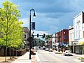
View along Main Street in Erwin
-
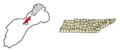
Location of Erwin in Unicoi County, Tennessee.
-
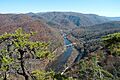
The Nolichucky River near Erwin, seen from the Appalachian Trail.
See also
 In Spanish: Erwin (Tennessee) para niños
