Unicoi, Tennessee facts for kids
Quick facts for kids
Unicoi
|
||
|---|---|---|

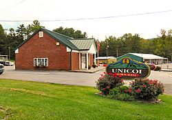
Unicoi Town Hall
|
||
|
||

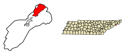
Location of Unicoi in Unicoi County, Tennessee.
|
||
| Country | United States | |
| State | Tennessee | |
| County | Unicoi | |
| Incorporated | 1994 | |
| Named for | Unaka, Cherokee for "white" | |
| Area | ||
| • Total | 16.19 sq mi (41.93 km2) | |
| • Land | 16.19 sq mi (41.93 km2) | |
| • Water | 0.00 sq mi (0.00 km2) | |
| Elevation | 1,923 ft (586 m) | |
| Population
(2020)
|
||
| • Total | 3,833 | |
| • Density | 236.75/sq mi (91.41/km2) | |
| Time zone | UTC-5 (Eastern (EST)) | |
| • Summer (DST) | UTC-4 (EDT) | |
| ZIP code |
37692
|
|
| Area code(s) | 423 | |
| FIPS code | 47-75820 | |
| GNIS feature ID | 1304219 | |
Unicoi is a small town in Unicoi County, Tennessee, United States. In 2020, about 3,833 people lived there. Unicoi is part of a larger area called the Johnson City Metropolitan Statistical Area. This area is also part of the "Tri-Cities" region, which includes Johnson City, Kingsport, and Bristol.
Contents
History of Unicoi
Unicoi was first known as "Greasy Cove." In 1851, two brothers named Swingle opened a post office there. They called the community "Swingleville." Later, in 1876, Dr. F.H. Hannum took over the post office. He changed the name to "Limonite."
When railroads came to the valley in the late 1880s, the town's name changed again. It became "Unicoi City," and then simply "Unicoi." In the early 1900s, Unicoi grew as a place to ship goods. These goods came from local mining and logging (cutting down trees) operations.
In 1994, the city government of Johnson City bought a golf course in Unicoi County. This made people in Unicoi worry that Johnson City might try to take over their land. To prevent this, a group of people worked together. They held a public vote the next year to make Unicoi an official town. This vote helped Unicoi stay independent.
Geography of Unicoi
Unicoi is located at coordinates 36.220028 degrees North and -82.338138 degrees West. The town sits in a beautiful valley called the North Indian Creek Valley. Here, North Indian Creek flows out of the mountains. It then turns southwest towards Erwin and eventually joins the Nolichucky River.
The northern parts of Unicoi are near the start of Buffalo Creek. This creek flows northeast, in the opposite direction from North Indian Creek. Buffalo Creek eventually flows into the Watauga River.
Unicoi is surrounded by the Cherokee National Forest. Buffalo Mountain stands tall to the west of Unicoi. To the east are rugged hills and ridges that are part of the Unaka Mountains. Erwin, which is the county seat, is southwest of Unicoi. Johnson City is north of Unicoi, across Buffalo Mountain.
Interstate 26 goes through the western part of Unicoi. Tennessee State Route 107 connects Unicoi to Erwin in the southwest. It also connects to the rural Limestone Cove area in the east. Tennessee State Route 173 links the town with U.S. Route 19E.
The United States Census Bureau says Unicoi covers about 16.3 square miles (41.93 square kilometers). All of this area is land.
Population and People
| Historical population | |||
|---|---|---|---|
| Census | Pop. | %± | |
| 2000 | 3,519 | — | |
| 2010 | 3,632 | 3.2% | |
| 2020 | 3,833 | 5.5% | |
| Sources: | |||
Unicoi's Population in 2020
In 2020, the 2020 United States census counted 3,833 people living in Unicoi. There were 1,421 households, which are groups of people living together. There were also 909 families in the town.
Most people in Unicoi are White (non-Hispanic), making up about 88.1% of the population. About 8.3% of the people are Hispanic or Latino. Other groups, like Black or African American, Native American, and Asian people, also live in Unicoi.
See also
 In Spanish: Unicoi (Tennessee) para niños
 | Jessica Watkins |
 | Robert Henry Lawrence Jr. |
 | Mae Jemison |
 | Sian Proctor |
 | Guion Bluford |


