Holston Mountain facts for kids
Quick facts for kids Holston Mountain |
|
|---|---|

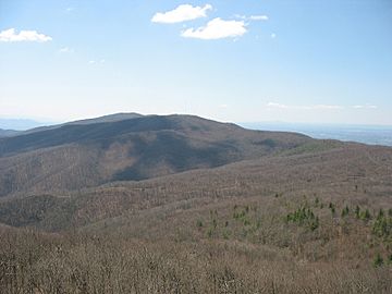
Holston High Point as seen from Holston High Knob.
|
|
| Highest point | |
| Elevation | 4,280+ feet (1,305+ m) ("Holston High Point" summit) |
| Prominence | 1,600 ft (490 m) |
| Geography | |
| Location | Tennessee and Virginia, U.S. |
| Parent range | Appalachian Mountains, Blue Ridge Mountains |
| Topo map | USGS Keenburg |
Holston Mountain is a long mountain ridge in Upper East Tennessee and southwest Virginia, in the United States. It is part of the Blue Ridge Mountains, which are a section of the larger Appalachian Mountains. Holston Mountain is a very noticeable ridge, stretching about 28 miles (45 km) long. It covers about 268 square miles (694 km²).
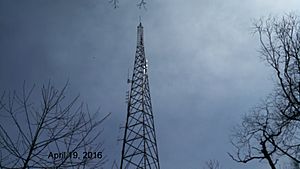
The highest point on Holston Mountain is called Holston High Point. It stands at 4,280 feet (1,304.5 m) above sea level. There's a special beacon for airplanes located there. The second highest spot is Rye Patch Knob, at 4,260 feet (1,298.5 m). The third highest is Holston High Knob, which has an old fire tower that is now used for communications. It is 4,136 feet (1,240.5 m) high.
Contents
Exploring Holston Mountain's Geography

Holston Mountain is mostly located within the Cherokee National Forest. It has natural borders all around it. To the northwest, you'll find South Holston Lake. To the southeast, there's Stoney Creek Valley, Shady Valley, and the Iron Mountains. The town of Damascus, Virginia, is to its northeast. To the southwest, you'll find the community of Keenburg, near Elizabethton, Tennessee.
The southern part of Holston Mountain forms a border between Sullivan County and Carter County. The northern part separates Sullivan and Johnson County. A small section at the very north even reaches into Washington County, Virginia.
Panhandle Road and Blue Hole Falls

Panhandle Road is a path that climbs Holston Mountain from the eastern side. It's about three miles (5 km) long. Sometimes, during heavy snow or ice, or during hunting and nesting seasons, this road is closed off.
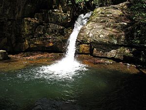
Near the start of Panhandle Road, there's a parking area. From there, a trail leads down to the beautiful Blue Hole Falls, which are about 45 feet (14 m) high. The last three miles of Panhandle Road along the top of the ridge can be rough with washouts. Driving there is at your own risk.
Another important road, U.S. Route 421, crosses Holston Mountain at a spot called Low Gap. This road connects the community of Shady Valley, Tennessee, with the city of Bristol, Tennessee.
Holston Mountain's History
Holston Mountain gets its name from the Holston River. The river itself was named after an early settler named Stephen Holston. In 1746, Stephen Holston built a cabin near the start of a small creek. The next year, surveyors named the creek "Holston's Creek" because he lived there. As pioneers followed the creek downstream, it grew into a large river, becoming known as the Holston River. This shows how a common settler's name became attached to a major natural feature.
Sadly, Holston Mountain has also been the site of plane crashes. On October 4, 1976, a U.S. Air Force plane crashed on the mountain. Years later, on September 1, 2007, a small plane carrying five people crashed on the southern side of the mountain, near the Holston High Point broadcasting antennas.
Trails for Hikers
The famous Appalachian Trail crosses over from Iron Mountain. It then runs along the upper northeast end of Holston Mountain. The trail eventually goes down the mountain into Virginia, passing through the town of Damascus. From there, it continues towards Mount Rogers, which is the highest point in Virginia.
Holston Mountain as a Communications Hub
Since the 1950s, people realized that Holston Mountain was a perfect spot for radio and television broadcasting. It's the highest visible point that faces many major cities in Upper East Tennessee and Southwest Virginia. These cities are located in the valley between Knoxville, Tennessee, and Roanoke, Virginia.
Because of its great location, Holston Mountain is home to the transmitting towers for five television stations in the Tri-Cities, Tennessee area. For example, the antenna for WCYB, digital Channel 5, is on Rye Patch Knob. The top of its antenna is 341 feet (104 m) above the ground. This makes it the highest broadcasting point in Tennessee, Virginia, and Kentucky.
The television towers for WJHL, digital Channel 11, and WKPT, digital Channel 19, stand side by side. They are located on the southwest slope of Holston High Point. The antenna for WJHL is 200 feet (61m) tall, and WKPT's antenna is 193 feet (58.8m) tall.
Holston Mountain also hosts the transmitters for several FM radio stations. These include WTFM-FM 98.5, WXBQ-FM 96.9, and WETS-FM 89.5. Many other government agencies and utility companies also use the mountain for their communication towers.
Holston Mountain is also a popular spot for amateur radio enthusiasts. For example, the kg4vbs repeater site is located on the highest peak. This site helps two-way radio communication cover seven different states! The tower for this site is 120 feet tall, with an additional 18 feet for the antenna.
Antenna Farms: Why Towers Group Together
The collection of broadcast towers on Holston Mountain is often called an "antenna farm." This is a common practice where radio and TV station owners place their towers close to each other. This idea became popular in the 1950s. Back then, most homes had outdoor antennas to get TV and radio signals. If you wanted a clear picture or sound, you would point your antenna towards the station's tower.
Other station owners soon realized it was smart to put their towers near existing ones. This way, viewers could easily get clear signals from many stations by pointing their antenna in one general direction. Even though TV and radio stations compete, they often share land or towers. This saves space, makes land available, and reduces the cost of building a transmission building on top of a mountain.
Other nearby "antenna farms" include Sharp's Ridge in Knoxville, Tennessee, and Poor Mountain in Central Virginia.
 | Madam C. J. Walker |
 | Janet Emerson Bashen |
 | Annie Turnbo Malone |
 | Maggie L. Walker |


