Poor Mountain facts for kids
Quick facts for kids Poor Mountain |
|
|---|---|

Poor Mountain from across Poages Valley in Roanoke, Virginia.
|
|
| Highest point | |
| Elevation | 3,928 ft (1,197 m) |
| Prominence | 1,448 ft (441 m) |
| Geography | |
| Location | Montgomery / Roanoke counties, Virginia, U.S. |
| Parent range | Appalachian Mountains, Blue Ridge Mountains |
| Topo map | USGS Elliston |
| Climbing | |
| Easiest route | Road |
Poor Mountain is a ridge with high peaks. It is located in Roanoke County and Montgomery County, Virginia. Standing at 3,928 feet tall, Poor Mountain is the highest point in its local area.
Poor Mountain is home to a special plant called piratebush. This plant gets its food from the roots of Eastern hemlock trees. Poor Mountain has the largest known group of piratebush plants by far. You can only find a few of these plants in other parts of Virginia, North Carolina, and Tennessee. To keep this important plant safe, the Poor Mountain Natural Area Preserve was created.
Twelve O'clock Knob is another mountain next to Poor Mountain. It is in Roanoke County, just south of Salem. The northern side of the ridge formed by Poor Mountain and Twelve O'clock Knob marks the edge of the Roanoke Valley. Fort Lewis Mountain is located right across the valley from Poor Mountain.
Communications Hub
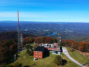
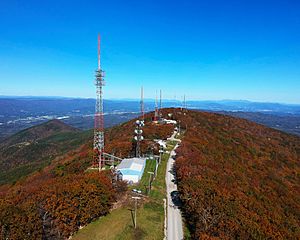
Poor Mountain is a very important spot for sending out radio and television signals. Many broadcasting antennas are located here. These antennas serve the Roanoke, Virginia and Lynchburg, Virginia area. This area is called a "Designated Market Area" (DMA).
At the very top of the mountain, there is a place called an "antenna farm." This is where many tall towers stand together. These towers hold antennas for various radio and television stations.
Radio and TV Stations
Some of the radio stations broadcasting from Poor Mountain include:
- WVTF (FM) 89.1
- WXL60 (VHF-FM) 162.475 MHz (NOAA Weather Radio)
- W220BD 91.9
- WXLK (FM) 92.3
- WSLC-FM 94.9
- WSLQ (FM) 99.1
Digital television stations located here are:
- WBRA-TV 3
- WDBJ 18
- WSLS-TV 30
- WFXR 17
- WPXR-TV 36
- WEDD-LD 26
All these stations are licensed to Roanoke. Other antennas on Poor Mountain are used for public services. These include local, county, state, and national communications. Their flashing lights can be seen from many miles away, especially at night. This is because the Federal Aviation Administration requires them for air safety.
It is common for radio and TV stations to put their broadcast towers close together. They usually choose the highest point near the city they serve. This helps their signals reach more people.
Wind Farm Plans
Poor Mountain has been considered as a possible location for a wind farm. A wind farm is a group of wind turbines that create electricity.
A company named Invenergy Wind LLC once thought about putting wind turbines on Poor Mountain. They also considered the nearby Bent Mountain. However, a study showed that the energy produced might be too much for the existing electricity transmission lines in the area. These lines carry electricity from power plants to homes and businesses.
Even with these concerns, the company is still trying to get approval for the project. They have already leased the land. They plan to install up to 54 wind turbines, each about 443 feet tall.
 | Toni Morrison |
 | Barack Obama |
 | Martin Luther King Jr. |
 | Ralph Bunche |


